Introduction
Mesozoic post-volcanic and Cenozoic sedimentary rocks record the degradation of the Jurassic and Early Cretaceous volcanic terrain and the onset of block-faulting which dominated Late Mesozoic tectonics. The distinctive red colour of the rocks indicates that a desert environment probably existed into the Late Cretaceous.
Classification
Post-volcanic Cretaceous and Tertiary sedimentary rocks are mainly classified lithostratigraphically on Hong Kong Geological Survey 1:20 000-scale maps. The formations are based on grain size, bedform and facies characteristics (see Chapter 3). Fossils are unknown from these Cretaceous rocks and their chronostratigraphy is based on correlation with sequences in Guangdong Province. Some fossils do, however, occur in the Tertiary strata.
Cretaceous
Regional Setting
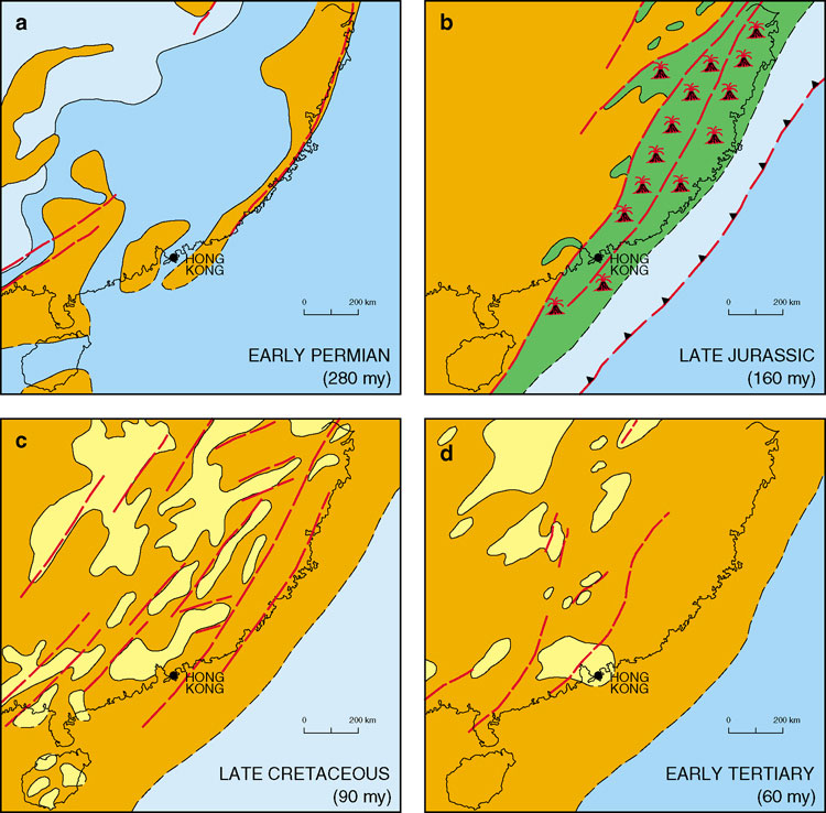
Magmatic activity in southeastern China waned in the Cretaceous as subduction, which had dominated the continental plate margin in the Middle Jurassic to Early Cretaceous period, ceased. The area remained largely emergent. Sedimentation was mainly confined to northeast-oriented, fault-controlled basins (Figure 2.6c). These were infilled with voluminous volcanic detritus from the degrading Middle Jurassic to Early Cretaceous magmatic province. Most of the preserved late Early Cretaceous and Late Cretaceous sequences in southeastern China consist of non-marine red bed successions indicating deposition under semi-arid conditions.
Distribution
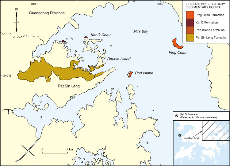
Cretaceous sedimentary rocks are largely confined to the northeast of Hong Kong. Their main outcrops (Figure 8.1) are along the Pat Sin Leng escarpment and on several islands in the west of Mirs Bay. A large area of subcrop lies beneath Mirs Bay and a small fault-bounded sliver is present along the Deep Bay Fault in northwest Hong Kong (Lai et al., 1996).
Stratigraphy
The Cretaceous sedimentary rocks of Hong Kong have long been recognized as comprising a continental red bed succession. They were first described by Heanley (1924) as "Red beds with basal conglomerate". Brock and Schofield (1926) renamed them the Pat Sin Conglomerates. Other workers variously described the rocks as Red Beds (Heim, 1929), the Mirs Bay Formation (Williams, 1943) and the Pat Sin Formation (Davis, 1952). Ruxton (1960) later proposed a two-fold subdivision: the lower Port Island Formation and the upper Kat O Formation. Subsequently, Lai et al. (1996) divided the Port Island Formation into two units: the Early Cretaceous Pat Sin Leng Formation and the Late Cretaceous Port Island Formation.
Pat Sin Leng Formation - Kp
Port Island Formation - Ki
Kat O Formation - Kk
Depositional environments
Jones (1995) has interpreted the conglomerates in the Pat Sin Leng Formation as fluvial channels within an alluvial plain/distal alluvial fan sequence. The sandstones and siltstones are considered to represent sheetflood events on the floodplain with much of the succession being reworked or redistributed by burrowing processes. Semi-arid conditions are indicated by the fact that periodic flooding alternated with sediment drying and dessication.
A distal alluvial fan or proximal braidplain was thought by Jones (1995) to be the most likely depositional environment for the Port Island Formation. The presence of cyclicity amongst the facies indicates periodic tectonic uplift in the hinterland that supplied the detritus to the basin. The major channels were filled by gravelly dunes that migrated downstream in an eastsoutheast direction. The thickness of the channel fills indicates water depths of up to 6 m. The minor channels were interpreted by Jones (op. cit.) as being the products of channel barforms within meandering channels. Based on the height of lateral accretion bedding, water depths of less than 4 m are envisaged. The sandy siltstone was deposited on the floodplain by a combination of suspension and tractional load. The massive nature of these deposits is probably due to the high degree of bioturbation, whereas dessication cracks indicate a subaerial floodplain. Siltstone with calcrete represents a palaeosol formed under semi-arid conditions. Although the silt was probably deposited from suspension, the calcrete nodules indicate subaerial emergence. The sheet sandstone formed from unconfined tractional flows on the floodplain (Jones, op. cit.).
The interbedded calcareous breccia and reddish brown sandstone suggest that the Kat O Formation is a talus, deposited, with some minor reworking, at the foot of a fault scarp under a semi-arid to arid palaeoclimate.
Palaeontology and correlation
No fossils have so far been recovered from the Cretaceous red bed successions of Hong Kong. However, in the Guangdong area immediately to the northeast of Hong Kong, red beds, known as the Baihedong Formation, have yielded a variety of Early Cretaceous fossils including ostracods, estherids, and plants. Similarly, the Sanshui Formation, which overlies the Baihedong Formation, has yielded Late Cretaceous fossil dinosaur eggs, ostracods and charophytes. The Early Cretaceous lithologies of the Baihedong Formation consist of red, coarse-grained clastic rocks with intercalations of greyish green mudstone and marls and are mostly likely to be correlatives of the Pat Sin Leng Formation. The Sanshui Formation consists of fluvio-lacustrine coarse clastic rocks, largely composed of detritus derived from a volcanic source, and is correlated with the Port Island Formation. Overlying the Sanshui Formation is the Dalangshan Formation, which is composed of purplish red sandstone, conglomeratic sandstone, and intercalations of dark grey mudstone and siltstone. These rocks are correlated with the Kat O Formation of Hong Kong.
Early Tertiary
Regional Setting
In southeastern China, terrestrial sedimentation in northeast-oriented fault-controlled basins continued into the Early Tertiary. In the Pearl River Delta area, there is no record of a break in sedimentation between the Late Cretaceous and Early Tertiary non-marine sequences. These rocks have yielded abundant fossil pollen and spore assemblages which have enabled a detailed biostratigraphy to be established ( Ping Chau Formation - Ep
Depositional environments
Jones (1995) has suggested that the well-laminated, thinly- bedded, and repeated nature of the siltstone and mudstone alternations in the Ping Chau Formation may represent seasonal fluctuations in sediment supply, water level and salinity. These, together with the interlaminated nature of the detrital and chemical deposits in general, indicate a semi-arid to arid palaeoclimate. Subaqueous deposition, possibly into a shallow lake via fluvial processes, is suggested by the cross lamination and wave ripples. The dark colour of the mudstones and the occurrence of pyrite nodules suggest reducing conditions, possibly caused by a high water table. The presence of carbonaceous matter suggests periodic humid conditions. Syneresis cracks formed by subaqueous dewatering and shrinking of the sediment beneath the lake (Jones, 1995). Periodic emergence of the lacustrine deposits is suggested by the presence of raindrop impressions and dessication cracks. Zeolite and aegirine are almost certainly secondary in origin and are likely to be related to low temperature (<200ºC) alteration by alkaline fluids (Kemp et al., 1997). This could also explain the Na-rich composition of the aegirine, and the presence of a Niobium-rich mineral.
Palaeontology and correlation
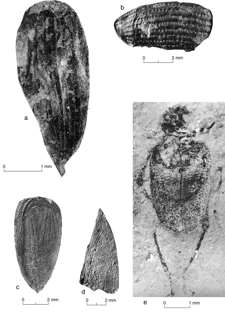
The Ping Chau Formation has yielded a diverse assemblage of fossil plants and insects (Plate 8.8). Of the thirty-five fossil plant genera that have been identified, angiosperms are the most abundant, followed by gymnosperms and pteridophytes (Lai et al., 1996). Angiosperm pollen and spores are the most abundant palynoflora and the fossil insect Coleoptera sp., first identified from Ping Chau by Williams (1943), has been confirmed.
According to Lai (1991) and Lai et al., (1996), the rocks of the Ping Chau Formation are most closely correlated with those of the Buxin Group of the nearby Dongguan and Sanshui basins which are thought to be Palaeocene to Eocene in age. Sedimentary rocks of the Buxin Group consist of interbedded reddish brown and dark grey mudstone, marl and siltstone containing gypsum.
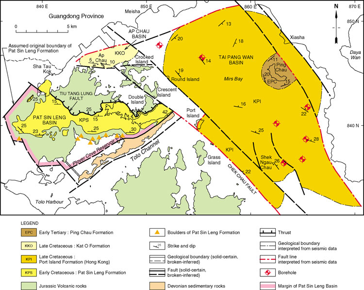
Basin development in the Hong Kong region
Three sedimentary basins are thought to have formed during the late Yanshanian and Himalayan orogenies. They are the Early Cretaceous Pat Sin Leng Basin, preserved mainly onshore in the northeastern New Territories, and the Late Cretaceous Tai Pang Wan and Ap Chau basins, both of which are preserved largely offshore in Mirs Bay (Figure 8.6). The Early Tertiary Ping Chau Formation overlies the Late Cretaceous sedimentary rocks of the Tai Pang Wan Basin without any marked stratigraphic break.
Pat Sin Leng Basin
The basin is bounded by faults. The southern boundary occurs along a fault stretching westerly from Bluff Head to Siu Kau, Wong Leng and beyond. The Sha Tau Kok Fault truncates the basin on its western side with some isolated outcrops of the Pat Sin Leng Formation occurring within the fault zone. On the north side of the basin, the Pat Sin Leng Formation is overlain along the Tiu Tang Lung Fault by the Late Jurassic Tai Mo Shan Formation (Figure 8.6). The orientation of the Pat Sin Leng Basin in relation to the thrust suggests that it may have been a foreland basin formed during north-south compression and sinistral strike-slip (transpression) on northeast-trending faults
Tai Pang Wan Basin
The Tai Pang Wan Basin is northwest-trending, approximately 10 km long, and is centred on Mirs Bay (Figure 8.6). The Chek Chau Fault, which strikes towards 130o and is downthrown on its northeast side, forms the western boundary of the basin. The eastern boundary is marked by a northwest-trending fault to the east of Ping Chau.
Sedimentary strata within the Tai Pang Wan Basin include the Late Cretaceous Port Island Formation, exposed on Round Island, Port Island and Shek Ngau Chau, and the Early Tertiary Ping Chau Formation, exposed on Ping Chau. The sedimentary rocks on both margins of the basin indicate deposition as piedmont alluvial fans onto an intermontane plain, while at the centre of the basin, deposition was within a brackish water lake. Early Tertiary strata form a very gentle syncline beneath Mirs Bay, with strata dipping at a low angle. The depositional centre of the Early Tertiary basin is approximately at Ping Chau, and the basin as a whole is interpreted as an asymmetric half graben, with downthrow to the east.
Ap Chau Basin
This basin is situated on the northern side of Crooked Harbour, and extends to Robinson Island and Crooked Island, a distance of 5 km. The basin contains reddish brown calcareous breccia of the Late Cretaceous Kat O Formation and is bounded to the north and south by easterly trending faults. The Ap Chau Fault forms the southern margin of the basin (Figure 8.6).