Introduction
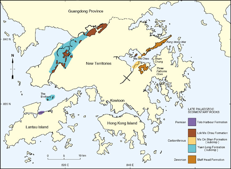
Late Palaeozoic rocks mainly occur as isolated outcrops in fault-bounded blocks in the northern and western parts of Hong Kong (Figure 3.1). They comprise approximately 10% of the onshore outcrop and are represented by Devonian, Carboniferous, and Permian sedimentary rocks, some of which have been thermally and dynamically metamorphosed. Collectively, these rocks record a period of approximately 150 million years. During this time, the Cathaysia Block (see Chapter 2) was gradually submerged by the sea following the Caledonian (Late Silurian) earth movements.
The stratigraphy of the Late Palaeozoic sedimentary rocks has only recently been finalized and detailed descriptions of the units are contained in several published memoirs and papers (e.g. Langford et al., 1989; Frost, 1992; Lai et al., 1996; Jones et al., 1997). The following account synthesizes this new information in the context of the regional geological history of southeastern China.
Classification
The Late Palaeozoic sedimentary rocks in Hong Kong have been classified both in terms of chronostratigraphy and lithostratigraphy. The chronostratigraphy (i.e. Early, Middle and Late Devonian, Carboniferous and Permian etc.) has been determined from the sparse macrofossil and microfossil content of the rocks. However, the rocks have been mapped and interpreted by the Hong Kong Geological Survey (at 1:20 000 and 1:5 000 scales) principally in terms of their lithostratigraphy (groups, formations and members). This has been largely based on grain size, bedform and facies characteristics.
Grain size
Grain and clast size estimations have been made semi-quantitatively using a x10 hand lens and comparative grain size charts, based on the scheme of Pettijohn et al.(1972). The term mudstone is used generally for fine-grained sedimentary rock between 0.0006 and 0.0625 mm. Mudstone is further subdivided, where possible, into claystone, silty claystone and fine- and coarse-grained siltstone. Sandstones are divided into very fine (0.0625 - 0.125 mm), fine (0.125 - 0.25 mm), medium (0.25 - 0.5 mm), coarse (0.5 - 1.00 mm), and very coarse (1.0 - 2.00 mm). The gravel-sized fraction that forms conglomeratic rocks comprises granules (2.0 - 4.0 mm), pebbles (4.0 - 64.0 mm), cobbles (64.0 - 256 mm), and boulders (>256 mm). Pebbles are further divisible into small (4.0 - 8.0 mm), medium (8.0 - 16.0 mm), large (16.0 - 32.0 mm), and very large (32.0 - 64.0 mm). Cobbles can be split into small (64.0 - 128.0 mm), and large (128.0 - 256.0 mm).
Bedforms
The bedform terminology used follows guidelines described in Ashley (1990). Bedforms are morphological elements produced by the friction between the top of a bed (e.g. the seabed or riverbed) and flow (e.g. of wind or water) above it. Bedform migration produces sedimentary structures. Small-scale bedforms, from 0.005 to 0.03 m in size (Leeder, 1982, p.86), are termed ripples. The sedimentary structure generated by ripple migration is termed cross lamination. Subaqueous ripples can form under the influence of either unidirectional flows (current ripples) or oscillatory flows (wave ripples). Where there is abundant fallout from suspension associated with current ripple migration, climbing ripple cross lamination is produced.
Facies
Modern approaches to sedimentological analysis generally concentrate on describing units in terms of facies and facies associations. The term facies has been defined as a body of rock with specific characteristics, distinguished on the basis of colour, bedding, composition, texture, fossils and sedimentary structures (Reading, 1986, p.4). Facies associations are groups of facies that occur together and are considered to be genetically or environmentally related (Reading, 1986). Such an approach enables depositional models to be proposed for each unit that can explain lateral and vertical changes in sedimentological style. This approach has been applied to all of the sedimentary rocks of Hong Kong.
Devonian
Regional setting
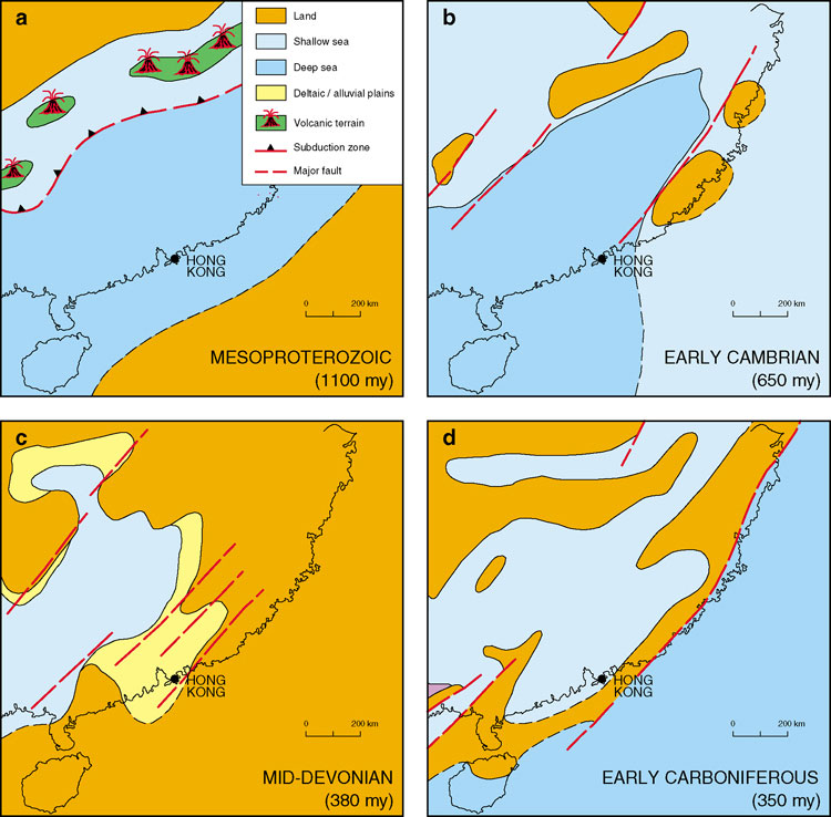
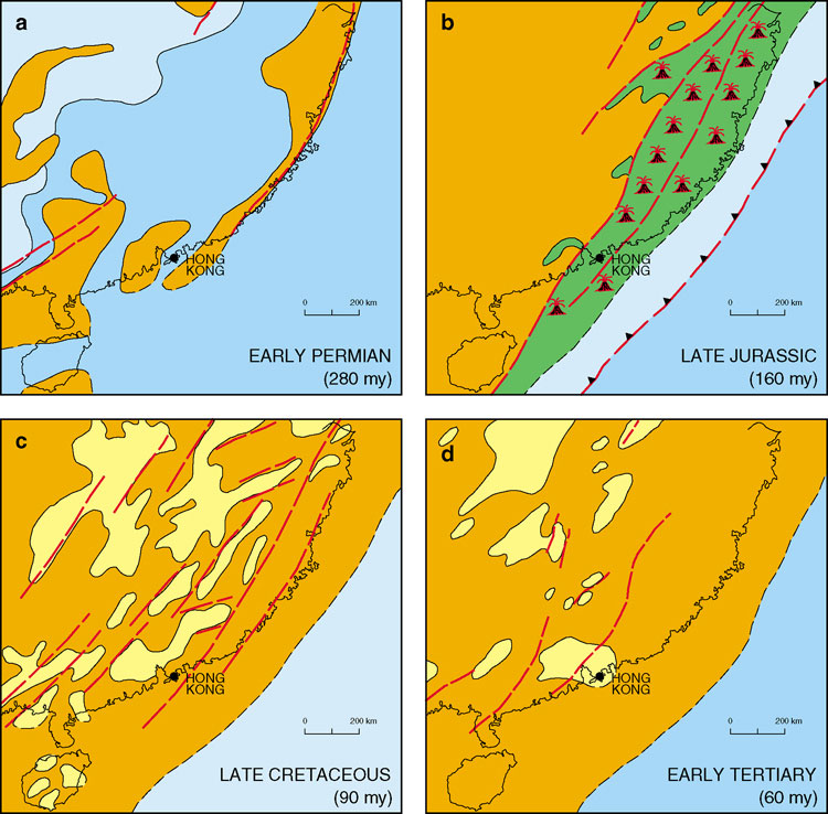
During the Devonian, marine sedimentation in southern China was restricted to the area from Yunnan to western Guangdong (Wang et al., 1985). It is thought that an alluvial plain occupied eastern Guangdong whereas a littoral environment existed in the west (Figure 2.5c). According to palaeogeographic reconstructions by Qiu (1992), Devonian terrestrial sediments were deposited in northeast-oriented basins with coarse-grained sediments derived locally from recently emergent massifs. Lacustrine environments were also present, marked by the presence of fresh-water fish fossils and land plants (Yang et al., 1986).
Distribution
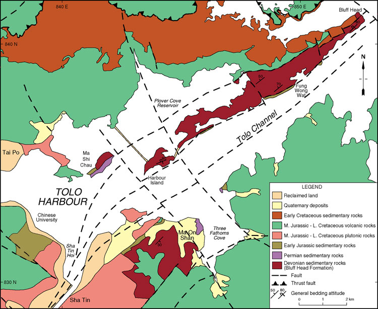
In Hong Kong, Devonian rocks crop out in two main areas: on the northern shore of Tolo Channel (Figure 3.2), and at Ma On Shan. North of Tolo Channel, they form a northeast-oriented ridge that is steep-sided in places. The ridge forms a distinct geomorphological feature extending from Harbour Island in the southwest to near Bluff Head in the northeast and is made up of a number of hills, some over 200 m in height. It has its widest development inWat, and narrows considerably to the northeast. On the western flanks of Ma On Shan, the Devonian rocks have been thermally metamoGranite and form a resistant ridge known as The Hunch Backs. In the north and east, the rocks are less metamorphosed and form a series of low hills.
Stratigraphy
Brock and Schofield (1926) proposed a threefold division of the sedimentary rocks of eastern Hong Kong and grouped the oldest of these as the Tolo Channel Formation. They proposed an Early Jurassic age for the formation and included within it successions on the northern and southern coasts of Tolo Channel, as well as Ping Chau. Ruxton (1960) and, later, Allen and Stephens (1971) assigned the outcrop of rocks between Tolo Channel and Plover Cove to the Bluff Head Formation, which they then considered as Permian. The area around Ma On Shan was assigned to the Repulse Bay Formation. During the mapping of the 1980s and 1990s (GCO, 1986a; GCO, 1989b; GEO, 1992; Addison, 1986; Strange et al., 1990; Lai et al., 1996), the stratigraphy was further refined (Table 3.1). Following the discovery of invertebrate fossils at Plover Cove (Lee et al., 1990a, b) and placoderm fish fossils at Harbour Island (Lee, 1982) the Bluff Head Formation has been shown to be Early to Middle Devonian in age to the north of Tolo Channel. Plant fossils from near Ma On Shan, on the southern side of Tolo Channel, have been identified as Late Devonian (Wong et al., 1997).
Bluff Head Formation - Db
Depositional environments
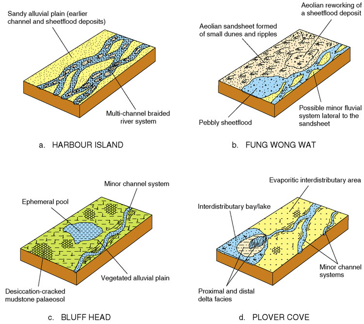
Jones et al. (1997) defined twenty-three sedimentary facies within the Bluff Head Formation and grouped them into five facies associations. These associations are described as channel, sheetflood, palaeosol, aeolian and deltaic. The lateral relationships of these facies are shown in Figure 3.4.
The majority of the Bluff Head Formation represents the deposits of fluvial channels, as is best shown at Harbour Island (Figure 3.4a). These are characterised by conglomerate filled channels with graded and cross bedding, and parallel laminated to massive sandstone. Minor channels (less than 4 m thick) are dominantly sandstone filled but are sometimes pebbly, especially in the basal part. The major channels are typically conglomerate filled, though they often grade upwards into sandstone. The channel facies are interpreted as migrating bars and dunes in fluvial channels on an alluvial plain.
The sheetflood facies association (Figure 3.4b) generally includes laterally persistent beds of conglomerate, pebbly sandstone and sandstone. The deposits typically have erosive bases, exhibit trough cross bedding and cross lamination, and are sometimes normally graded. These sediments are interpreted as deposits from pebble or sand laden unconfined sheet floods. Fining-upwards in the sandstones indicates a waning current.
The aeolian facies association, which is associated with the sheetflood facies, is seen only at Fung Wong Wat (Figure 3.4b). There, it comprises a sand body over 20 m thick, dominated by low angle trough cross bedded sandstone. The asymptotic foresets of alternating fine- and medium-grained laminae consistently dip south. Interbedded thinly and subhorizontally-laminated, fine- and medium-grained sandstone, is up to 50 mm thick. Conglomeratic lenses comprise thin, poorly-sorted pebble horizons. Jones (1995) interpreted the sandstones as aeolian on account of wind ripple lamination, and fine, evenly spaced laminae consistent with grainfall and grainflow. He interpreted the conglomerates as deflation lags.
The palaeosol facies association comprises mudstone with solution voids, ferruginous nodules and desiccation cracks, and sandstones with carbonate nodules (Figure 3.4c). These haematitic sediments are reddish brown to dark reddish brown, and occur at Fung Wong Wat, Bluff Head and Plover Cove (Figure 3.4b-d). They are commonly interbedded with minor channels and sheetflood sandstones and indicate long periods of drying-out, when dominantly fluvial conditions prevailed elsewhere on the flood plain.
The deltaic facies association, seen for example at Plover Cove (Figure 3.4d), is dominated by fine to medium grained sandstone and thin siltstone and mudstone beds. The sediments can usually be grouped into coarsening-upward cycles, from fossiliferous micaceous sandstone and mudstone through siltstone, sandy siltstone to sandstone, sometimes with a capping of erosively-based sandstone. A wide range of sedimentary structures are seen, including cross bedding, sometimes grading upwards into ripple lamination, and graded bedding. The presence of both plant and marine fossils, indicate a deltaic to littoral plain environment of deposition (Lee et al., 1990a; Jones, 1995).
Periods of coarse sediment supply led to the formation of multi storey channel complexes which alternated with relatively quiescent periods, marked by aeolian sandsheet and palaeosol development. The upper part of the formation, while still dominated by fluvial deposition, saw the increasing influence of deltaic processes as a result of periodic drowning of the alluvial plain.
Palaeontology and correlation
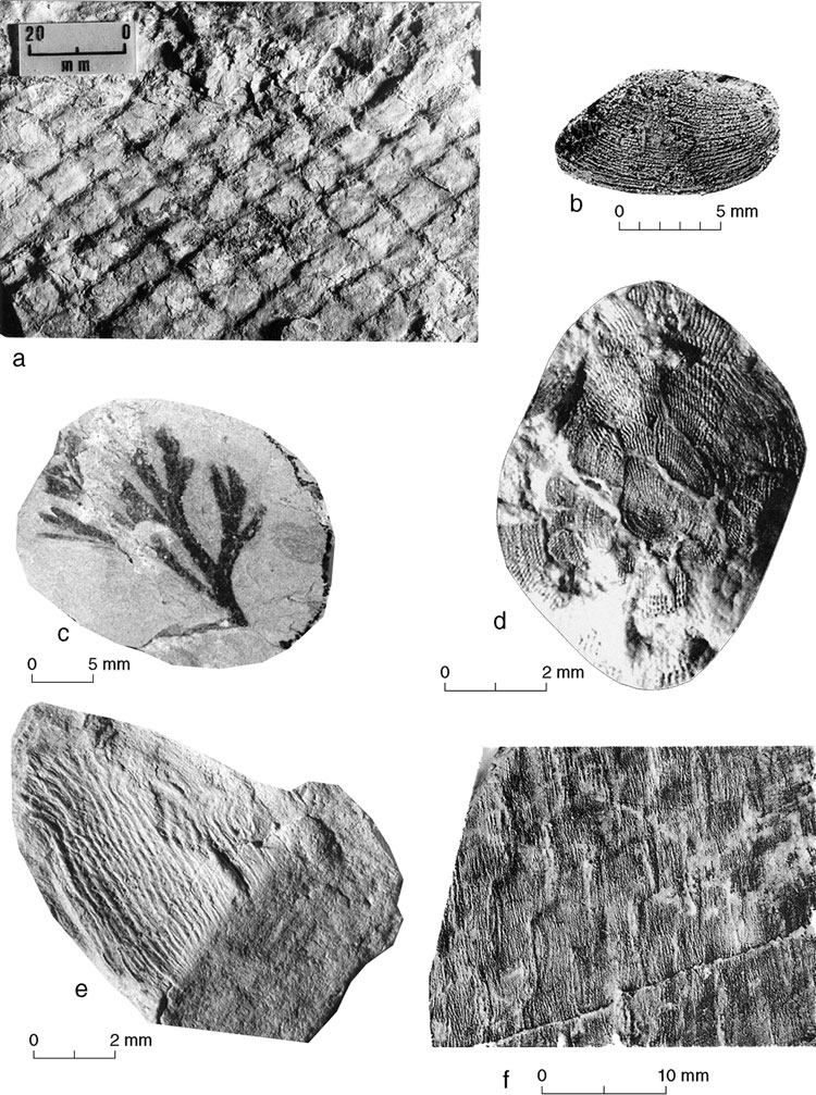
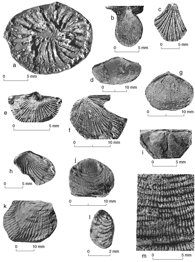
Fish fossils recovered from the Bluff Head Formation at Harbour Island (Lee, 1982) include ten fragments of placoderm plates indicating a Middle Devonian age. In addition to these fossils, nearly 300 other fossil specimens have been collected from the Plover Cove area, including bivalves, ostracods, conchostracans, gastropods, crinoids, and plants (Lee et al., 1990a, b) (Plate 3.4). Collectively, these fossils range in age from Early to Middle Devonian and on this basis the Bluff Head Formation is correlated with the Early to Middle Devonian Laohutou and Chunwan formations of Guangdong Province.
More recently, Hu et al. (1997) have discovered plant fossils in the Bluff Head Formation on the southern side of Tolo Channel, near to Ma On Shan. These include Leptophloeum rhombicum, which is diagnostic of the Late Devonian.
Carboniferous
Regional setting
During the Carboniferous, southern China was covered by an extensive epicontinental sea with shallow water and a gentle seabed(Li & Li, 1988). The surrounding area to the north, east and west was a low-lying landmass with a broad coastal area and widely-distributed tidal flat sediments (Figure 2.5d). Luxuriant vegetation fringing the landmass was responsible for the development of coal measures over much of China (Yan et al., 1986). A number of low-lying islands dotted this sea in the early Carboniferous but with general submergence, the late Carboniferous led to a more open sea area. The sea supported a shallow marine fauna, and planktonic and oceanic organisms were rare.
During the Carboniferous, Guangdong Province developed from a dominantly shoreside tidal-flat facies to a platform - flat facies. Li and Li (1988) characterised the shoreside tidal flat facies as thin- to medium-bedded, cross-laminated bioclastic micrite, dolomite, dolomitic limestone, and argillaceous bioclastic limestone. In contrast, they described the platform - flat facies as medium- to thick-bedded, lenticular cross-bedded, bioclastic micro-fine crystalline limestone, argillaceous limestone, carbonaceous and calcareous shale, and dolomitic limestone sequences. In addition, Li and Li (1988) identified a platform - swamp basin facies comprising microcrystalline bioclastic micrite, cherty micrite, argillaceous limestone, and mudstone with coal beds.
Distribution
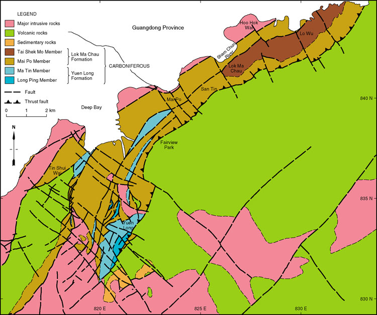
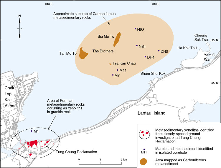
Carboniferous rocks are present throughout the north-western parts of Hong Kong (Figure 3.5). The oldest rocks (limestone and marble) do not occur at outcrop, but have been penetrated in boreholes, principally in the Yuen Long and Ma On Shan areas. Marble subcrop, also considered to be of Carboniferous age, occurs beneath the seabed to the east of The Brothers islands (Figure 3.12). However, subcrops of limestone and marble, proven in boreholes at Tung Chung, were recently shown to be Permian in age (Lee et al., 1998). Sizeable blocks of marble, assumed to be Carboniferous in age, have been found west of Shing Mun Reservoir in coarse volcanic deposits (Shing Mun Formation) of Jurassic age. Similarly, at Tai Po, small clasts of marble occur widely throughout Jurassic volcanic rocks, indicating the likely presence of Carboniferous limestone beneath much of the northern area of Hong Kong.
Younger Carboniferous rocks are present in the northwestern New Territories in a northeast-trending outcrop stretching from Tuen Mun to Lo Wu, and also between the three islands of West Brother, East Brother and Reef Island.
Stratigraphy
The basal relationships of the Carboniferous succession are not known. In the eastern New Territories, the strata that occur in subcrop are present in small fault wedges (Frost, 1990), where they are thrust over Jurassic volcanic rocks to the south. To the north, granitic rocks are intruded into the sequence. In the Tolo Harbour area, marble occurs in a small fault wedge between granite blocks.
The Carboniferous rocks of Hong Kong all belong to the San Tin Group (Langford et al., 1989). This is divided into three formations: the oldest being the Yuen Long Formation and the Ma On Shan Formation, and the youngest being the Lok Ma Chau Formation (Table 3.1). As there are no discernible differences between the marbles from the Yuen Long and the Ma On Shan formations, description of the Ma On Shan Formation is given under the Yuen Long Formation below.
Yuen Long Formation (Ma On Shan Formation) - Csy
Lok Ma Chau Formation - Csl
Depositional environments
The Yuen Long Formation is interpreted as having been originally deposited as a pure to slightly impure limestone in a platform setting. The Ma On Shan Formation is likely to represent a similar depositional environment. Fluctuating supply of terrigenous sediment to the basin is thought to have been responsible for the differences in clastic content between the Long Ping and Ma Tin members of the Yuen Long Formation. The presence of silt and mica in the lower part of the sequence possibly indicates the proximity of swamps or tidal flats, or a river draining the low-lying hinterland. Peritidal areas often exhibit cyclic sedimentation, typified by shallowing-upward successions. Such cycles may be reflected in vertical variations in colour within the marble from dark to pale grey, as have been recorded (Frost, 1992), though metamorphism has mostly destroyed the evidence of cyclicity.
The Lok Ma Chau Formation has been interpreted in terms of deposition in neritic swamps within a prograding deltaic environment (Lai et al., 1996). The lithologies are characteristic of the platform - swamp basin and shore - plain facies associations of Li and Li (1988). The siltstones, fine-grained sandstones and carbonaceous horizons of the Mai Po Member are interpreted as having been deposited on a deltaic floodplain, the finer lithologies representing more distal environments. The wavy and lenticular bedding in the fine-grained sedimentary rocks suggests a tidal flat, or delta front environment of deposition. This type of bedding commonly forms where there are fluctuations in sediment supply, or current (or wave) activity. Other sedimentary structures, such as small scale cross bedding and grading in the fine grained sandstones, together with rapidly alternating beds of siltstone and fine grained sandstone, indicate a shallow water environment with varying tidal or fluvial influences. Some lithologies recur throughout the succession but no cyclicity has been established. The carbonaceous material indicates a neritic environment, probably in a fan delta. Overall, the facies association is typical of a neritic tidal swamp or deltaic alluvial fan.
In the northwest New Territories, where the overlying Tai Shek Mo Member is best developed, the general coarsening of sediment from siltstone and sandstone to conglomerate is interpreted as being part of a prograding fluvial floodplain sequence. As the delta advanced, the average grain size of the sediments increased gradually, culminating in the deposition of coarse sand and pebbles within proximal alluvial environments.
Palaeontology and correlation
No Carboniferous fossils have been found in the marble. Therefore, the age of both the Yuen Long and Ma On Shan Formations remains in some doubt. Comparison with strata exposed in Shenzhen (Lai & Mui, 1984) suggests an Early Carboniferous age for the Yuen Long Formation and it may be the lithological equivalent of the Shidengzi Formation in Guangdong. However, limestone of Permian age has been proved at Tung Chung (see below) and it is possible that the Ma On Shan Formation and other marble occurrences, which lie along the same northeasterly trend as the marble at and near Tung Chung (Kirk, 2000), could be Permian in age.
Despite the thermal metamorphism of the Lok Ma Chau Formation, a microfaunal assemblage has been recovered from the graphitic schist in the Yuen Long area. Several fossils, including Densosporites anulatus, Lycospora pusilla, Savitrisporites nux and Punctatisporites sp., confirm a Carboniferous age (Langford et al., 1989). Graphite from West Brother island has yielded a sparse microflora containing Calamospora breviradiata and Densosporites annulatus (Langford et al., 1995), which also indicate an Early Carboniferous age. On Kat O Chau, dark grey siltstone and thinly bedded limestones, believed to belong to the lowermost part of the Mai Po Member of the Yuen Long Formation (Plate 3.7), have yielded the foraminiferan Archaesphaera magna.
Based on both microfloral and lithological similarities, the Lok Ma Chau Formation is best correlated with the Early Carboniferous Ceshui Formation which outcrops in Shenzhen.
Permian
Regional setting
The Yangtze Block became submerged during the Permian as Hercynian earth movements ceased and southeastern China developed into an area of stable platform sedimentation (Yang et al., 1986). Marginal marine conditions, which had persisted during the Carboniferous, continued into the Early Permian. By the Late Permian, the shallow sea to the southeast was slowly deepening and a peritidal environment developed, fed by clastic sediments derived from a low-lying land area in the southeast (Figure 2.6).
Distribution
Rocks of Permian age are mainly exposed in the vicinity of Tolo Harbour in the central New Territories. The outcrops are on Ma Shi Chau and Centre Island (Figure 3.2). Limestone and marble also occur in boreholes near Tung Chung on Lantau Island (Figure 3.12). These rocks contain Permian fossils (Lee et al., 1998). However, limestone and marble, proven in nearby subcrop east of The Brothers islands, is considered to be Carboniferous, although this has yet to be confirmed palaeontologically, and these strata could alternatively be Permian in age. Other more localized occurrences of marble along the coast of north Lantau Island (Figure 3.12) are similarly of unknown age, but could be Permian, as might the marble at Ma On Shan, yet further to the northeast.
Stratigraphy
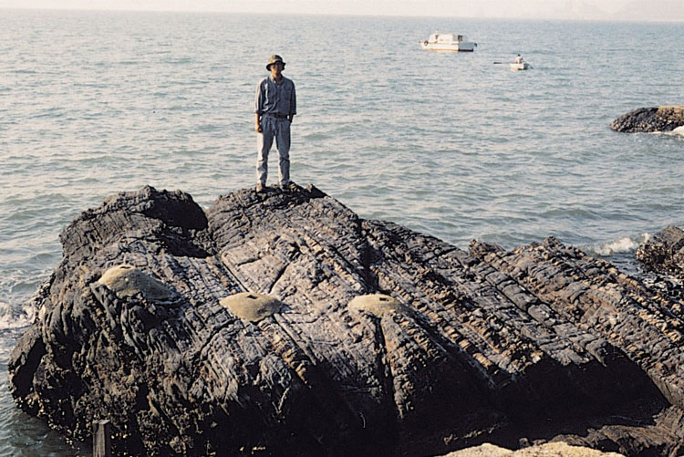
In the Tolo Harbour area, Permian fossils were first identified on Ma Shi Chau by Ruxton (1960) who assigned the rocks to the Tolo Harbour Formation. The Tolo Harbour Formation mainly occurs in fault wedges and is intruded by Jurassic and Cretaceous granitoids. The base of the formation is not exposed and the succession is tightly folded. The type section is at Ma Shi Chau (Figure 3.13) where the formation has an estimated thickness of 500 m (Addison, 1986).
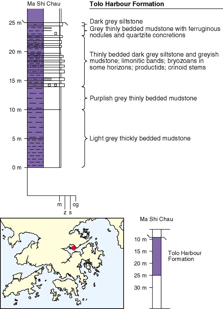
The limestone and marble that occur in boreholes near Tung Chung on Lantau Island (Figure 3.14) were assigned to a new formation, the Tung Chang [sic.] Formation, by Lee et al. (1998). However, following extensive borehole sinking in the Tung Chung area, the limestone and marble subcrops, of which there are several, have been shown to be xenoliths within a granite host (Kirk, 2000). In the absence of stratigraphic contacts, these occurrences are not regarded as sufficient basis for the new formation proposed by Lee et al. (1998). Instead, they are described here in terms of their lithology and palaeontology, and are related, only in broad stratigraphical terms, to the Tolo Harbour Formation.
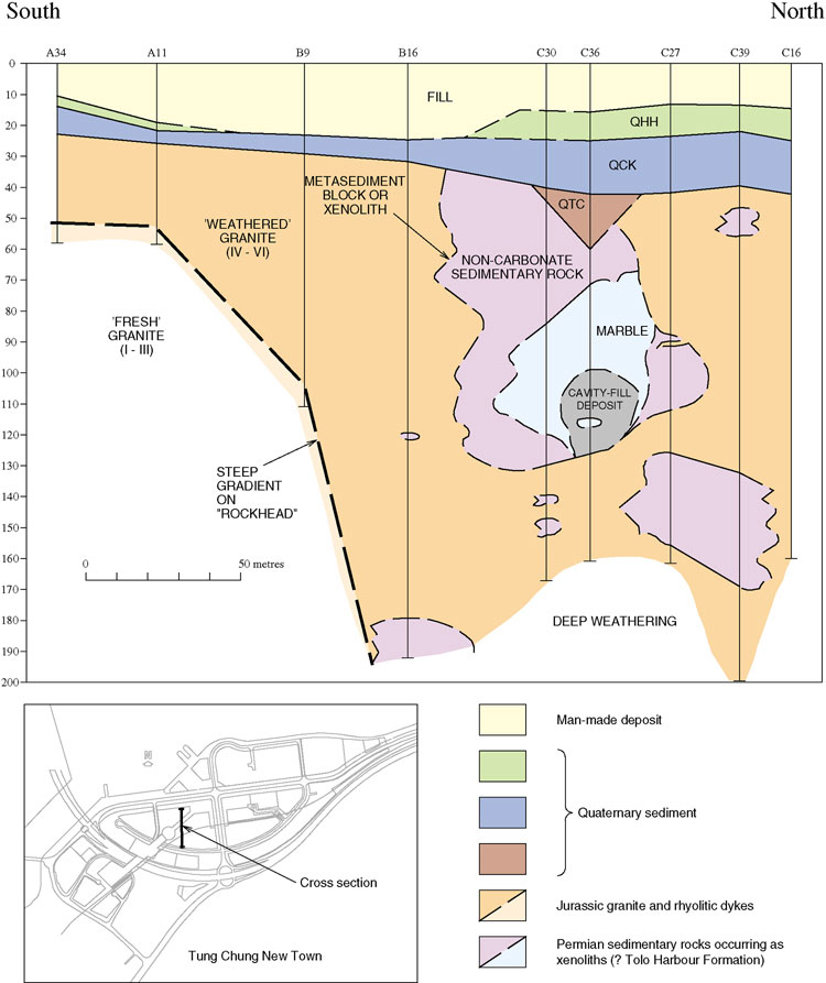
Tolo Harbour Formation - Pt
Depositional environments
The sedimentary rocks of the lower unit of the Ma Shi Chau Formation display features that are characteristic of the shore-plain to shoreside tidal-flat facies. These include thin to medium-bedded horizontal and cross-bedded sandstones and the presence of both corals and plant fossils.
The sediments of the upper unit are of the shore-plain to fluvial-plain facies, including similar features to those of the unit below, but with an absence of marine fossils. The general coarsening upwards of sediment and the presence of conglomerate suggest the fluvial-plain facies.
Although tidal flat, shore-plain deposition dominated the lower part of the Permian succession, the environment of deposition of the upper part was probably alluvial plain, with occasional river channels cutting through the area. Whether the increase in clastic sedimentation and the channel deposits were a function of renewed tectonic activity or of channel switching is unclear.
Palaeontology and correlation
A number of fossils have been collected from the Tolo Harbour Formation, principally from Ma Shi Chau. Plant fragments are also present on Centre Island (Lee et al. 1997).
An Early Permian fusilinid-bearing limestone has been identified at Tung Chung (Lee et al. 1998). Fossils recovered include Schwagerina callosa, Schwagerina spp. and Rugosochusenella hutiensis.
Marine fauna include the brachiopods and Buxtonia (Ruxton 1960 ; Lam, 1973), bivalves including Aviculopecten, bryozoa, crinoid ossicles (Ruxton 1960 ) and the coral Duplophyllum mikron (Yim et al. 1981) (Plate 3.9).
Plant fragments recovered from the formation include Cladophelbis sp. (Nau, 1980) and Pecopteris norinii (Addison 1986), indicating a marginal marine environment.