Introduction
As a prelude to the detailed description of the geology of Hong Kong, it is useful to examine its wider geological context. This is particularly important in regard to interpreting Hong Kong's concealed basement rocks, its deep structure, and its older sedimentary rocks which have very limited areas of outcrop. The following account is based largely on a review of published literature.
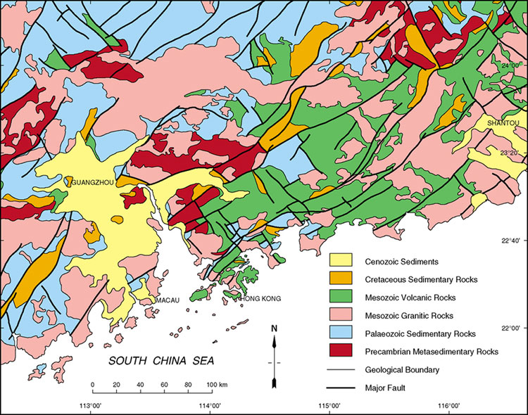
Hong Kong is situated on the southeastern margin of the Asian landmass which, in China, consists predominantly of Precambrian gneisses (4000 - 2500 Ma), Neoproterozoic (1000 - 550 Ma) and Phanerozoic (<550 Ma) sedimentary rocks, and Mesozoic volcanic rocks and granites (Figure 2.1). This continental crust is an amalgamation of several tectonic blocks, whose boundaries are defined by structurally complex zones. These contain an assemblage of ophiolites, melanges and high pressure metamorphic rocks. The ophiolites are considered to represent the remnants of ocean floor volcanic rocks, whereas the melange and high pressure rocks are indicative of subduction-related processes. Commonly, the boundaries between the blocks are also associated with arc volcanism and granite plutonism.
The continental crust of China extends for over 200 km offshore (Figure 2.2). Further to the east, the Philippines and Taiwan form part of a series of volcanic island arcs that are related to the northeastward spreading and subduction of the Philippines Oceanic Plate. To the southeast, the South China Sea is floored by oceanic crust which formed by sea floor spreading between 30 and 8 million years ago (Taylor & Hayes, 1980, 1983). In response to this period of spreading, a series of extensional, fault-bounded sedimentary basins developed along the continental margin (Feng & Fan, 1988).
Tectonic setting of southeastern China
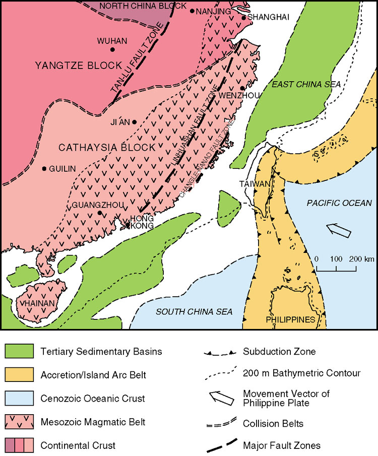
Southeastern China is composed of two major crustal blocks: the Yangtze Block, bounded to the north by the North China Block; and the Cathaysia Block in the south (Figure 2.2). Together, these comprise the South China Block. The basement of the Yangtze Block consists of late Archaean rocks in the east and younger Palaeoproterozoic (2500 - 1600 Ma) to Mesoproterozoic (1600 - 900 Ma) rocks in the west (Wang & Mo, 1995). The age of the basement to the Cathaysia Block is not so well constrained, due to the strong tectonic overprinting during the Phanerozoic. It has commonly been assumed that the Cathaysia Block is underlain by Palaeo- to Mesoproterozoic continental crust (Jahn et al., 1990; Li et al., 1992; Li, 1994; Li & McCulloch, 1996). However, recent isotope evidence from Hong Kong suggests that Archaean rocks may also be present at depth (Davis et al., 1997; Darbyshire & Sewell, 1997; Fletcher et al., 1997).
The timing of collision between these blocks has been the focus of considerable debate over the last two decades. The collision of the North China and Yangtze blocks has been assigned to both the Palaeozoic (Zhang et al., 1984; Mattauer et al., 1985) and the Mesozoic (Klimetz, 1983; Sengor, 1984; Lin et al., 1985). Similarly, there is no complete agreement as to the timing of collision between the Yangtze and Cathaysia blocks. Hsu et al., (1988, 1990) proposed that collision occurred in the Mesozoic, but there is strong evidence that the suturing occurred in the late Mesoproterozoic or early Neoproterozoic. For example, ophiolite assemblages within the collision zone have yielded ages between 930 + 34 and 1034 + 24 Ma (Chen et al., 1991; Xing et al., 1992), and the ages of granite intrusions along the suture range between 950 - 900 Ma. In addition, the variation in isotope composition of mid- to late-Neoproterozoic sediments derived from the southern margin of the Yangtze Block has been attributed to a continent - island arc - continent collision during the Neoproterozoic (Li & McCulloch, 1996).
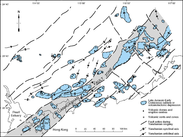
It has been postulated that the eastern part of the Cathaysia Block is, in turn, composed of an amalgamation of at least three microcontinental fragments (Zhang et al., 1984; Guo et al., 1989; Chen et al., 1993; Gilder et al., 1995, 1996; Sewell et al., 2000), although few rock assemblages that could be related to such suturing events remain. Two major northeast-trending fault zones have been considered as surface expressions of deep-seated sutures. One, the Changle - Nanao Fault Zone, runs along the eastern coastal tract and separates metamorphosed, early Palaeozoic, volcanic arc assemblages from the Mesozoic igneous province to the west (Guo et al., 1989; Gao & Huang, 1991). The other, the Lianhuashan Fault Zone (Chen, 1987), runs parallel to the continental margin from just south of Shanghai to Hong Kong (Figure 2.3).
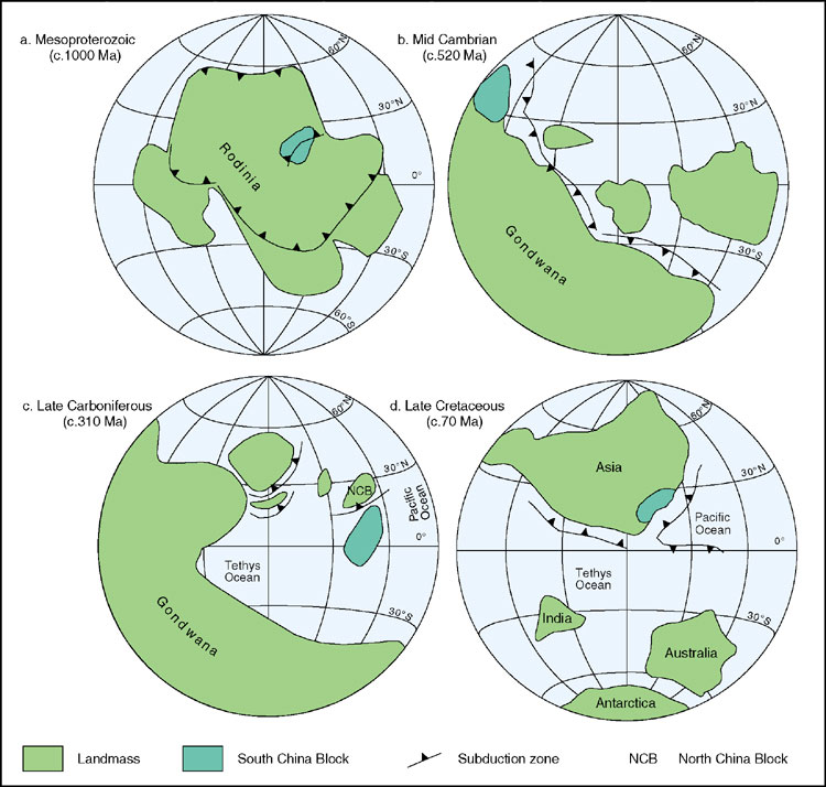
The South China Block, together with other continental blocks including Australia, North China, India, South America and Africa, was part of the supercontinent Rodinia during the early Neoproterozoic (Figure 2.4a). At the beginning of the Palaeozoic era, the supercontinent of Gondwana had been established in the southern hemisphere, and the South China Block lay along its eastern margin (Figure 2.4b). Both the North and South China blocks detached from Gondwana during the early Palaeozoic (Figure 2.4c), and amalgamated with other Asian and European blocks during Permian to Jurassic times to form the Eurasian continent. India drifted northwards, away from Gondwana, during the Cretaceous and collided with Eurasia during the Cenozoic (Figure 2.4d).
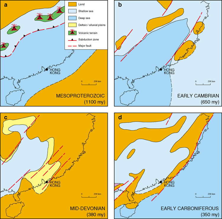
Palaeogeography of southeastern China
Precambrian rocks of Neoproterozoic age (Figure 2.1) are widely exposed over southern China within a series of northeast-trending depositional basins and troughs (Figure 2.5a). In the early Sinian, the basement gneisses of the Yangtze Block formed a large landmass to the northwest. Basement was also possibly exposed along the present southeastern coastline. In the northwest, volcaniclastic sediments, with some intercalations of intermediate and acid volcanic material, were deposited within the littoral and shelf environments. To the southeast, thick sequences of mud- and sand-dominated turbidites were deposited within a basinal environment. By late Sinian times, although the sea had transgressed over most the Yangtze Block, the marine sedimentary environments to the southeast remained fairly constant. Volcanic activity diminished markedly, except for some minor andesitic volcanism in the northeast. Sedimentation continued into the early Palaeozoic without a break in Guangdong.
In the early Palaeozoic (Figure 2.5b), the northeast-trending basin had been firmly established in southeastern China, with a chain of islands lying both to the northwest and southeast. Basinal turbiditic mud and sand were deposited along the axis of the basin with more clastic-dominated sequences on the slope and in nearshore environments.
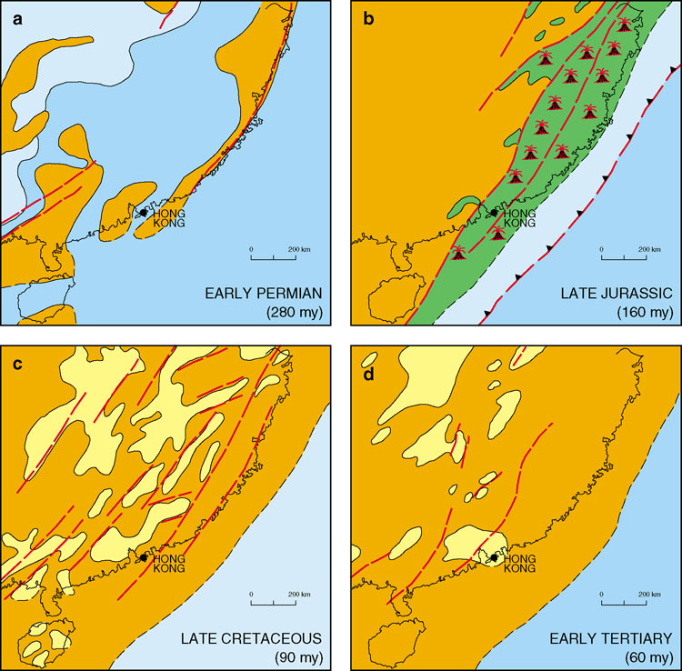
The oldest rocks in Hong Kong were deposited as sediments on alluvial floodplains, in intertidal deltas and in a shallow continental sea, during the late Palaeozoic (Figure 2.5c). These Devonian sediments are likely to have originated from erosion of a continental landmass which once lay to the southeast of Hong Kong before its detachment and migration during the Permian to Jurassic. Continued submergence and deepening of the offshore basin led to deposition of carbonaceous silt and mud and later, shelf carbonates (Figure 2.5d). These are now preserved in Hong Kong as Carboniferous siltstone, mudstone and marble. A deep marine environment then developed as sea-level continued to rise. This is represented by fossiliferous siltstones and mudstones of Early Permian age (Figure 2.6a). A major period of uplift and erosion, accompanied by intrusion of granites, is thought to have occurred throughout eastern China during the Triassic. In Hong Kong, this tectonic event is recorded solely by an intrusion of granite in Deep Bay. Following this event, a shallow marine environment developed during the Early Jurassic followed by gentle uplift and the beginning of a major episode of volcanic - plutonic activity. Widespread volcanism and plutonism occurred throughout southeastern China from the Middle Jurassic to the Cretaceous (Figure 2.6b). This is represented in Hong Kong by thick accumulations of pyroclastic material and voluminous granitic intrusions. Following cessation of this igneous activity in the Early Cretaceous, the volcanic pile was extensively eroded and deposition occurred in northeast-trending intermontane basins (Figure 2.6c). In Hong Kong, thick 'red-bed' conglomeratic sequences of Early to Late Cretaceous age indicate that the climate was probably hot and dry. In the early Tertiary (Figure 2.6d), a particularly arid climate ensued with the development of evaporitic deposits in intermontane basins. There is no further stratigraphic record preserved in Hong Kong until the Quaternary, when thick non-marine and marine deposits accumulated in low-lying areas.
Lianhuashan Fault Zone
The Lianhuashan Fault Zone is one of the dominant structural features of southeastern China and consists of subparallel and anastomosing, northeast-trending faults. In Guangdong Province the fault zone is up to 30 km wide (Bureau of Geology and Mineral Resources of Guangdong Province (BGMRGP, 1988) and is characterised by numerous ductile shear belts, some of which are associated with local medium to high grade dynamic metamorphism (Yang, 1996).
Hong Kong lies at the southwestern extremity of the Lianhuashan Fault Zone, where it is bounded by the Shenzhen Fault to the north and the Haifeng Fault to the south (Chen, 1987; Lai & Langford, 1996) (Figure 2.3). The most intense activity along the fault zone was during the Mesozoic when structurally controlled Late Jurassic to Early Cretaceous volcanic and plutonic centres were developed; later substantial sinistral displacement resulted in the formation of small transtensional basins.
It has been postulated that the Lianhuashan Fault Zone is the surface expression of a deep-seated suture within the Precambrian basement rocks. Evidence for this lies in the isotope signatures of the exposed Mesozoic granite plutons that have sampled the crustal rocks beneath Hong Kong (Darbyshire & Sewell, 1997; Davis et al., 1997) and the modelling of the regional gravity data (Fletcher et al., 1997). These results suggest that the suture separates terranes of predominantly Archaean and Proterozoic rocks that probably amalgamated in Proterozoic times. Whether the suture formed during the subduction of oceanic crust between two converging plates, represents a major strike-slip fault between two continental fragments, or is the margin of a Proterozoic greenstone belt remains unclear. However, once formed, it largely controlled the geological development along the Lianhuashan Fault Zone throughout the Phanerozoic.
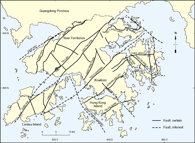
Faults of Hong Kong
The main fault orientations in Hong Kong strike eastnortheast, varying to northeast, and northwest, varying to northnorthwest. Some authors (e.g. Lai & Langford, 1996; Ding & Lai, 1997) regard northeast- and eastnortheast-, varying to east - west-striking faults as belonging to different subsets. The east - west faults include both low-angle and subvertical faults. Occasional north-south striking faults also occur. The general pattern of faults in Hong Kong is similar to the regional pattern seen in Guangdong Province (BGMRGP, 1988).
Individual faults within Hong Kong can be traced for up to 60 km and are associated with zones of more generally brittle - ductile deformation up to 1 km wide. They form many of the major northeast-trending valley systems in Hong Kong (Plate 1.2). However, most faults intersected in boreholes or tunnels appear to be only metres wide and in a few places, tens of metres wide at the most.
In many instances, more than one name has been used for individual faults in Hong Kong. In part, this has resulted from faults having been mapped and described on a local basis before their lateral extent was fully realised. Also, it has been common practice in Hong Kong to use more than one geographical name to identify faults and fault zones and this has often resulted in cumbersome names. A proposed rationalisation and simplification of the fault nomenclature is presented in Figure 2.7.