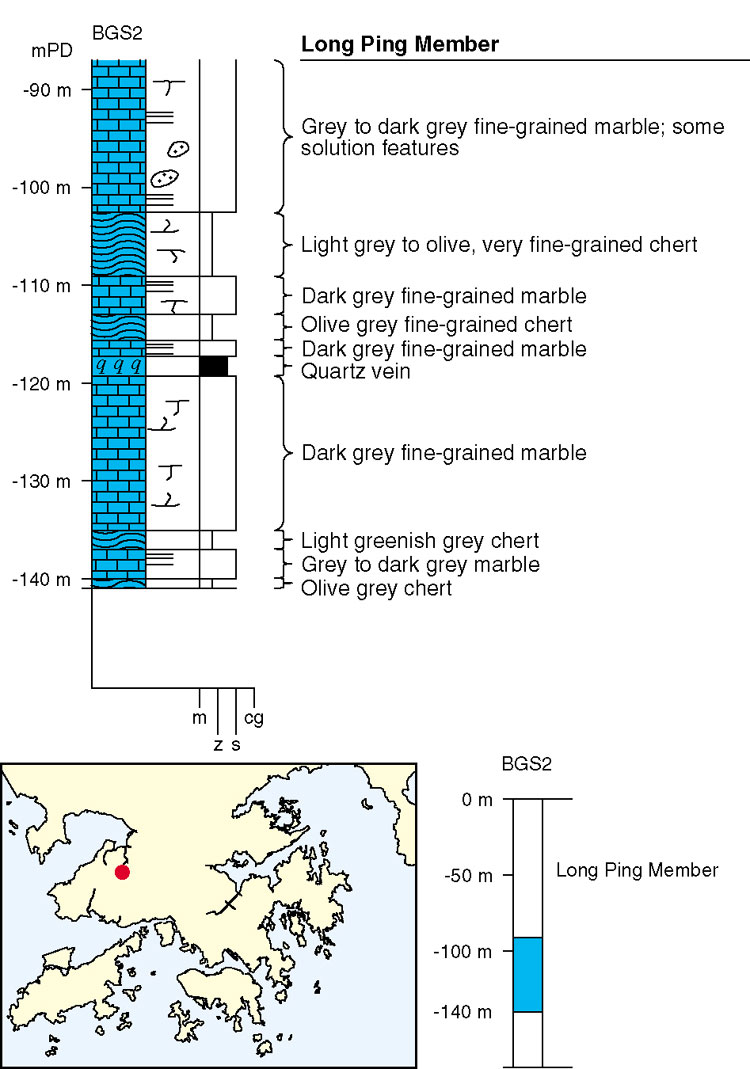
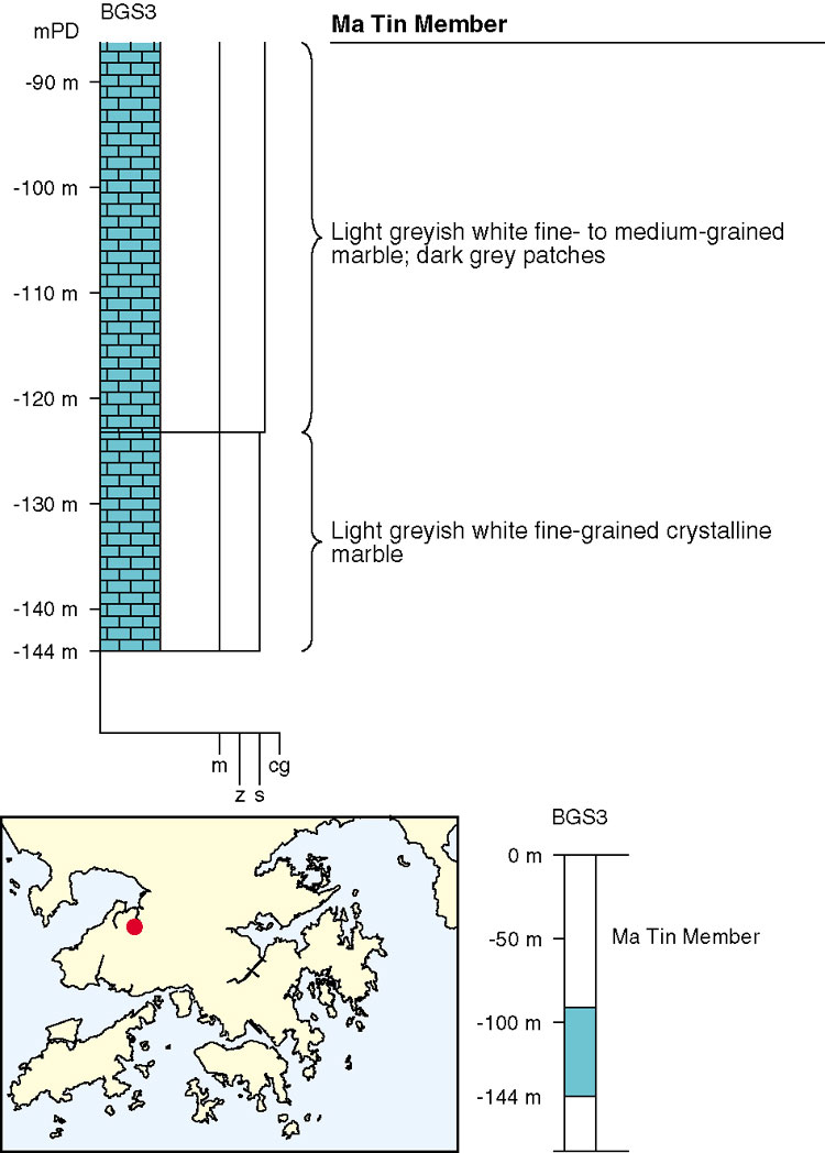
The Yuen Long Formation was first encountered in boreholes and caissons during development of the new town of Yuen Long, in the northwest New Territories (Langford et al., 1989; Frost, 1992). It has not been possible to date the marble sequence palaeontologically in Hong Kong. However, similar carbonate sequences are found in southern China (Huang, 1978; Bennett, 1984) and these are interpreted as Early Carboniferous in age (Lai & Mui, 1984). In the Yuen Long area, Frost (1992) divided the formation into two members: the lower Long Ping Member is a dark grey marble, commonly with complex internal structure, while the upper Ma Tin Member is a massively bedded, white marble. The thickness of the Yuen Long Formation in the type area is around 600 m (Frost, 1992) although elsewhere in Hong Kong, thicknesses are less well constrained (Busby & Langford, 1995). On the basis of steep dips in the overlying, tightly folded Mai Po Member, the marble probably reaches a similar thickness on The Brothers islands (Langford et al., 1995). Frost (1992) has designated the type sections of the Long Ping and Ma Tin members respectively as boreholes BGS2 and BGS3 (Figures 3.6 & 3.7). In some areas, and especially on the north coast of Lantau Island, the marble exhibits skarn mineralization with diopside and garnet in a matrix of interstitial granular calcite. The presence of skarn mineralization suggests that igneous rocks lie nearby at depth.
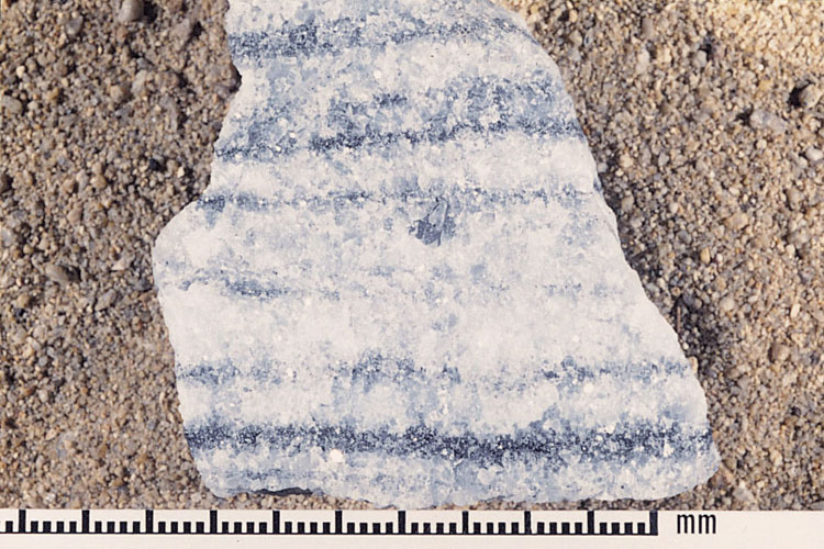
The Long Ping Member dominantly comprises grey to dark grey fine- to medium-grained crystalline marble with minor chert (Plate 3.5). Stylolitic structures indicate dissolution at grain boundaries (Yuen, 1990). Metamorphism has been both thermal and regional. The original rocks are considered to have been an interbedded sequence of thin limestones, and calcareous mudstones and siltstones (Frost, 1992). The dark colour is caused by the content of mainly fine silt clasts, which typically make up 8% of the rock. This clastic component varied with the supply of terrigenous sediment into the original sedimentary basin in which the calcareous strata were deposited. Other lithologies, including sandstone (now chert), graphitic siltstone, and dolomite, occur within the Long Ping Member. The dolomite is thought to represent periods of partial shallowing of the basin.
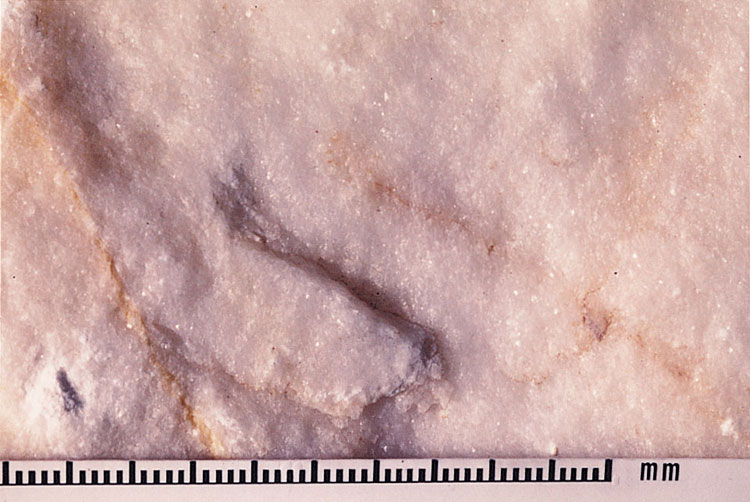
In contrast to the dark clastic-rich carbonates of the Long Ping Member, the Ma Tin Member comprises massively bedded, pure, white to greyish white, medium- to coarse-grained crystalline marble, comprising over 99% calcium carbonate (Plate 3.6). Sporadic solution features (see below) and boxwork structures are common (Yuen, 1990). Accessory minerals include dolomite, tremolite, epidote and wollastonite. The metamorphic grade is therefore considered to have had both a thermal and regional component. The original limestone has been entirely recrystallized and any traces of sedimentary structures have been completely destroyed (Frost, 1992). In the same way, there are no indications of the preservation of fossils and microfossils.
The top of the marble comprises a zone of karstic development with an uneven and pinnacled surface (Figure 3.8), as well as cavities within the rock mass. Acidic rainwater has produced a 30 m-thick zone of epikarst, a very irregular karstic development comprising uneven solution features. Cavities also occur beneath this zone. The presence of palaeokarst beneath Yuen Long has caused significant engineering problems in the development of the new town (Holmes & Keung, 1990), especially in relation to foundation design and construction. Similar complex ground conditions have been encountered in developments to the north and south of Yuen Long at Pak Hok Chau and Tai Tong respectively, and more locally to the west of Yuen Long at Tin Shui Wai.
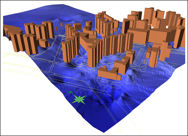
Marble encountered in boreholes on the reclamation at Ma On Shan (Figure 3.9), and in the Ma On Shan mine, has been assigned to the Ma On Shan Formation (Frost, 1991; Sewell, 1996). Detailed petrographic study of the Yuen Long and Ma On Shan formations concluded that there are no discernible differences between the two marbles.
Details
Southeast Yuen Long. The largest subcrop of the formation has been revealed by more than 700 boreholes in the area from Ying Lung Wai (822000 834000 Csy-1) to south of Lung Tin Tsuen (820200 832400 Csy-2). Fresh marble is buried 18 to 43 m below the surface, with a highly irregular rockhead or karst surface consisting of pinnacles and slots. The Yuen Long Formation forms an anticline, with metasiltstones and graphite schist of the Mai Po Member on both limbs. The southeast limb is cut by a northeast trending fault, so the Mai Po Member on that side forms only a narrow strip. The rock type is mainly white and pale grey marble; dolomitic marble and thin layers of metasiltstone and metasandstone occur near the top, while the lower part is dominated by black, banded marble. At a site on Sai Ching Street (821000 833500 Csy-3) a 1.4 m thick siltstone is intercalated with the marble, and at a site on Ma Tin Road (820600 833500 Csy-4) a siltstone lens 0.3 to 0.7 m thick and a thin layer of fine grained sandstone 1.8 m thick were found in the marble sequence. An unmetamorphosed gabbro dyke about 0 m wide cuts the marble on this site.
Solution cavities are preferentially developed along discontinuities within the marble. The greatest development of cavities in the marble has been reported in a site between Ying Lung Wai and Castle Peak Road (821700 834000 Csy-5). According to the borehole logs, the commonest cavities are from 0.1 to 2 m in height fewer range from 5 to 15 m, but the largest cavity is 24. 6 m in height; most cavities have been encountered above 70 mPD.
Most of the cavities so far encountered in southeast Yuen Long are less than 1 m in height, a few reach 2 to 3 m or occasionally 8 to 10 m. Generally the cavities contain deposits of brown laminated clayey silt with weathered rock fragments. In small areas of Yuen Long, deep boreholes into the marble have proved free of cavities.
Fairview Park to Lok Ma Chau. Two subcrops occur in Fairview Park, one along the northwest boundary (822400 838400 Csy-6 to 822400 838300 Csy-7), the second within the estate (822500 838200 Csy-8 to 822600 838000 Csy-9). The marble occurs 20 to 58 m below the surface, and consists of white to dark grey, fine to medium grained marble, with some dolomitic marble. In one borehole B182 (822460 837530 Csy-10) the marble has been thrust over the graphite schist of the Mai Po Member.
Boreholes northwest of Lok Ma Chau (825900 841700 Csy-11) proved the Yuen Long Formation 25 m below the surface beneath 11 m of superficial deposits and 14 m of metasiltstone of the Mai Po Member. The marble is greenish grey and rich in manganese.
North and West Yuen Long. The Yuen Long Formation was found in boreholes in Yuen Long Industrial Estate (820500 835600 Csy-12). Within the Estate the white marble, interbedded marble and metasiltstone were found in boreholes. The white marble is confined to the southeast, while the interbedded succession was found at depth in the southwest. Metagranite and metagranodiorite cut the marble close to the line of a westnorthwest trending fault which passes through the centre of the Estate.
The Yuen Long Formation occurs 30 to 55 m below ground surface beneath the metamorphosed sandstone and siltstone of the Mai Po Member at the Long Ping Estate (820500 834300 Csy-13). In a number of places in Yuen Long town centre, boreholes have penetrated the Mai Po Member to intersect the marble. Such occurrences have been found west of Tai Kiu (820500 834100 Csy-14) and on Castle Peak Road (820800 833800 Csy-15); the Yuen Long Formation underlies the Mai Po Member some 23 to 68 m below the surface.
The Yuen Long Formation was found in boreholes west of Shui Pin Wai (819700 833800 Csy-16) and to the west of Lam Hau (819600 833000 Csy-17) along the Shan Ha Road. The formation is mainly composed of pale grey to white, fine to medium grained marble and is concealed by a layer of superficial deposits of between 18 and 40 m thickness. Metasandstone of the Mai Po Member occurs on the both sides of the marble, forming low rounded hills. From this disposition of the formations a thrust faulted structure is inferred. A basalt dyke trending 050o intrudes the marble west of Lam Hau (819650 833130 Csy-18).
Tin Shui Wai. The formation occurs north of Tin Shui Wai (819100 836700 Csy-19) and northeast of the Ha Tsuen San Wai (818500 834800 Csy-20), where it is covered by a 23 to 28 m thick sequence of marine and alluvial deposits. The marble forms an intermittent subcrop along an inferred anticline axis. Some thin layers of metasiltstone are intercalated in the formation in this area and the marble is also intruded by a rhyolite dyke. To the west of Sheung Cheung Wai (818600 834100 Csy-21) and to the east of Ha Tsuen (817800 834100 Csy-22) the Yuen Long Formation underlies metamorphosed siltstone and sandstone of the Mai Po Member 28 to 47 m below the surface.
Ma On Shan Formation
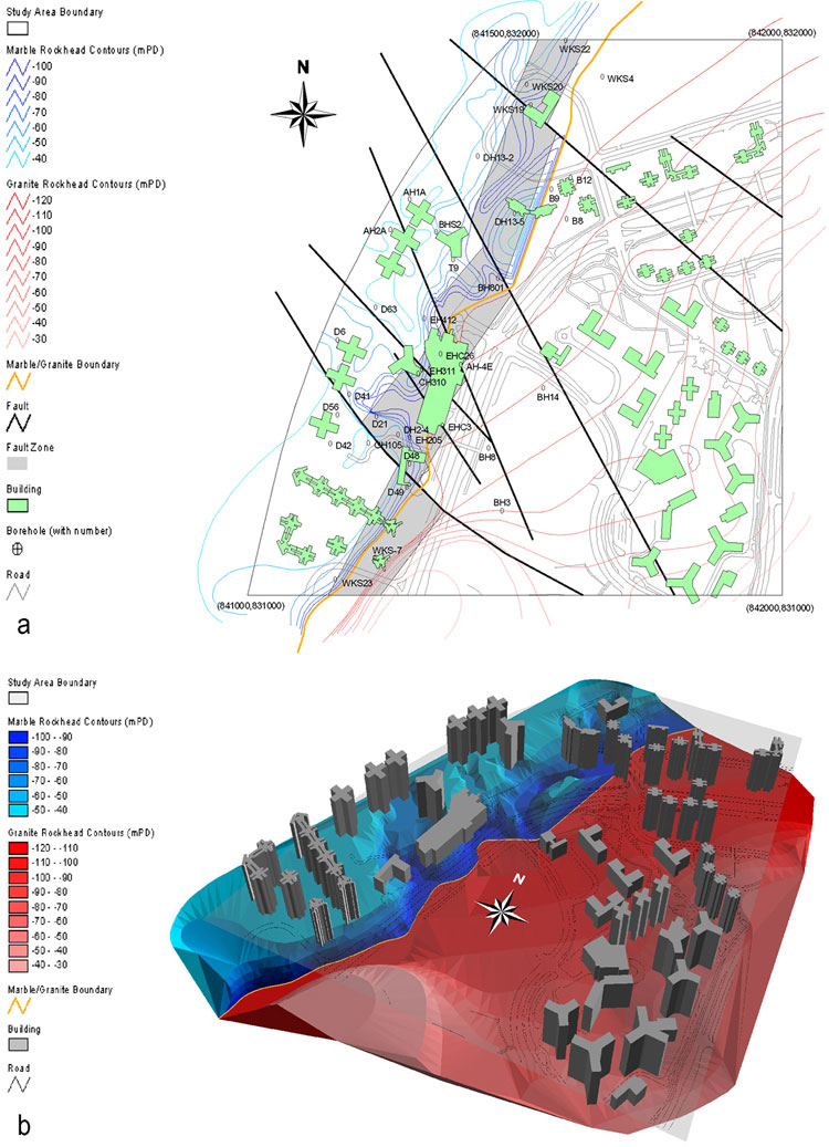
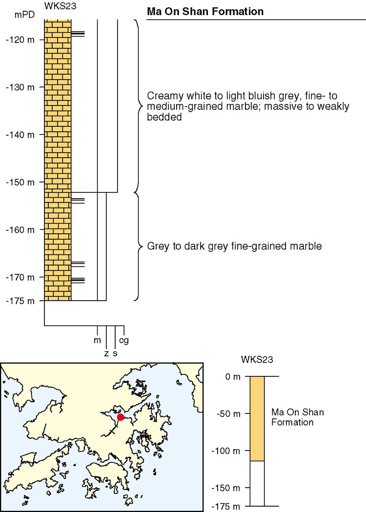
Marble encountered in boreholes (c. 841380 831620 Csy-23) on the reclamation at Ma On Shan (Figure 3.9), and in the Ma On Shan mine, has been assigned to the Ma On Shan Formation (Frost, 1991; Sewell, 1996). The marble consists of bluish grey to creamy white, dolomite to calcite marble with thin (<10 mm) interbeds of dark green metasiltstone and is steeply dipping (70 - 80o) to the southeast. The type section of the Ma On Shan Formation is defined here as Borehole WKS23 from the Ma On Shan Reclamation (Figure 3.10). Little is known of the subsurface outcrop of the marble in the surrounding area. However, two boreholes (c. 842880 834570 Csy-24) in Tolo Channel, 500 m southwest of Harbour Island, intersected dolomitic limestone at a depth of 25 m below the seabed (Wong & Ho, 1986). Geophysical surveys have suggested that slivers of marble may also underlie other parts of Tolo Harbour (EGS, 1991).
The Ma On Shan Formation has a minimum thickness of 200 m. No fossils have been recovered from the marble and contact relationships with other formations are not known. In a detailed petrographic study of the Yuen Long and Ma On Shan formations, Field and Smale (1991) concluded that there are no discernible differences between the two marbles. Cavities in the marble at Ma On Shan indicate a zone of epikarstic development similar to that at Yuen Long and the karstic top of the marble is locally very uneven (Figure 3.9) (Frost, 1991; Sewell, 1996) which has caused significant engineering problems in the development of the new town.