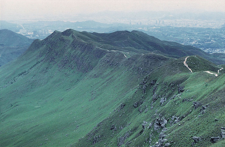
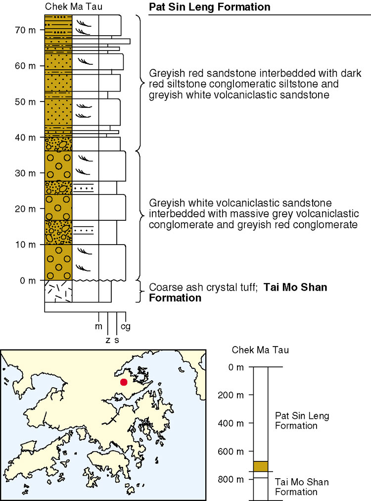
The Pat Sin Leng Formation crops out mostly on the mainland of Hong Kong, in the northeast New Territories. There, it forms a prominent north-dipping escarpment along Pat Sin Leng from Wong Leng in the west to Kwun Yam Tung in the east (Plate 8.1). The formation is thought to be Early Cretaceous (Lai et al., 1996) and rests unconformably on volcanic rocks of the Tai Mo Shan Formation in the southeast, but is overthrust by these same rocks in the north. The formation has a maximum exposed thickness of 500 m and covers an area of some 30 km2. The designated type section is at Chek Ma Tau (Figure 8.2).
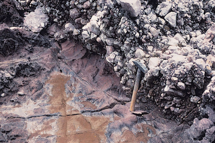
The Pat Sin Leng Formation varies from grey to greyish white, thickly-bedded conglomerate, tuffaceous sandstone, and reddish brown thinly-bedded siltstone in the lower part, through greyish red sandstone and occasional conglomerate in the middle part, to reddish purple, clayey siltstone with sandstone in the upper part. Subround to subangular pebbles, cobbles and boulders mostly comprise red and brown volcanic rocks (Plate 8.2).
Jones (1995) described two main types of deposit at Bluff Head: channel-fill and sheetflood deposits. The channel-fill comprises conglomerates, forming erosively-based units up to a few metres thick, and pebbly sheet sandstones and siltstones. The conglomerates are poorly sorted and matrix supported, with clasts of mainly volcanic granules, intraformational mudstone clasts, and less commonly red sandstone and grey volcanic clasts. The conglomerates form fining-upward sequences. These pass into the sheetflood deposits composed of sheet-like sandstones, up to 0.4 m thick, and siltstones with dessication cracks and intense bioturbation.
Details
The formation has largely been removed by erosion at Hsien Ku Fung (842150 838370 Kp-3), and to the west, only a few outcrops remain as outliers on peaks such as Shun Yeung Fung (841100 838560 Kp-4) and Lai Pek Shan (840230 838940 Kp-5). The scarp from Wong Leng (839460 838840 Kp-6) to Nam Shan (837440 839880 Kp-7) marks the unconformable contact with the underlying Tai Mo Shan Formation. Further to the north, fault-bounded isolated outcrops occur 500 m east of Tan Chuk Hang (837100 841300 Kp-8), west of Nam Chung (839000 842600 Kp-9), and along the beach between Wu Shek Kok (840000 843900 Kp-10) and Pok Tau Ha (839600 843500 Kp-11). On the hill top (839000 842800 Kp-12) west of Nam Chung the strata are less than 40 m thick and dip to the southeast. To the north (839400 841500 Kp-13, 840000 841300 Kp-14, 840500 841600 Kp-15), three very deeply-dissecting streams locally expose the underlying tuff.
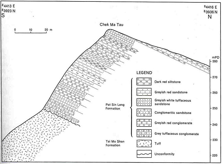
Chek Ma Tau to Tiu Tang Lung. From Bride's Pool (842480 840380 Kp-1) east to near Hung Shek Mun (847400 839700 Kp-16) the formation is up to 500 m thick (Figure 8.A1). The basal strata are characterized by a 25 m thick conglomerate and sandstone unit which caps the hill top and forms a lengthy, steep cliff on the south side of the slope. Higher in the sequence, sandstone predominates, with subordinate tuffaceous sandstone and greyish red clayey siltstone, and there is a gradual transition upwards into greyish red clayey siltstone with sandstone.
A typical profile of the lower strata exposed at Chek Ma Tau (844100 839280 Kp-17) is presented in Figure 8.A1. The sequence is 64.5 m thick and sedimentary cyclicity is evident. Each of the 11 cycles, where complete, includes conglomerate, sandstone and siltstone. The base of the formation comprises mainly pinkish grey, very thick, tuffaceous conglomerate and very light grey or pale red tuffaceous sandstone. Overlying rocks include reddish siltstone which in each cycle are 1 to 3 m thick.
In the middle of the formation, near Sheung Miu Tin (844700 840300 Kp-18), sandstone predominates, with subordinate tuffaceous sandstone and greyish red, clayey siltstone. Strata from the upper part of the southern slope of Tiu Tang Lung (844700 841200 Kp-19) comprise 120 m of thick, greyish red to reddish, clayey siltstone with four beds of greyish white to reddish purple sandstone, 0.5 to 1 m thick. To the north, thrusting along the Tiu Tang Lung Fault has caused repetition of strata and the development of minor folding at Wu Kau Tang (843700 840700 Kp-20).
Tai Tung to Sam A Tsuen. The lower part of the formation is exposed between Tai Tung (846200 839500 Kp-21) and Kwun Yam Tung (846930 839790 Kp-22) and consists of 26 m of very thickly bedded pinkish grey to light grey tuffaceous sandstone with conglomerate and a subordinate siltstone. This passes upwards into a sequence dominated by sandstone with siltstone and conglomerate at Sam A Chung and then into siltstones from Sam A Wan (846300 841500 Kp-23) to Sam A Tsuen (846000 842100 Kp-24). The strata are steeper in the south, dipping at 35o to the north, compared with dips of 17o to the northeast in the central part of the basin at Sam A Chung (845600 840700 Kp-25). At Au Yue Tsui (846720 841560 Kp-26) and north of Ma Niu Shui, the sequence is thrust-faulted and is repeated north of the thrust plane.
Fung Wong Wat Teng to Wu Chau. The strata to the north of Fung Wong Wat Teng (849700 839700 Kp-27) are approximately 350 m thick and have been intensely eroded. On the sea shore opposite Wu Chau (849300 840100 Kp-28), underlying yellowish grey tuff with a 20 mm-thick, brick red weathered zone is exposed and is overlain by reddish brown conglomerate of the Pat Sin Leng Formation. The proximity of northeast-trending faults parallel to the coastline has led to a steepening of the bedding on the south shore of Wong Chuk Kok Hoi and dips up to 45o to the north are recorded. At Wong Wan Sai Teng (849000 840800 Kp-29), tuff of the Tai Mo Shan Formation is thrust over the Pat Sin Leng Formation.
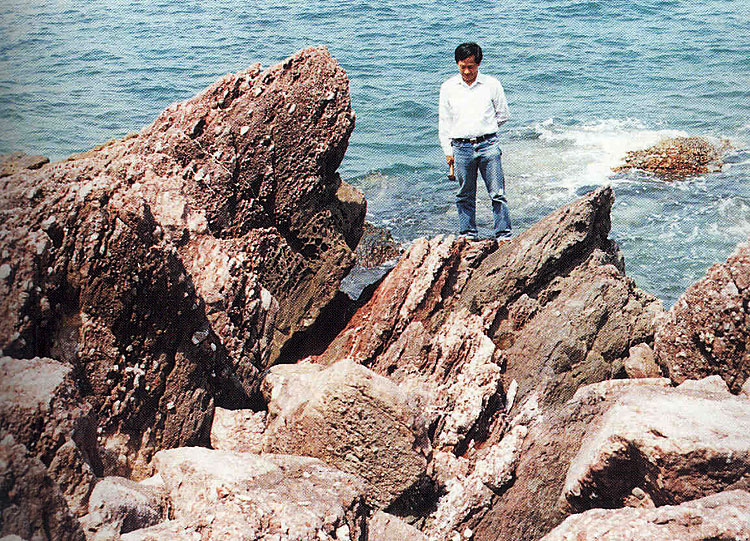
Pak Kok Shan to Wong Wan Chau (Double Island). The strata on the peninsula from Pak Kok Shan to Wong Chuk Kok Tsui (Bluff Head) are cut by northeast and northwest-trending faults forming a series minor fault blocks. The strata become very steep and are even overturned adjacent to the southeastern marginal fault. The formation here is relatively thin, and the underlying tuff is exposed at Wong Chuk Kok Tsui (Bluff Head) (852440 841300 Kp-30, Plate 8.A1), Shek Tsai Wan (851720 840800 Kp-31), the beach northwest of Ngong Chong Shan (851000 840460 Kp-32) and northwest of Pak Kok Shan (850500 840000 Kp-33). The formation at and west of Wong Chuk Kok Tsui comprises conglomerate, sandstone, and mudstone. The conglomerate has subangular to rounded clasts up to 150 mm across, with some intraformational mudstone clasts. The sandstone is poorly sorted, fine to coarse-grained, cross-bedded with poorly-developed small-scale channels. On Wong Wan Chau, the northern limit of the formation is marked by a thrust zone and is overlain by tuff of the Tai Mo Shan Formation.