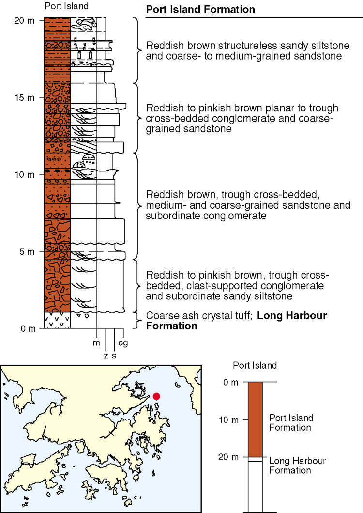
The Port Island Formation, which is interpreted as Late Cretaceous (Lai et al., 1996), is only exposed on small islands in Mirs Bay including Port Island, Round Island, Channel Rock and Shek Ngau Chau. The formation dips moderately (30º) to the east and southeast and unconformably overlies coarse ash crystal tuff of the Early Cretaceous Long Harbour Formation. Possible correlatives of the Port Island Formation have been recognized at Xiasha on the eastern side of Mirs Bay (Lai et al., 1996). The formation is also present in several marine boreholes, and is evident on seismic reflection profiles, in Mirs Bay (Fyfe et al., 2000). The formation is, therefore, thought to underlie much of Mirs Bay, and is estimated to be more than 1200 m thick. Ruxton (1960) described the type section of the formation from the southern tip of Port Island (Figure 8.3).
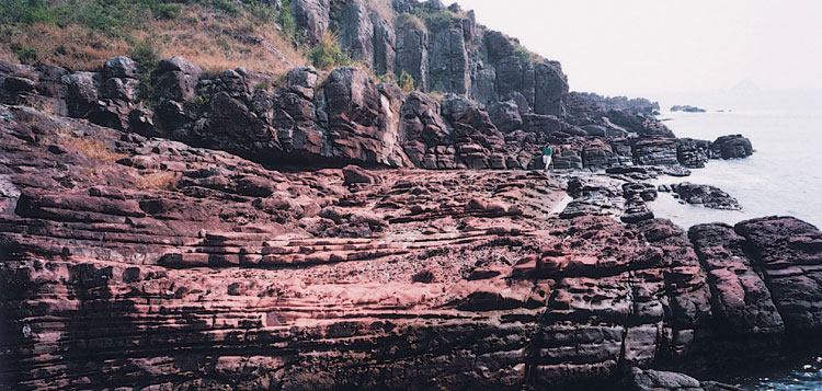
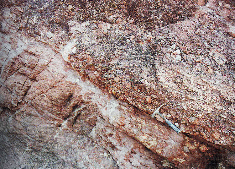
The Port Island Formation comprises mainly very thickly- to thickly-bedded, reddish brown conglomerate and sandstone, with interbedded thickly- to thinly-bedded siltstone (Plate 8.3). It is distinguished from the Pat Sin Leng Formation by having a less varied suite of clast types and in possessing conglomerates that are clast supported as opposed to matrix supported (Jones, 1995).
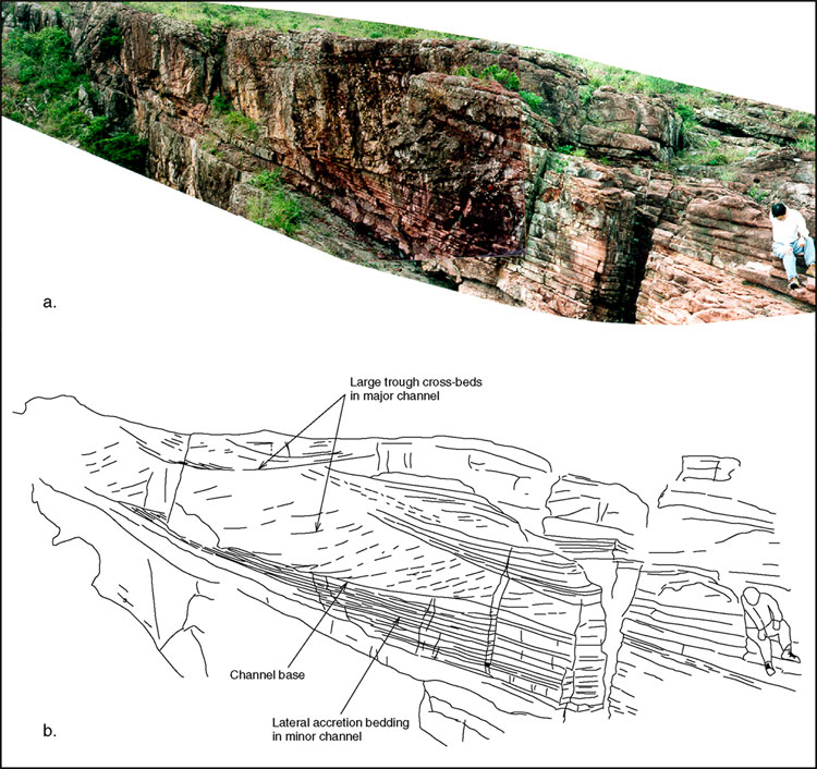
Two main facies have been recognized in the Port Island Formation (Jones, 1995): a channel facies and a floodplain facies. The channel facies (Plate 8.4) is dominant and is represented by major and minor channels. Major channel infills are between 3 and 6 m thick, and comprise reddish to pinkish brown, clast-supported conglomerate, and subordinate sandy conglomerate and pebbly sandstone. Trough cross bedding is the main sedimentary structure. Individual cross bedding sets vary from 0.3 to 3 m thick, and have a distinctive concave-upward base. Palaeocurrents measured from cross bedding sets indicate flows towards the eastsoutheast. Minor channels generally range from 2 to 4 m thick and they typically occur one above another. They also often overlie major channels. The minor channels are infilled with reddish to pinkish brown medium- to very coarse-grained sandstone, and very minor conglomerate. Small-scale cross bedding and faint parallel lamination may be present, but in general, sedimentary structures are uncommon. Each minor channel contains bedding that typically dips at a low angle (<10º). The sandstone beds are laterally continuous, vary from 0.1 to 0.4 m thick and often taper or thin down-dip.
The floodplain facies comprises three main types of deposit: sandy siltstone, siltstone with calcrete, and sheet sandstone. Sandy siltstone forms beds up to 0.8 m thick, composed of reddish brown, coarse-grained siltstone to fine- to medium-grained sandstone. The sandy siltstone commonly contains sand-filled cylindrical burrows and, in places, rare dessication cracks. Siltstone with calcrete is relatively uncommon and comprises horizons of reddish brown structureless siltstone and sandy siltstone, up to 20% of which comprises white calcium carbonate nodules. These may occur as irregular spheres, filaments and rods. Sheet sandstones are up to 0.2 m thick. They consist of reddish brown, medium-grained sandstone, forming laterally continuous beds with sharp bases. Vertical burrows may be present.
Details
Chek Chau (Port Island) to Kung Chau. The type locality of the formation forms the outcrop on the eastern coast of Chek Chau. An 8 m-thick conglomerate and conglomeratic sandstone overlies tuff of the Long Harbour Formation, dipping 30o to the east-northeast (Plate 8.A2). The overlying rocks are mainly very thickly to thickly bedded, reddish sandstone. Underlying the unconformity, a 10 to 12 m-thick, dark reddish brown, weathered tuff is exposed on both sides of Hung Ying Tsui (854880 839760 Ki-1, 855000 839700 Ki-2) and on the north coast of the island at Lau Shui Hang Tam (855180 840560 Ki-3). Some subrounded pebbles, similar to those in the overlying Port Island Formation, are embedded in the weathered tuff, suggesting that the tuff was still not lithified when the conglomerate was deposited. The remainder of the formation comprises mainly interbedded, very thickly to thickly bedded conglomerate and sandstone with thickly to thinly bedded, reddish siltstone. The strata are cut by normal faults trending east-northeast and west-northwest. At low tide, reefs are exposed at Cham Pai (Channel Rock) (855560 838960 Ki-4) and to the northeast (856260 838330 Ki-5) of Kung Chau, and comprise reddish brown conglomerate and conglomeratic sandstone, dipping 25o to the northeast. The western side of a submarine rock high (855300 839000 Ki-6) has been interpreted from seismic data (line D5, fix 2250) as a fault between the Port Island Formation and tuff. This is shown on a cross-section on Sheet 4, but is now thought more likely to represent a scarp formed by a change in lithology, similar to that on Port Island itself where an unconformity is clearly visible.
Pak Sha Chau (Round Island). The island is situated in the northwest of Tai Pang Wan (Mirs Bay). The lithology in the lower part of the sequence, in the southwest of the island, is a dominantly reddish brown, thickly to very thickly bedded, coarse-grained sandstone with conglomerate. In the northeast of the island, the upper part of the sequence comprises interbedded coarse-grained sandstone and conglomerate, dipping 30-40o to the east-northeast and southeast. Depositional cycles, including conglomerate and sandstone, vary from 30 to 50 mm. Two sets of faults are developed: one trending 320o , parallel to the southwest coast, containing fault breccia and dipping 60-80o; the other trending 340o and dipping 75-85o , forming large fault scarps. Proximity to faults explains the very steep to locally overturned bedding in the northeast of the island.
Shek Ngau Chau to Breaker Reef. The formation on these islands in the southern part of Tai Pang Wan (Mirs Bay), comprises reddish brown conglomeratic sandstone and fine to coarse-grained sandstone with conglomerate dipping at 20-26o to the northeast. The strata are cut by minor high-angle normal faults trending 015-128o. Quartz veinlets infill joints along the fault zone.
Tai Pang Wan. Based on interpretation of seismic data and 18 boreholes logs (Geotechnical Information Unit No. 12915), the Port Island Formation extends across most parts of Tai Pang Wan (Mirs Bay) and infills a structure referred to here as the Tai Pang Wan Basin, which is 24 km long and 13 km wide. The main lithologies seen in boreholes are reddish brown siltstone, sandstone and conglomerate. The dip of the sedimentary rocks in the centre of the basin is gentle (14-18o), though near the basin margins is steeper (20-28o). The centre of the basin is located beneath a small Tertiary basin at Ping Chau.