Introduction
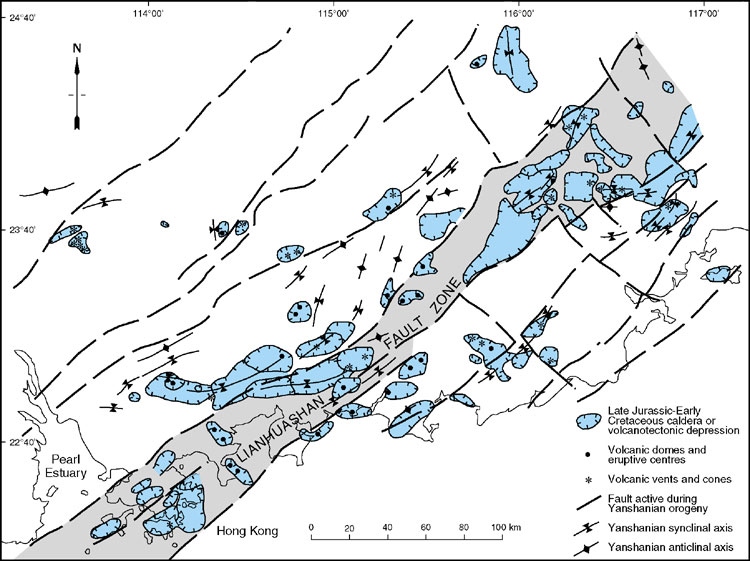
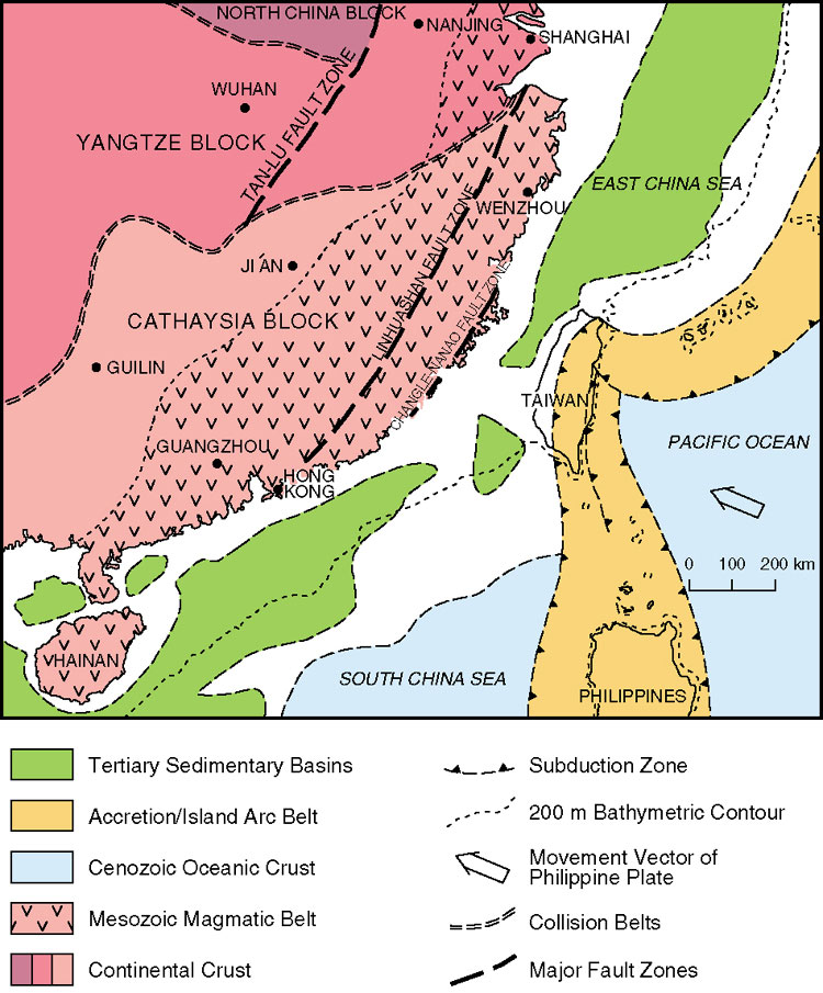
The structural evolution of Hong Kong has included events ranging in age probably from the Precambrian, and certainly from the late Palaeozoic, to the Recent (Table 9.1). However, most deformation that is evident in the rocks of Hong Kong was caused by events that occurred during the Jurassic and Cretaceous, when major volcanic eruptions were accompanied by the intrusion of large volumes of granitic magma into the crust. This episode of magmatism was associated with a period of protracted regional faulting and folding, and these events are collectively referred to as the Yanshanian Orogeny (Table 9.1). In this context, Hong Kong’s location within the northeast-trending Lianhuashan Fault Zone is of particular significance. Evidence of the structural evolution prior to the Yanshanian Orogeny is fragmentary at best and poorly constrained in time, but some inferences can be made even with regard to the structure of the Precambrian crust thought to lie deep beneath Hong Kong. After the Yanshanian Orogeny, the structural evolution of Hong Kong included basin development and reactivation of pre-existing faults. These events can be related both to the Himalayan Orogeny and to extension and sea-floor spreading in the South China Sea during the Tertiary. Major fault activity probably continued in Hong Kong until comparatively recent times, and microseismic activity continues locally even at the present time.
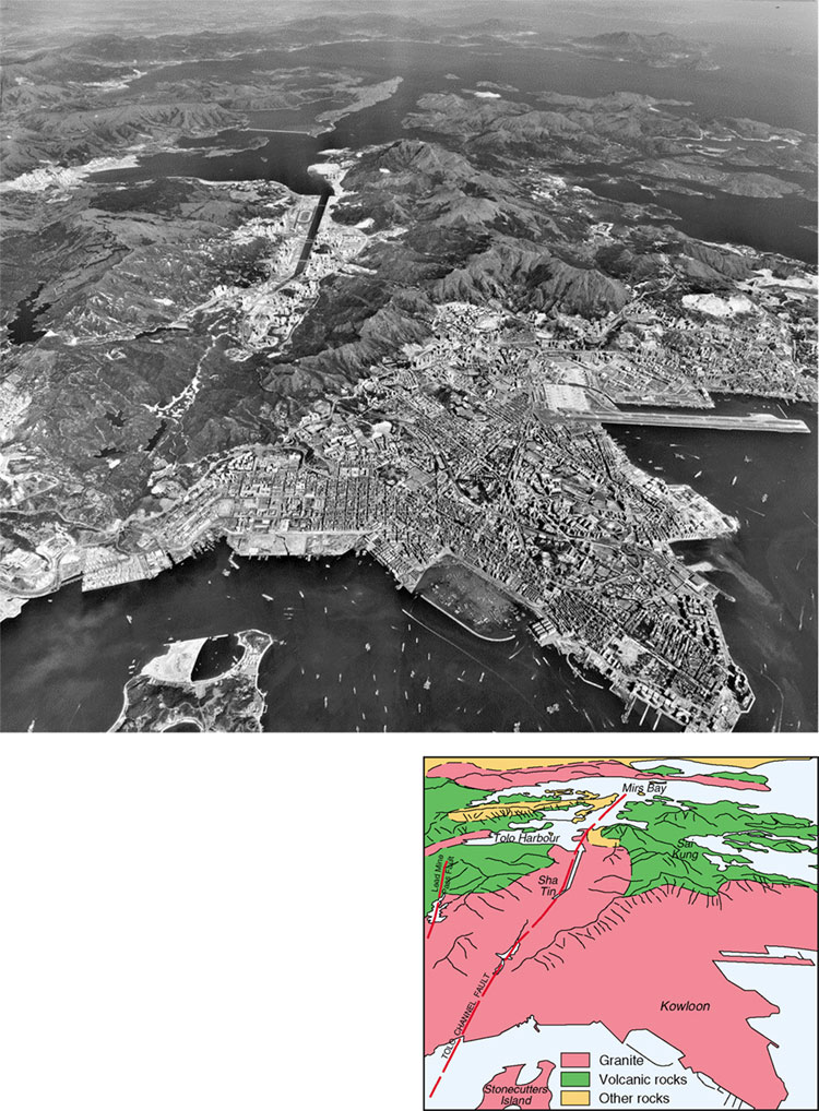
Basement structure of Hong Kong
The Jurassic and Early Cretaceous extrusive and intrusive rocks that crop out over most of Hong Kong largely obscure the pre-Mesozoic geology. No Early Palaeozoic or Precambrian rocks are exposed. However, these deeper rocks are the foundation upon which the younger geology developed, and knowledge of their composition and structure is essential to understand the geology of the surface rocks. Indirect methods have been used to establish the basement geology. Regional geology and tectonic patterns provide a guide to the deep structure, geochemical and isotope signatures of the Mesozoic granites indicate the composition and age of the basement rocks, and models of the subsurface geology can be derived from geophysical surveys.
The regional geology suggests that Palaeozoic rocks underlie at least part of the Mesozoic sequence in Hong Kong. This is substantiated by the presence of marble clasts, thought to be of Carboniferous or in some cases Permian age, within some of the Jurassic volcanic rocks. It is also highly probable that early Palaeozoic and Neoproterozoic rocks are present, based on the palaeo-geographic reconstructions, and exposures of these strata in neighbouring Guangdong Province. Few crystalline Precambrian rocks are exposed in southeastern China, and consequently, there is limited direct knowledge of their composition. However, there is growing geochemical and isotope evidence that both crystalline Archaean and Proterozoic rocks may make up the bulk of the deep crust beneath Hong Kong (Darbyshire & Sewell, 1997, Fletcher et al., 1997). The gravity data from Hong Kong have provided not only a model of the composition of the crust, but also an indication of the locations and orientations of the deep faults.
Gravity models
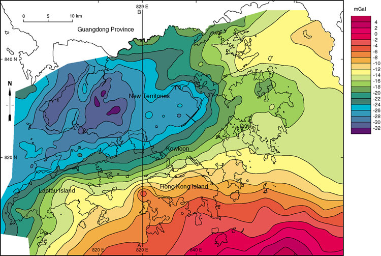
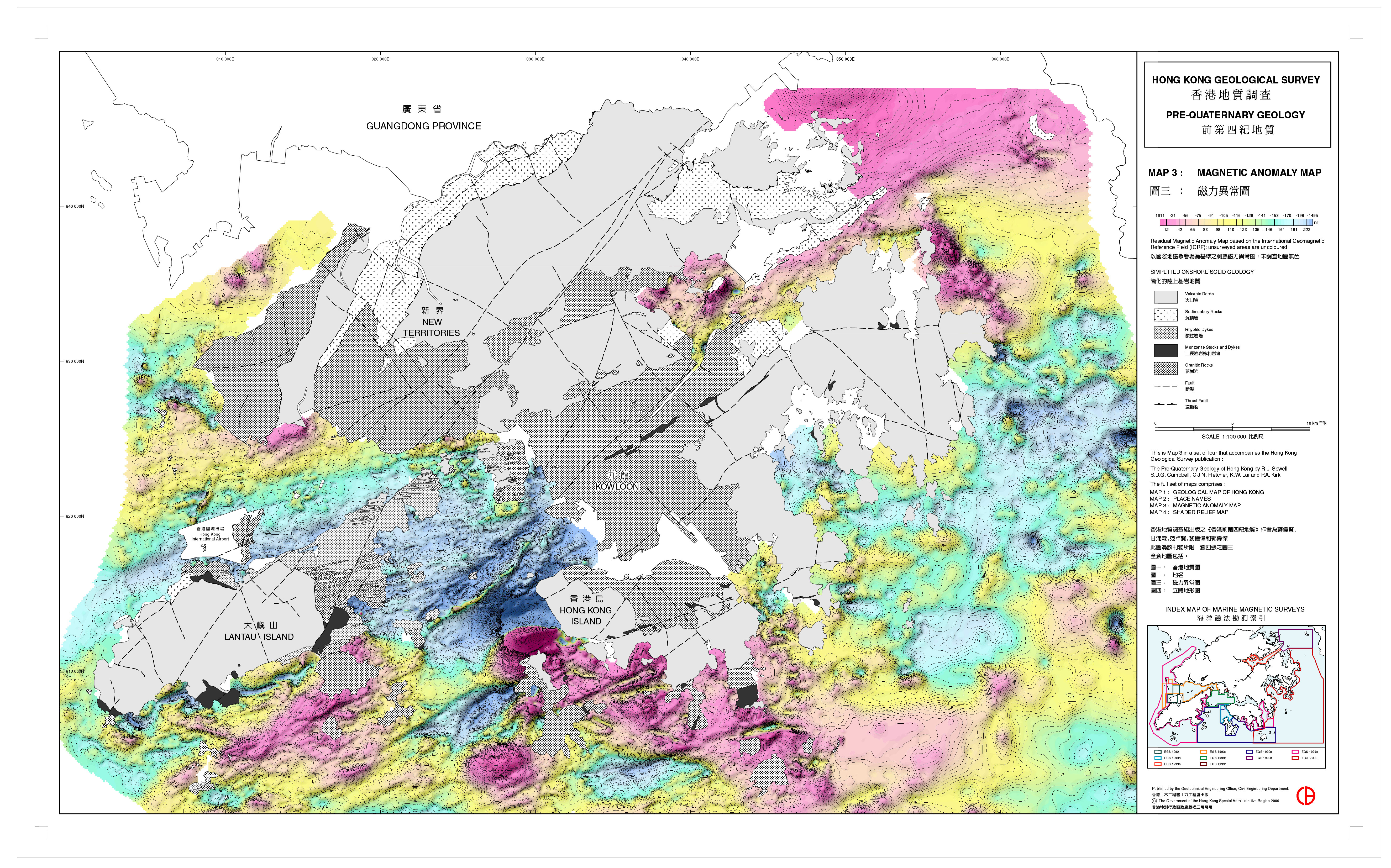
The regional Bouguer gravity anomaly map of Hong Kong (Electronic & Geophysical Services Ltd (EGS), 1991; Busby et al., 1992) (Figure 9.1) displays a steep southeast-trending gradient. This is evident to the southeast of a line extending from Sai Kung in the northeast, through Kowloon to Lantau Island in the southwest. The lowest Bouguer gravity anomaly values, of less than 30 mGal, occur to the south and west of Yuen Long. Values remain below 20 mGal throughout most of the New Territories. Gravity values increase to the southeast and reach a maximum of 5 mGal approximately 15 km to the southeast of Hong Kong Island. There is also a more gradual increase in gravity values towards Mirs Bay in the northeast.
The main steep anomaly gradient cuts both volcanic and granitic rocks, and there is little direct correlation between the gravity anomaly variations and the mapped geology at surface. The western and southern boundaries of the Late Cretaceous and Early Tertiary sedimentary basin that lies offshore in Mirs Bay are not defined by the gravity contours (Figure 9.1), although the basin fill is expected to have a lower density than the surrounding basement rocks. These apparent discrepancies indicate the influence of deep sources and also reflect the limited density contrasts between some of the dominant lithologies: saturated densities of many of the volcanic rock units and the different granite plutons are commonly very similar. Only the low density granites at Needle Hill and on Lamma Island, and the slightly more dense granodiorites are distinctive.
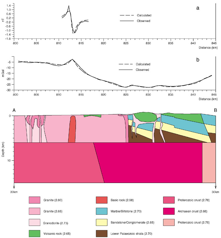
A geological cross-section through the crust has been derived from modelling of the gravity data along grid line 829 E and using data from the existing geological maps (Figure 9.2; Fletcher et al., 1997). The best-fit model for the gravity data consists of a 25 km-wide crustal segment with a density of 2.66 Mg m -3, flanked by blocks with higher densities of 2.76 Mg m -3 to the south and 2.75 Mg m -3 to the north. These densities are consistent with a felsic Archaean crust separating denser blocks of mafic Proterozoic crust. The long-wavelength gravity anomalies, and in particular the southeast-trending gradient that cuts across Hong Kong, appear to result from fundamental discontinuities in the middle and lower crust (6–8 km deep).
Short-wavelength gravity anomalies reflect variations in the geology of the upper crust. Although the largest gravity anomaly, situated to the west of Hong Kong Island (grid line 813 N, Figure 9.1), was defined by only a single gravity station offshore during the regional gravity survey, significant anomalies have been confirmed by more detailed marine magnetic and gravity surveys (see below). The source of both anomalies is interpreted as a basic intrusion that comes to within 230 m of the sea bed (Figure 9.2). Other short-wavelength gravity anomalies (e.g. grid lines 826N and 833N) correlate directly with outcrops of granodiorite, which are slightly more dense than the average granite or the dominant volcanic rocks.
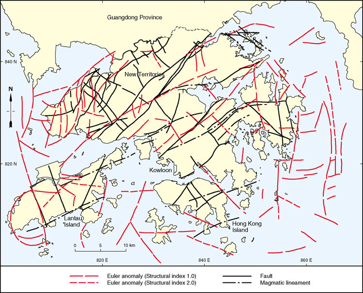
The Euler deconvolution technique has been used on regional gravity data to calculate the locations and depths of the source of the gravity anomalies (Reid et al., 1991). It requires no prior knowledge of geological structure or the physical properties of the rocks, and has been used to interpret deep basement structures (MacDonald et al., 1992; Fletcher et al., 1997).
Euler solutions calculated from the data set for Hong Kong form linear, arcuate and sigmoidal Euler anomalies (Figure 9.3) and have 'solution depths' in the range of 1 to 8 km. The linear anomalies generally vary between 2 and 10 km in length, and are up to 500 m wide. They are considered to represent faults in the upper crust and the uppermost part of the middle crust. Four main sets of subparallel linear anomalies are recognized: a northeast-trending set, more prevalent and continuous in the northwest of Hong Kong; a north-trending set, generally restricted to eastern and western offshore areas; a northwest-trending set, forming short anomalies in the central part of Hong Kong; and an east-trending set concentrated between the north-trending anomalies in eastern offshore areas.
The four sets of anomalies relate to known fault trends in Hong Kong (Figure 9.4). Several anomalies lie on, or close to, mapped faults at surface, suggesting that these structures are vertically continuous through the upper crust. Anomalies not related to mapped faults are considered to represent faults that do not reach ground surface or, in the offshore areas, have not been previously identified. The apparent cross-cutting relationships between the linear anomaly sets are consistent with the general fault chronology based on field mapping. These indicate that the east-trending anomalies are the oldest, followed by the northeast-trending anomalies. Northwest- and north-trending anomalies are the youngest. East-trending anomalies are not common and have Euler solution depths of up to 8 km, which is significantly deeper than any of the solutions on other trends. This would indicate that they are generated from faults in the upper part of the middle crust, and their presence elsewhere has been masked by shallower anomalies. The distinctive sigmoidal anomalies in the northwest of Hong Kong are probably generated from fault duplexes between northeast-trending strike-slip faults. The arcuate anomaly on southwest Lantau Island matches the inferred southwestern margin of the Lantau Caldera (Chapter 5).
Marine magnetic surveys
Marine magnetic surveys have been undertaken over nearly all of Hong Kong's waters (Figure 9.5a) including: south of Chek Lap Kok (EGS, 1992), north of Lamma Island (EGS, 1993a), Tolo Harbour (EGS, 1993b), western waters between Lantau Island and northwest New Territories (EGS, 1993c), the Western Harbour (EGS, 1999a), southern waters between Cheung Chau and the Po Toi Islands (EGS, 1999b) and Mirs Bay (EGS, 1999c). During these surveys, the magnetometer was towed from the stern of a vessel at depths varying between 5 and 10 m. The spacing of the survey lines was generally 200 m, except for the survey in eastern waters where 500 m was used. The surveys have helped in establishing the solid geology of the offshore areas of Hong Kong, and in particular the location of faults as shown on the 1:100 000-scale geological map.
The observed magnetic field is mainly dependant on variations in the magnetic susceptibility of the different bedrock lithologies, remanent magnetism imparted to the rocks at the time of formation, and the degree of weathering. Modelling of the magnetic fields includes reference to the known geology from borehole and onshore information, and defines the probable shapes, orientations and lithologies of the magnetic sources.
The Western Harbour, Lamma Island and Cheung Chau surveys (Figure 9.5, Figure 9.5a) together provide a good example of the value of marine magnetic surveys in mapping the offshore solid geology (EGS, 1993a; 1999a, b, c). There, a northeast-trending linear magnetic trough defines the extension of the Tolo Channel Fault, and a positive magnetic ridge runs parallel to it. The former anomaly is interpreted as a deep weathering zone related to faulting, and the latter to more magnetic monzonite bodies, similar to those exposed in the Sha Tin area (Figure 9.5a). An extension of the east-trending Lantau Dyke Swarm is clearly delineated by magnetic stripes related to magnetic susceptibility contrasts between the feldsparphyric rhyolite dykes and the host Lantau Granite. Displacement of the dykes across the northnorthwest-trending Kap Shui Mun Fault and similarly oriented structures is manifested by the truncation of the linear negative and positive magnetic troughs and ridges. The relative intensities of the magnetic dome and basin to the north of Lamma Island are well displayed. Northeast-trending structures, presumably faults, defined by linear positive anomalies, are recognized to the southeast of Cheung Chau. In addition, a paired magnetic dome and basin is present to the west of Lamma Island. This has a similar orientation to the distinctive anomalies north of Lamma Island and could result from another tabular basic body, perhaps at great depth.
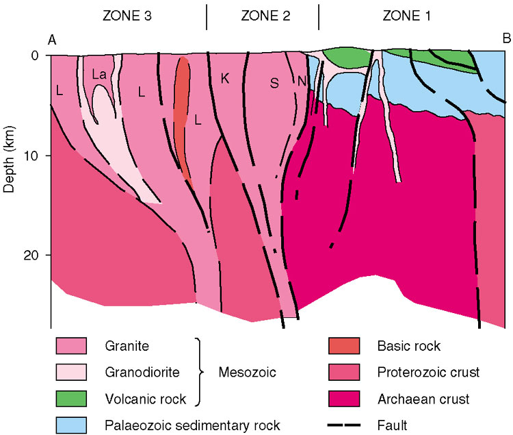
Crustal structure
The proposed crustal structure of Hong Kong (Figure 9.6) consists of a middle to lower crustal element composed of a narrow, northeast-trending felsic segment flanked by more mafic segments, which are considered to represent Archaean and Proterozoic terranes respectively. These are overlain by an upper crustal element, approximately 6 km thick, composed of Mesozoic granitic and volcanic rocks and Phanerozoic strata. This structural model is consistent with the gravity data presented earlier, and is supported by the isotope characteristics of the Hong Kong granites
(Darbyshire & Sewell, 1997; Sewell & Campbell, 1997). The crustal discontinuity between the Archaean and Proterozoic terranes acted as a conduit for mantle-derived magmas that were intruded into the upper crust (Chapter 7). Transtension probably occurred in the upper crust above the discontinuity periodically throughout the Late Jurassic and Early Cretaceous. This was expressed by the intrusion of elongate granite plutons, development of calderas and emplacement of wide dyke complexes (Campbell & Sewell, 1997).
The northern discontinuity in the middle to lower crust lies approximately beneath the Shenzhen Fault, the northern boundary of the Lianhuashan Fault Zone. Euler gravity anomalies suggest that along this boundary, faulting extends to considerable depths within the upper crust.
The origin of the middle to lower crustal discontinuities is unclear. However, the lateral extent of these boundaries and the narrowness of the component terranes suggests that slices of Archaean and Proterozoic crust, dated by inheritance ages of zircons in the Mesozoic granites (Davis et al., 1997), have been juxtaposed within a major shear zone. As no evidence for collision has been found along this zone, it is interpreted as an intracratonic structure. Certainly, the length and width of the zone are similar to those of transcratonic shear zones associated with greenstone belts found in other Precambrian shields of the world, for instance in the Yilgarn Craton of Western Australia (Groves et al., 1988). The regionally significant east–west structures, including Precambrian foliation trends, Mesozoic magmatic lineaments and geophysical anomalies, occur throughout the Cathaysia Block (Figure 2.3). They almost certainly predate the collision of the Yangtze and Cathaysia blocks, and are deformed by the proposed northeast-trending shear zone, as are structures of similar orientation in the maritime provinces of southeast China (Wong & Mo, 1995). The deepest Euler gravity anomalies, to the southeast of Hong Kong, reflect this easterly trend (Figure 9.3).
Faults
General
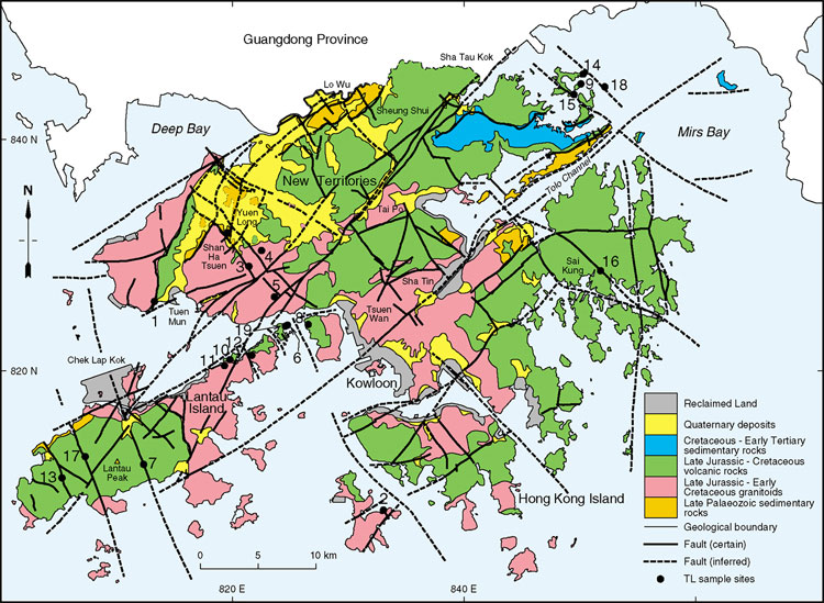
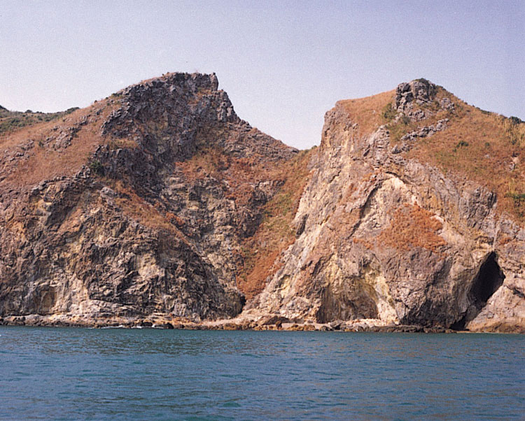
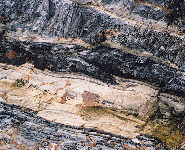
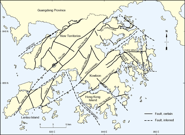
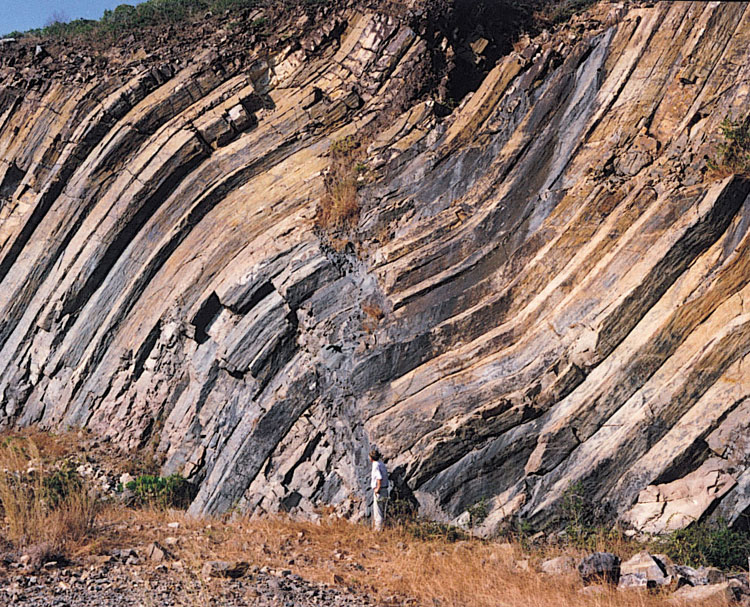
The framework of known and inferred faults in Hong Kong is shown in Figure 9.7. In most instances, faults are poorly exposed and they often underlie superficial deposits. The published 1:20 000-scale geological maps show faults only in areas of solid geology and do not show their concealed traces beneath areas of superficial deposits, although these can often be inferred with reasonable confidence. The faults are typically zones of deeper weathering penetration and enhanced erosion (Plate 9.1). Therefore, they usually form linear topographic depressions. These in turn are exploited by surface and shallow subsurface drainage, further enhancing processes of weathering and erosion along these zones and subsequent deposition of Quaternary superficial deposits (see Fyfe et al., 2000).
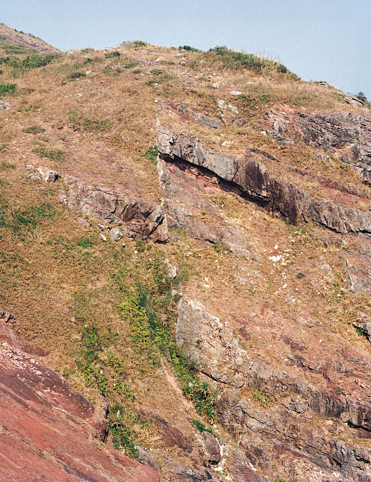
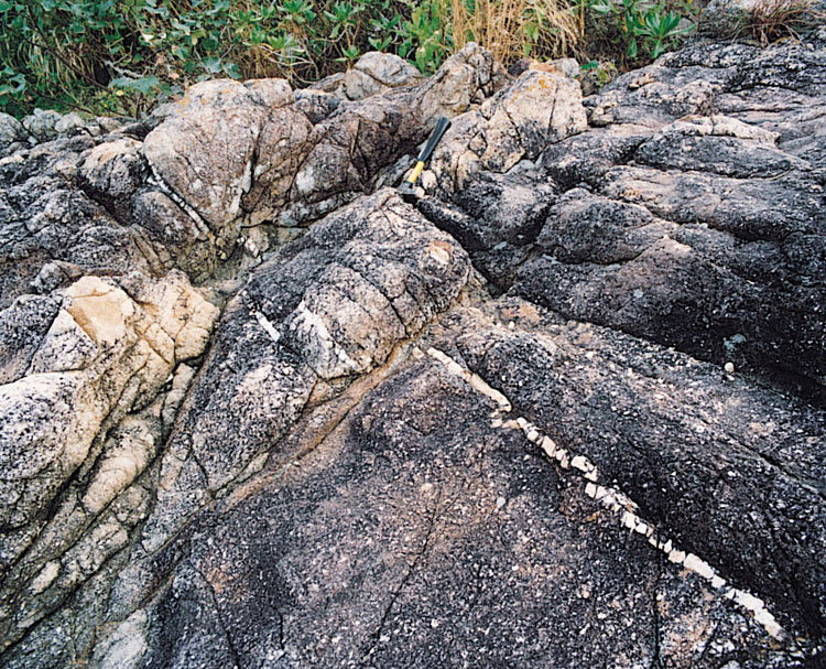
Minor faults with demonstrable displacements of up to a metre or two (Plate 9.2), are commonly observed in cut slopes and can often be traced for up to several metres or sometimes tens of metres. However, major faults inferred to extend for distances varying from hundreds of metres up to tens of kilometres, are less commonly exposed, other than in boreholes, tunnels and some very large cut slopes. Consequently, there are relatively few detailed descriptions of the major fault zones in Hong Kong, and their kinematic histories are generally poorly understood. Furthermore, their often complex structural evolution can prove very difficult to resolve even where exposure is good. This is especially the case where the fault has been activated under varying far-field stress orientations and structural regimes, and where magmatic and hydrothermal overprinting have been extensive.
Major faults are often subvertical or relatively steeply inclined (>70º, Plate 9.3). However, there are two significant exceptions: the San Tin Fault in the northwestern New Territories and the Tiu Tang Lung Fault in the northeastern New Territories. Both structures dip at moderate angles, the former towards the northwest and the latter to the north.
The main faults in Hong Kong strike northeast varying to northnortheast, and northwest- varying to north-northwest. There are also some easterly- and a few northerly-striking faults.
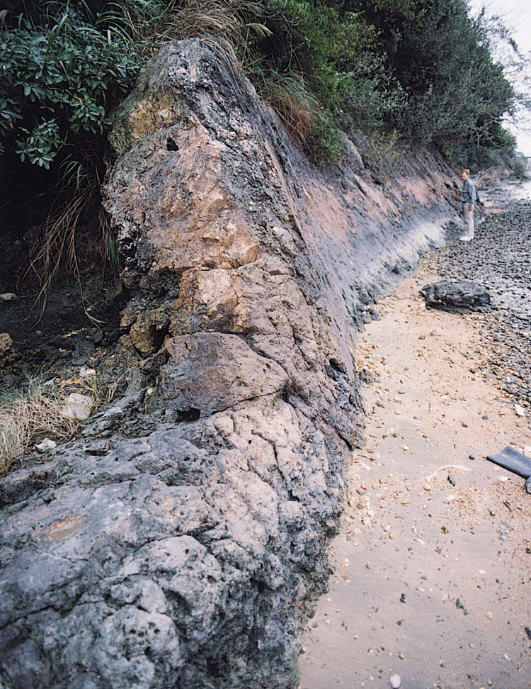
Northeast-striking faults are the most laterally persistent in Hong Kong. This orientation is consistent with that of the Lianhuashan Fault Zone as a whole, and of the Shenzhen and Haifeng faults that bound the zone in the vicinity of Hong Kong. Bennett (1984) inferred that the zone was dominated by strike-slip movement. The main faults in this set are the Deep Bay Fault, the Tuen Mun Fault, the Tai Lam Fault, the Sha Tau Kok Fault, the Tolo Channel Fault and the 'Jordan Valley fault' (Chapter 7). The Tolo Channel Fault (Plate 9.4) is inferred to extend for c.60 km and the Sha Tau Kok Fault for at least 55 km. The Shenzhen and Haifeng faults can be traced for hundreds of kilometres (BGMRGP, 1988). Major northeast-trending faults typically occur 6 to 12 km apart. They have been periodically active, probably since the Late Palaeozoic and some may be related to deep-seated basement structures of Proterozoic or Archaean age. They appear to have exerted a significant control on Jurassic to Cretaceous magmatism with individual faults being identifiable as conduits for magma and the loci of fissure-like volcanic centres (Campbell & Sewell, 1997) (Chapters 5, 6 & 7). Northeast-striking faults strongly influence the present topography.
Northwest- and northnorthwest-striking faults, though less laterally continuous than northeast-striking faults, form linear structures up to 20 km in length. They commonly appear to have been offset by northeast-trending faults but in a few other cases they are clearly the younger structures. Major northwest-trending faults are typically 4 to 12 km apart. They have been identified as controls of Jurassic to Cretaceous volcanism and plutonism (Campbell & Sewell, 1997) (Chapters 5, 6 & 7) but to a lesser extent than northeast- and east-striking faults. They have also controlled the development of small intermontane basins in which Quaternary alluvial and debris flow deposits have accumulated (Fyfe et al., 2000). Present river systems, estuaries, channels and sections of the coast are also commonly influenced by faults of this orientation (Ding & Lai, 1997). These include for example faults along the western margin of Mirs Bay (Fyfe et al., 2000).
East-striking faults are up to 12 km in length but are not regularly developed within Hong Kong. They are generally truncated by northwest-striking faults. The Chek Keng Fault is the best example of this set and was an important control of volcanism and magmatism (Chapters 5, 6 & 7)
North-striking faults are mainly restricted to the east of Hong Kong, along the western side of Mirs Bay (Chapter 8). In one instance, in the easternmost New Territories, a north-striking fault has been traced for 25 km.
Indicators of fault movement
The three main styles of deformation associated with faults and shear zones are brittle, brittle–ductile and ductile deformation (Ramsay, 1980). The development and behaviour of a fault reflects the overall structural regime which is influenced by a variety of factors such as the prevailing pressure–temperature regime, strain rate, and lithology. Faults may be initiated within one structural regime, but later become reactivated within a quite different regime. Hence, the evolution of an individual fault or shear zone may be highly complex. In order to understand the movement history of a fault, kinematic (movement) indicators are used and their relative ages determined using cross-cutting relationships.
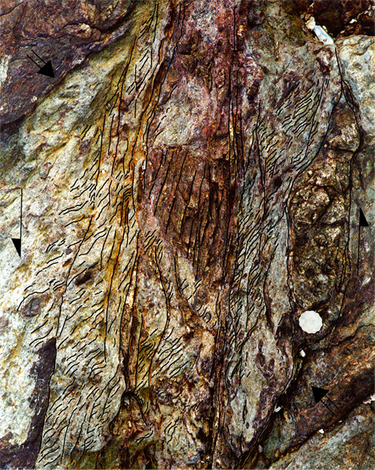
Kinematic indicators are either absolute or relative. Absolute markers indicate magnitude, direction and sense of movement of a fault on the basis of offset of a pre-existing feature in the rock. In Hong Kong, these include bedforms, mineral veins (Plate 9.5) and stratigraphic and intrusive contacts. Relative markers indicate only direction and, or, sense of movement only, on the basis of the orientation of structures generated as a result of the fault movement. Structures of this type that occur in Hong Kong include slickensides, S–C fabrics (Figure 9.8), en échelon veins (Plate 9.6), duplexes, transtensive and transpressive inflections, and asymmetric strain tails.
Characteristics of fault materials
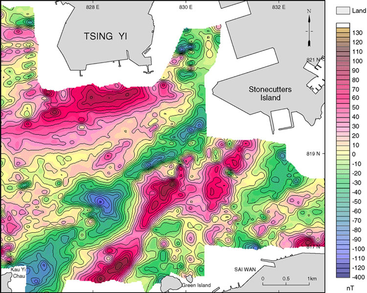
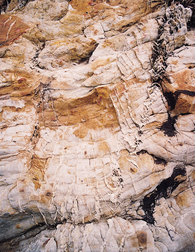
The compositions, geometries and structural histories of the faults in Hong Kong are variable and complex (Lai & Langford, 1996). Due to the lack of exposure in most fault zones, it has been impossible to characterise them comprehensively. Notable exceptions include complete sections through the northeast-trending Tolo Channel Fault near Sha Tin and the northnorthwest-trending 'Rambler Channel fault' between Tsing Yi and Stonecutters Island. These are described in detail below and are considered to be typical of many faults in Hong Kong.
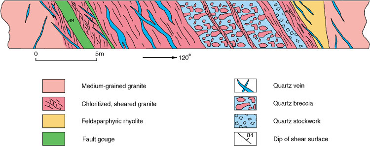
To date, the most complete section through the Tolo Channel Fault has been that exposed at the entrance to a water tunnel near Sha Tin. There, the fault zone is approximately 30 m wide and consists of a steeply dipping zone of quartz breccia, sheared granite and fault gouge. The shearing is associated with intense chloritization and kaolinitization of the host granite, and S–C fabrics indicate a component of lateral displacement.
The 'Rambler Channel fault' was recently exposed in a deep offshore tunnel between Tsing Yi and Stonecutters Island. There, the fault displaces medium-grained granite of the Sha Tin Pluton and truncates a feldsparphryic rhyolite dyke belonging to the Lantau Dyke Swarm. The fault zone, which is approximately 20 m wide and dips steeply to the east, displays evidence of several episodes of brittle, brittle–ductile, and ductile deformation. These styles of deformation are manifested by zones of quartz breccia and fault gouge, sheared granite with quartz lenses, and mylonitic granite with S–C fabrics respectively (Figure 9.9). The western margin of the fault zone is gradational over several metres, from an undeformed medium-grained granite with a few thin quartz veins to an intensely sheared and chloritized granite adjacent to a 1 m-thick fault gouge. S–C fabrics indicate that reverse and left-lateral displacements, or an oblique combination of the two, have occurred. The brittle style of deformation, mainly confined to the eastern part of the fault zone, consists of a thick stockwork of multiphase quartz veins within altered granite. The stockwork is cut by a few thin mylonitic shears. Close to the eastern margin of the fault zone, a 1.5 m-thick quartz breccia, consisting of angular fragments of white quartz set in a black cryptocrystalline quartz matrix, is flanked by well-defined layers of intensely sheared granite. Undeformed granite and feldsparphyric rhyolite, which are both cut by sets of thin quartz veins, form the hanging wall of the fault zone.
Fault history
Pre-Yanshanian faults
It is rarely possible to determine whether or not faults are pre-Yanshanian in age. As yet, no orientation or style of fault has been uniquely attributed to deformation prior to the Yanshanian. However, it is possible that faults occurring within the axial zones of asymmetric, close folds in the Devonian Bluff Head Formation and the Permian Tolo Channel Formation in the Tolo Channel region, are Late Permian or even post-Permian, but pre-Yanshanian in age. These faults are subvertical, with steep dips to both northwest and southeast, and they strike to the northnortheast, varying to the northeast and more locally to the north. It is also arguable that the genesis of the folds in the Palaeozoic rocks of this area was associated with pre-Yanshanian movement on the northeast-striking Tolo Channel Fault and that a dextral component of movement can be inferred on the fault at this time.
Yanshanian faults
Syndepositional faults associated with soft sediment deformation
Minor intraformational faults that are broadly syn-depositional, are commonly identified in the Jurassic and Cretaceous formations. This is especially so within the mainly epiclastic horizons that occur within the Late Jurassic to Early Cretaceous volcanic succession. The best example of this style of deformation is in the Lai Chi Chong Formation (Plate 9.7) on the south side of Tolo Channel. Here, a wide variety of faults are associated with soft sediment folding and dewatering of the well-bedded mudstone, siltstone, sandstone and tuff succession. Low-angle, northeast-dipping thrust-like faults are common in association with tight to recumbent folds. Conjugate extensional faults are also well developed, sometimes with related hydraulic breccias.
Faults associated with volcanism and plutonism
The spatial distribution and shape of Middle Jurassic to Early Cretaceous volcanic centres and related plutons was strongly controlled by extension across easterly, and eastnortheast-trending structures (see Chapters 5, 6 & 7). The main faults of these orientations that were active include in particular the Chek Keng Fault, the Tin Ha Shan Fault, the Tolo Channel Fault, and the easterly section of the 'Jordan Valley fault' (Chapter 7). The relative role of strike-slip movement on these structures may have varied during this time (164–140 Ma) from dextral to sinistral. Some northwest-trending faults may also have been active, such as the 'East Lamma Channel fault' and the fault that bounds the Ngo Mei Chau Formation on Crooked Island in the northeast New Territories.
Faults associated with basin development
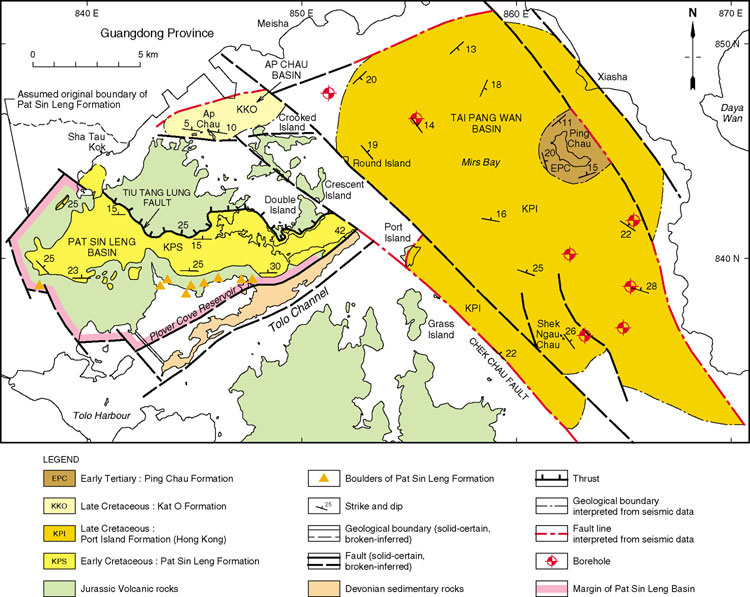
Three sedimentary basins are thought to have formed during the late Yanshanian orogeny and basin development possibly persisted into post-Yanshanian times. They are the Early Cretaceous Pat Sin Leng Basin, preserved mainly onshore in the northeastern New Territories, and the Late Cretaceous Tai Pang Wan and Ap Chau basins, both of which are preserved largely offshore in Mirs Bay (Figure 8.6). The Early Tertiary Ping Chau Formation overlies the Late Cretaceous sedimentary rocks of the Tai Pang Wan Basin without any marked stratigraphic break. These three basins are described more fully in Chapter 8.
The Pat Sin Leng Basin is bounded to the north by the northerly-dipping Tiu Tang Lung Fault (Figure 8.6; see below). Hence, the basin resembles a foreland basin. The northeast-trending Sha Tau Kok Fault on the western side of the basin may also have been an active strike-slip fault during basin formation (see below).
The northwest-trending Tai Pang Wan Basin, centred on Mirs Bay (Figure 8.6), is bounded to the southwest by the Chek Chau Fault, which is downthrown on its northeast side. The basin as a whole may therefore be transtensional rather than purely extensional.
The Ap Chau Basin, on the northern side of Crooked Harbour, is bounded by easterly trending faults. These are presumed to have been extensional faults at the time of basin development (Figure 8.6).
Thrust faults
Two major thrust faults have been identified, the San Tin Fault in the northwestern New Territories and the Tiu Tang Lung Fault (Figure 9.11) in the northeastern New Territories. Both structures dip at low to moderate angle, the former towards the northwest and the latter towards the north. Recent Ar–Ar age dating of whole rock specimens (GEO, unpublished data) suggest that their main phase of activity was between 60 and 90 Ma, during the Late Cretaceous.
Strike-slip faults
The Late Jurassic and Early Cretaceous volcanic and intrusive rocks, and older sedimentary rocks, are affected by sinistral strike-slip on major northeast- and eastnortheast-trending faults in Hong Kong. Evidence for these movements includes outcrop scale kinematic indicators, most notably brittle–ductile S–C fabrics, evidence of physical displacements of major intrusive contacts and volcanic centres, and brittle offsets of minor veins. However, the age of the movements has yet to be established with confidence. Recent Ar–Ar age dating of whole rock specimens from the Tolo Channel Fault and the 'Rambler Channel fault' (GEO, unpublished data) suggests that their main phase of activity was between 60 and 80 Ma, during the Late Cretaceous. There is also evidence of major strike-slip faulting of Cretaceous age having occurred in Guangdong Province and elsewhere in China (BGMRGP, 1988).
Absolute sinistral strike-slip displacements can be inferred on the basis of restoring individual volcanic centres and granite plutons that have been disassembled by the faults. Plausible reconstructions can be achieved by restoring sinistral offsets on individual faults by up to 3.2 kilometres. Similar continuity of Euler gravity anomalies (Figure 9.3) can be achieved using the same restorations, as can offset of magnetic anomalies (Figure 9.5a), especially offshore fault extensions to the southwest of Lantau Island. Also, zones of mineralization, such as the tin–tungsten mineralization that occurs between Tseung Kwan O and Needle Hill, fall into a northnorthwest linear alignment following restoration of sinistral strike-slip movements.
The most convincing example of absolute constraint on the scale of sinistral displacement along a fault system in Hong Kong is provided by the Sha Tau Kok Fault and related subparallel faults (e.g. the Tai Lam Fault, Plate 9.8), including its inferred extension to the southwest on Lantau Island, the Shek Pik Fault (Figure 2.7). The fault transects Lantau Island, where it appears to split into two main segments, one passing just to the south of Tung Chung and continuing to Shek Pik, the other crossing the eastern part of the island between Tin Tsui Tau and Pui O (Figure 2.7). Sinistral displacement is indicated by the following.
- Offset of a chain of granodiorite intrusions forming part of the Tai Po Granodiorite (164.6 ± 0.2 Ma) west of Tai Mo Shan suggesting sinistral offset of 3.2 km.
- Offset of the northern boundary of the Lantau Caldera in the vicinity of Tung Chung suggesting sinistral offset of c.3.1 km.
- Offset of the southern boundary of the Lantau Caldera and major granodiorite intrusions in the vicinity of Shek Pik by 3 to 3.5 km.
- Offset of feldsparphyric rhyolite dykes in east Lantau Island and of the linear outcrop of volcanic rocks on the northern side of Lantau Island, suggesting sinistral offset of c.1.2 km along a subparallel splay of the same fault.
- Offset of magnetic anomalies by c.3 km in the offshore area southwest of Lantau Island.
Despite the apparent offset of the westerly fault segment on Lantau Island by a northnorthwest-trending fault that passes just to the west of Tung Chung, there is consistency in the amount of sinistral offset of 3 to 3.5 km observed between Tai Mo Shan and Shek Pik.
Evidence of sinistral displacement on other major eastnortheast- and northeast-trending faults in Hong Kong includes the following (Figure 9.10)
- Sinistral offsets on individual faults of between 0.3 to 1.2 km at the contact of the Kowloon Granite and volcanic rocks of the Ap Lei Chau Formation in eastern Hong Kong Island.
- Possible sinistral offsets of granitic contacts and of the outcrop of Permian rocks on either side of the Tolo Channel Fault by between 1.2 and 2.2 km. This interpretation is supplemented by outcrop scale observations of S–C relationship and absolute offset of quartz veins indicating sinistral movement at Nai Chung Pier, Fung Wang Wat and elsewhere.
- Sinistral offset of a swarm of eastnortheast-striking quartzphyric rhyolite dykes north of Tuen Mun suggesting displacement of c.2 km.
A reconstruction of the main sinistral strike-slip faults in Hong Kong is shown in Figure 9.10. A further corollary of the sinistral strike-slip restoration of eastnortheast-striking faults is that some, but not all, conjugate northnorthwest-striking faults have a dextral offset. For example, the Sai Sha Road Fault (Figure 2.7) in the eastern New Territories, and a subparallel fault just to its south, appear to have dextral strike-slip offsets of c.700 m and 900 m respectively.
Basin development in Guangdong Province during the Early and Late Cretaceous, further suggests extension on S-shaped inflections in the main shear zones implying sinistral transtension.
Regional dynamic metamorphism
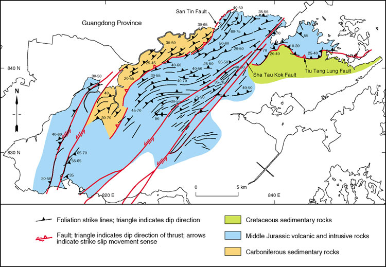
Regional dynamic metamorphism and deformation is characterised by the development of foliation. This varies from broad zones of schistosity to more discrete zones of protomylonite, mylonite and ultramylonite. Foliation is widely developed in zones in the northwest and northern New Territories. Typically it is inclined at moderate angle towards the northwest or north. The zones within which it occurs have been mapped out in some detail and are shown on the 1:20 000-scale geological maps of Hong Kong. The zones commonly have large-scale, open, Z-shaped outcrop patterns, shown best in the area between the San Tin Fault in the northwest and the Sha Tau Kok Fault in the central New Territories (Figure 9.11). The foliation clearly post-dates Middle Jurassic volcanism and possibly post-dates all Jurassic and Cretaceous volcanism. The foliation tends towards subparallelism with, and in the vicinities of, the moderately northwesterly-inclined San Tin Fault and the steeply inclined northeasterly-striking Sha Tau Kok Fault. This suggests that when the foliation formed, both the San Tin Fault and the Sha Tau Kok Fault were active. Recent Ar–Ar age dating of whole rock specimens (GEO, unpublished data) suggests that the main phase of activity of the San Tin fault was about 80 Ma, i.e. during the Late Cretaceous. Further Ar–Ar age dating of a weakly sheared coarse ash crystal tuff from the northwest New Territories has yielded an age of 102 ± 18 Ma. This also suggests, therefore, that the ages of formation of the foliation and the movement on the major faults were broadly similar.
Areas of foliated rocks have also been locally mapped on Lantau Island. These are commonly, but not exclusively, associated with known and inferred faults. The foliation is most readily observed in fine-grained lithologies, including minor sedimentary intercalations within the predominantly volcanic terrain. In some cases the foliation dips shallowly to moderately to the north or northwest. However, few systematic measurements of the foliation have been undertaken in this part of Hong Kong and its age of formation has not been established.
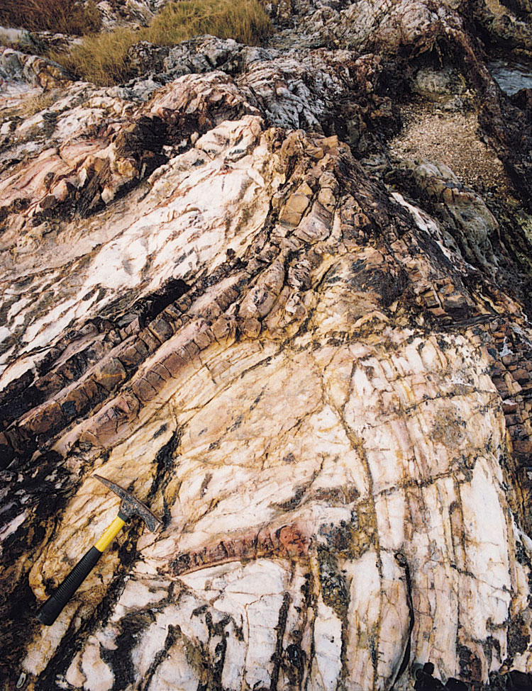
The metamorphism of limestone that led to the formation of marble in the New Territories may also have been associated with the same dynamic, and presumably thermal, metamorphic episode during which regional foliation formed and thrusting and strike-slip faulting possibly occurred. Alternatively, however, marble formation in general could have been associated with earlier magmatism and volcanism during the Jurassic and Early Cretaceous. Certainly, local occurrences of skarn mineralization (Chapter 10), such as at Ma On Shan, can be explained in terms of contact metamorphism caused by granitoid emplacement.
Post-Yanshanian faults
Recent Ar–Ar age dating of whole rock specimens (GEO, unpublished data) suggest that some of the major faults in Hong Kong have been active to within the last 3–4 Ma. These faults include the San Tin Fault, the Tiu Tang Lung Fault, the Tolo Channel Fault and the 'Rambler Channel fault'.
Ding & Lai, (1997), using thermoluminescence dating on fault gouges, have suggested that significant movements on northwesterly-striking faults in Hong Kong occurred as recently as 33 300 ± 2700 years BP (see 'Neotectonics' below).
Fold history
General
A wide variety of fold styles and scales of folding can be observed in Hong Kong. These can be interpreted both in terms of soft sediment deformation and tectonic deformation, variously associated with faulting, granitoid emplacement, volcanotectonic collapse and basin development.
Mesoscale folds, with wavelengths of metres to tens of metres, are most readily observable within the older sedimentary formations of Hong Kong, and especially the Devonian Bluff Head Formation, the Carboniferous Lok Ma Chau Formation and the Permian Tolo Harbour Formation. They are also seen locally within younger sedimentary and volcanic rocks of mainly Jurassic and Cretaceous ages. Larger scales of folding, with wavelengths of tens to hundreds of metres and more, and fold axial traces that extend for distances of hundreds of metres up to kilometres, have been mapped within the Devonian Bluff Head Formation, the Carboniferous Lok Ma Chau Formation, locally within Jurassic and Cretaceous volcanic formations. They have also been inferred within Cretaceous sedimentary formations.
Pre-Yanshanian folds
Evidence of pre-Yanshanian folding would only be expected within the limited outcrop of sedimentary rocks that predate the Mesozoic volcanism and plutonism. However, the age of deformation of these sedimentary rocks is uncertain. Certainly, they are commonly highly deformed and deformational styles and intensities are typically more extreme than those in younger rocks. However, deformation of multilayered sedimentary strata would be expected to differ in style and intensity from the younger, more massive volcanic and plutonic rocks even under the same far-field stress conditions.
Folds in Palaeozoic rocks
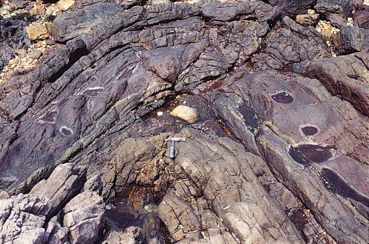
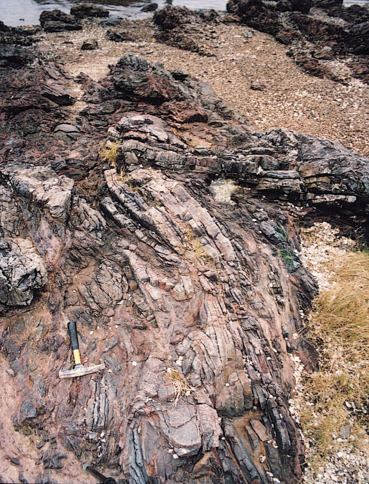
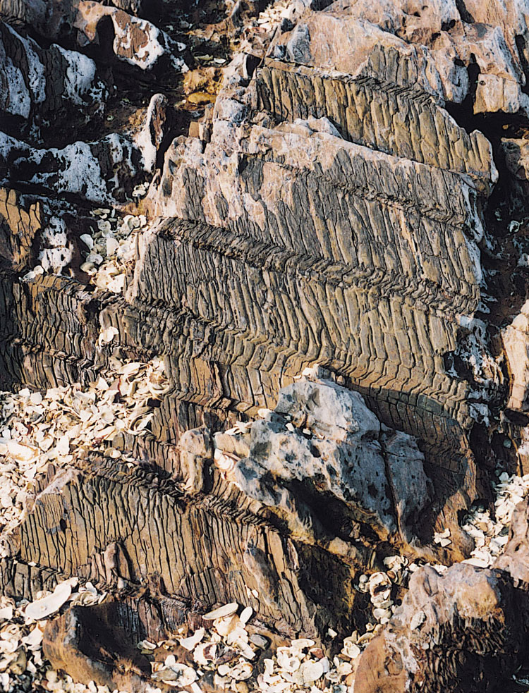
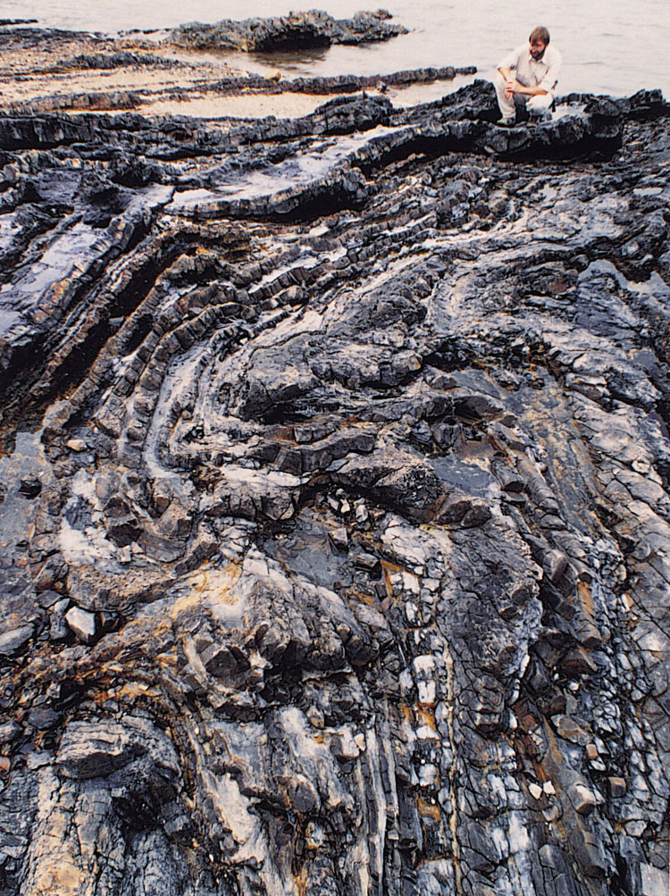
Excellent examples of mesoscale folds are exposed within the Devonian Bluff Head Formation near Bluff Head (Plate 9.9), and the Permian Tolo Harbour Formation (Plate 9.10 and Plate 9.11) on the southeast and northeast shores of Ma Shi Chau on the northwest side of Tolo Channel. The folds are typically close and asymmetric with axes trending northnortheast or northeast, although axial zones are often disrupted by faulting (Allen & Stephens, 1971; Addison, 1986). The folds also plunge steeply towards the northnortheast or northeast. Western limbs are vertical or overturned and strike subparallel to the fold axes whereas eastern limbs dip to the northeast at c.60o. Other folds in this area are thought to be drag folds related to sinistral faults (Addison, 1986). Open to close parasitic folds also occur along the northern side of Tolo Channel in general, on the south shore of Plover Cove Reservoir, and at Lo Fu Wat where minor synclines plunge to the southsouthwest and southwest and minor anticlines plunge to the northnortheast and northeast, or southwest. There is also evidence of a second phase of minor folding. This is manifested mainly in kink band development, which is well displayed in the Permian sedimentary rocks along the southeast shore of Ma Shi Chau (Plate 9.12), but the age of these structures is again uncertain. Allen & Stephens (1971) argued for more substantial minor refolding, with a fold set plunging towards the eastsoutheast. However, these folds may alternatively be conjugate structures developed broadly synchronously with the northnortheast-plunging folds.
On a larger scale, the Palaeozoic sedimentary rocks on either side of Tolo Channel have been interpreted (Allen & Stephens, 1971; Addison, 1986) as forming part of a regional anticline, the Tolo Channel Anticline. The faulted axial zone of this fold approximately coincides with Tolo Channel itself.
The Tuen Mun fault and fold belt on the northwest of Hong Kong, which strikes predominantly northeast but varies to north and eastnortheast, affects rocks of the Carboniferous Lok Ma Chau Formation. The folds comprise asymmetric, open to close anticlines. These are typically thrust-faulted along their northeast- and northnortheast-trending axial zones. Northwest limbs are broad and gentle whereas southeast limbs are narrow and steep, and may be cut out by faulting. Axial planes are therefore moderately inclined towards the northwest, which is subparallel to the dominant thrust orientation in this area (see above). Large scale folds of this type include (Langford et al., 1989): the Mai Po Anticline, a narrow, open to close fold which can be traced laterally for 11 km; the Yuen Long Anticline, entirely concealed beneath superficial deposits but proven from borehole evidence; the Sha Ha Tsuen Anticline; the Tin Shui Wai Anticline; and the Lam Tei Anticline. Intervening synclines are less readily identifiable in this area due to the effects of thrust faulting.
Yanshanian folds
Syn-depositional folds in Mesozoic strata
Small-scale to mesoscale disharmonic folds that are considered to be broadly syn-depositional, are common within epiclastic horizons within the Late Jurassic to Early Cretaceous volcanic succession. The best example of this style of deformation is present within the Lai Chi Chong Formation (Plate 5.23). Here, a wide variety of intraformational folds are related to soft sediment deformation and dewatering of the well-bedded mudstone, siltstone, sandstone and tuff succession. Two conjugate sets of folds appear to occur. One set comprises close to tight and recumbent Z-shaped folds, which plunge to the east and southeast. The other set comprises folds that are more open, S-shaped, and plunge to the east or eastnortheast. The former set is often associated with northeast-dipping thrust-like faults. In general, the asymmetry of the conjugate fold sets and the southerly directed sense of thrusting suggest oblique compression of the sedimentary sequence, possibly due to instability on a southerly-inclined palaeoslope.
Regional folds in Mesozoic rocks
Folds within the Jurassic and Cretaceous volcanic formations, including the interbedded sedimentary units, are typically open. Although the volcanic formations are often poorly stratified, the orientation of eutaxitic foliation, within several of the formations commonly provides a good general indication of the dip of the rocks. However, on a local scale, eutaxitic foliation often displays evidence of disturbance due to rheomorphism (secondary flow at the time of deposition) that can produce complex fold patterns that do not relate to the overall dip of the rocks.
In the northwest of Hong Kong, folds within Mesozoic rocks generally plunge to the southwest and are broad and gentle. They include the Yuen Sha Syncline which lies within the Tuen Mun Fault, adjacent to the Tsing Shan Granite. The fold has a northeast-trending axial plane trace and plunges both to northeast and southwest. The Shan Shek Wan Anticline is a narrow to close, northerly-trending fold adjacent to the Tsing Shan Granite.
On the western side of Hong Kong Island, fold axial plane traces predominantly trend northwest. They become more westnorthwest-trending towards the southwest of Hong Kong Island and are typically easterly-striking in the southern part of the island. These folds, which are gentle and open, have been identified largely on the basis of variations in the orientation of eutaxitic foliation. They appear to show a systematic variation in orientation with the strike of the contact of the Kowloon Granite. This suggests that the folds may be annular structures, formed as a result of the diapiric emplacement of the subcircular granite pluton.
Post-Yanshanian folds
Cretaceous sedimentary formations are gently folded at most. This folding can be related mainly to basin development and basin subsidence (Chapter 8). Locally, folding related to faulting and foliation/cleavage development is also evident.
Joints
Representative joint orientations are shown on the HKGS 1:20 000-scale geological maps of Hong Kong and these data are shown on contoured stereoplots in the accompanying memoirs. However, these comprise only a very small fraction of available joint data in Hong Kong, most of which have been acquired during site investigations. Further joint data are also contained in Geotechnical Area Study Reports (e.g. GCO, 1984) for selected parts of Hong Kong. Despite the wealth of available joint orientation data, the regional development of joints has received relatively little attention to date. The following four main modes of genesis of joints can be considered, however:
- Columnar jointing related to cooling and contraction of magmatic and pyroclastic bodies.
- Jointing associated with the deformational envelopes around diapirically emplaced plutons.
- Jointing associated with regional tectonic deformation, and particularly with the network of regional faults.
- Stress relief jointing formed as a result of weathering and erosion.
Columnar jointing occurs in many lavas, intrusive rocks and eutaxitic pyroclastic rocks in Hong Kong. The most spectacular examples are seen in the fine ash tuffs of the High Island Formation, exposed widely on the eastern side of Hong Kong (Plate 9.13). Individual columns can be traced vertically for tens of metres. Other examples are described in Chapter 5.
Possible examples of jointing associated with pluton emplacement are seen in the country rocks surrounding the Kowloon pluton. There, sheeting joints are locally developed subparallel to the moderately inclined contact of the pluton. Other examples are described in Chapter 6.
Jointing thought to be associated with regional deformation and faulting is extensively developed. At many localities, two to four sets of subvertical joints occur. These can be shown, at least locally, to be subparallel to the dominant orientations of faults in the vicinity. This suggests a common far-field stress control of formation.
Stress relief joints are common. They are variably planar to shallowly concave upwards, and are subhorizontal or moderately inclined. Many, but not all, are subparallel to the local natural terrain. They may be associated with zones of subparallel exfoliation up to tens of millimetres wide. These zones may extend laterally for metres and even tens of metres. Kaolin and manganiferous minerals commonly occur in these zones, especially near the weathering front (Fyfe et al., 2000). Groundwater flow is especially common along these zones.
Neotectonic fault activity in Hong Kong
Neotectonic refers to tectonic activity that has occurred during the final stages of the earth's history. In Hong Kong, this has generally been taken to be the Quaternary Period. Evidence for neotectonic activity and the timing of fault movements relies on the study of the onshore and offshore geology, including the superficial deposits (Fyfe et al., 2000), indirect dating techniques and an analysis of recent seismic activity.
The youngest rocks exposed in Hong Kong are Early Tertiary in age. These, together with the older rocks, all display evidence of deformational events that were most probably related to fault movements. However, there is no direct evidence of fault displacements in either the offshore or onshore Quaternary superficial deposits that overlie in situ material. In particular, no displacements have been identified from the many hundreds of kilometres of offshore seismic lines of Quaternary offshore alluvial and marine sequences, and no onshore colluvial wedges are considered to have formed adjacent to recently active fault scarps. Thus, it has been necessary to resort to thermoluminescence (TL), optically stimulated luminescence (OSL) and carbon isotopes (C14) to date any recent fault movements.
The thermoluminescence dating technique has been used in Hong Kong to determine the age of unconsolidated alluvial sediments that overlie faults in bedrock, thereby providing a minimum age for the fault displacement (Ding & Lai, 1997). At Shan Ha Tsuen, just to the south of Yuen Long, a major northwest-trending fault is overlain by a sequence of alluvial deposits and organic-rich muds (Langford et al., 1989). The oldest alluvial layer in the sequence has yielded an OSL age of 81 000 ± 14 000 years. This is consistent with the sequentially younger TL, OSL and C14 ages obtained from the overlying sequence (Duller & Wintle, 1996). The age can therefore be considered to be the minimum age for movement on the underlying fault.
In northeast Hong Kong, Pleistocene alluvial deposits occur within the wide Lam Tsuen Valley, whose development was largely controlled by a major northeast-trending fault (see Ding & Lai 1997; Fyfe et al. 2000). However, a few kilometres to the northwest of Tai Po, the Lam Tsuen River abruptly alters its course into a narrow southeast-trending valley in which Holocene alluvial sediments have been deposited (Lai & Langford, 1996). The youngest alluvial deposits in the Lam Tsuen Valley to the north of the southeast-trending valley have yielded a TL age of 84 700 ± 16 300 years BP. The overlying organic lacustrine muds have been dated by the C14 method at 23 950 ± 5300 years BP. This indicates that the river capture occurred between these two dates, during the Late Pleistocene. The cause of the river capture is not certain, but the small catchment of the southeast-trending valley suggests that river erosion would not be sufficient to cause the necessary northwest migration of the headwaters. Lai & Langford, 1996 and Ding & Lai, 1997 have proposed that the best explanation for this river capture is Late Pleistocene displacement along a southeast-trending fault. This resulted in the damming of the old river course and the opening up of the narrow southeast-trending valley.
The thermoluminescence technique has also been used for the dating of fault gouge (Ji & Gao, 1988; Ji et al., 1994; Singhvi et al., 1994). In Hong Kong, the northwest- and northeast-trending faults have yielded TL dates of between 278 700 ± 23 100 and 33 300 ± 2700 years BP, with possible maxima of fault activity at approximately 100 000, 190 000 and 270 000 years BP. There appears to be no systematic distinction in TL ages obtained from the northwest- and northeast-trending faults, which would suggest that the regional strain was accommodated on both fault sets. The youngest TL date that has been obtained, 33 300 ± 2700 years BP, may indicate a relatively recent period of fault movement.
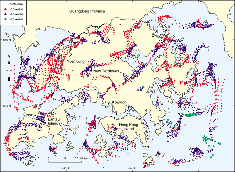
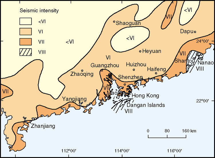
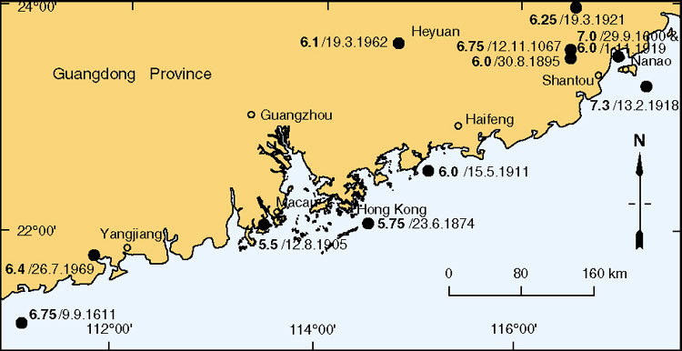
Recent fault movements in southeast China, as determined by the intensity of seismic activity, are generally concentrated along the coastal areas (Figure 9.12) and are due mainly to the interaction of the Eurasian and Philippine plates (Figure 2.2). Hong Kong is considered to lie in a region of moderate seismicity (State Seismological Bureau, 1990), although it has never experienced a major earthquake in recorded history. However, over the last 1000 years there have been more than 40 recorded earthquakes with magnitudes greater than 4.75 within a distance of 350 km of Hong Kong (Ding & Guo, 1989; GCO, 1991b, Pun & Ambraseys, 1992; Whittaker et al., 1992; Lee & Workman, 1996). Of these, eleven had magnitudes greater than 6.0 (Figure 9.13). The recorded earthquakes closest to Hong Kong have been: the Ms 6.0 event in Honghai Bay (85 km east of Hong Kong) on May 15, 1991; the Ms 5.5 event near Macau on August 12, 1905; and the Ms 5.75 event near the Dangan Islands on June 23, 1874. These, and other smaller events, are considered to be mainly related to displacements on either northeast-trending faults, including, for example, the fault close to the Dangan Islands (Figure 9.12), or northwest-trending faults, some of which define the margins of the Pearl River Tertiary sedimentary basin (Ding & Lai, 1997).
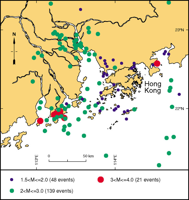
Microseismic activity in the Hong Kong region has been monitored more accurately by the Hong Kong Observatory since mid-1997, and a summary of the events recorded during 1998 is shown in Figure 9.14. Most of the events are located within the estuary of the Pearl River and, although relatively diffuse, possible northeast-trending linear arrays are apparent.