Introduction
Four major magmatic (volcanic–plutonic) episodes occurred in Hong Kong during the Middle and Late Jurassic, and Early Cretaceous (Chapters 5 & 6), a timespan of about 25 million years. Each episode records the emplacement of hundreds of cubic kilometres of rhyolitic magma, and possibly more, within the area of Hong Kong alone. However, individual episodes were separated by periods of a few million years during which time there appears to have been little or no magmatic activity.
There were marked changes with time in the bulk chemistry of the magmas, the locations and orientations of individual faults that acted as magmatic pathways, and the form and locations of the plutons, dykes and related volcanic centres. These changes are described in the following magmatic and volcanotectonic reconstructions and they are considered in relation to the evolution of the local and regional tectonic regimes.
Regional tectonic controls of magmatism
The dominant regional tectonic influence behind magmatism and volcanotectonism in southeastern China during Late Triassic to Cretaceous times has largely been ascribed to westerly subduction of the Kula–Pacific Plate beneath the Eurasian Plate (Huan et al., 1982; <span">Guo et al., 1983). This convergence was accompanied by movement on large-scale northeast-trending and subsidiary northwest-trending strike-slip faults, the development of broad open folds, and widespread magmatic activity along the continental margin (Yanshanian Orogeny, 190–70 Ma).
Magmatic evolution
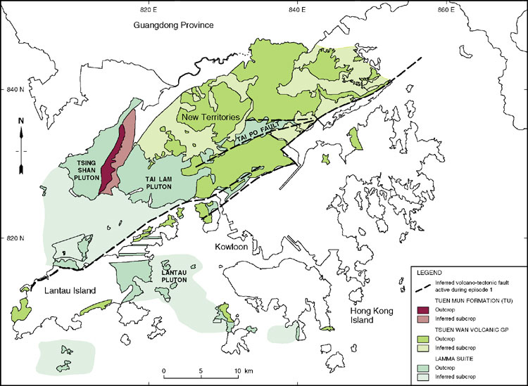
The first magmatic episode in Hong Kong comprised the Tsuen Wan Volcanic Group and 'I-type' Lamma Suite. Geochemical evidence (Sewell & Campbell, 1997) suggests that these magmas were derived from a mafic igneous-type ('I-type') source rock (protolith) with a late Archaean crustal signature (Darbyshire & Sewell, 1997).
The magmas may have been generated above an active subduction zone. Following this initial pulse of magmatism, a second thermal event, but still part of the first magmatic episode, involved remelting of these Lamma Suite 'I-type' granitoids. This produced the Lamma Suite 'A-type' granitoids. The heat responsible for this melting event may have been generated by an elevated mantle geotherm in response to crustal extension (Campbell & Sewell, 1997).
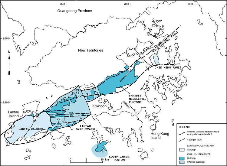
The second magmatic episode took place some 12 million years later, but was preceded by a minor thermal and magmatic event at 152 Ma (Davis et al., 1997). The second episode occurred in response to the onset of major crustal extension and addition in the Late Jurassic (148–146 Ma). It culminated in the production of 'A-type' magmas (e.g. Needle Hill Granite) that may also represent anhydrous melting of an earlier 'I-type' granitoid. These Late Jurassic magmas show mixed isotope signatures reflecting the involvement of both late Archaean and Mesoproterozoic crustal components in the source region (<span">Darbyshire & Sewell, 1997). The change in isotope signature was associated with the southeastward migration of magmatic activity across Hong Kong from an area presumed to be underlain by late Archaean crust to one underlain by dominantly Mesoproterozoic crust.
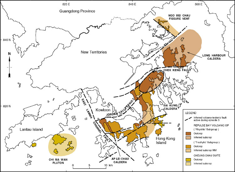
The third and fourth magmatic episodes, at 144 to 142 Ma and 140 Ma respectively, were associated with renewed pulses of tectonism, resulting in the development of major tensional structures. These enabled increasingly alkalic (K2O-rich) magmas to rise along fault zones of crustal dimensions. There is evidence that during these two younger episodes of magmatism, there were two distinctly different sources supplying magma to the surface (Sewell & Campbell, 1997). One source was characterised by magma with a low Zr/TiO2 ratio, similar to that of the calc-alkaline Middle Jurassic magmas (granitic/rhyolitic source). The other source generated magma with a relatively high Zr/TiO2 ratio, as is typical of the later alkalic (K2O-rich) magmas (trachytic/monzonitic source). Given the close proximity of these two contrasting magma-types, it is likely that they were derived from different depths in the crust. Of the two, the more alkalic magmas were probably sourced from deeper crustal levels where the mantle influence was stronger. However, the differing magmas appear also to reflect areas underlain by basement of contrasting age with Archaean to the northwest and Proterozoic to the southeast. As the focus of magmatism continued to migrate to the southeast, the late Archaean component in the magmas diminished and was replaced by a dominantly Mesoproterozoic source component. Magmatism also persisted along the main boundary zone between the two source terranes and ultimately provided the main conduit for the passage of strongly K2O-rich magmas to the surface (Sewell & Campbell, 1997). Later Cretaceous tectonic events were accompanied by sporadic intrusions of mafic to intermediate dykes, suggesting the growing influence of a mantle-derived component in the source region.
The magmatism and associated tectonism is consistent with a change in tectonic setting from one of crustal convergence to strong divergence. This divergence was transtensional to some extent, being accompanied to varying degrees by strike-slip faulting. The overall setting, therefore, seems to have evolved from essentially a continental volcanic arc environment, associated with westerly subduction, to a back-arc environment. Strong transtensional stresses operative in this back-arc environment controlled the loci of magmatism and ultimately the composition of eruptive magmas. The southeastward shift in the magmatic loci may represent an overall oceanward migration in the position of the subduction zone as more igneous material was accreted to the continental margin.
Fault controls of volcanism and plutonism
Individual faults
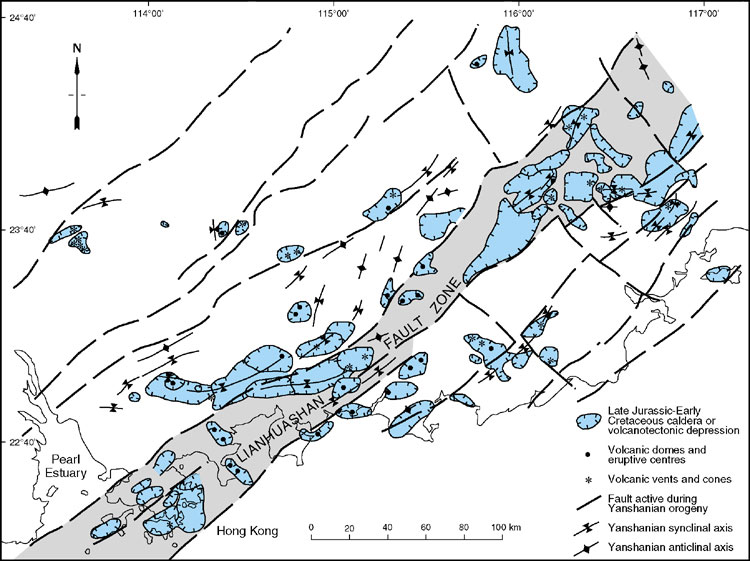
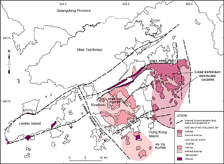
Mesozoic structure in Hong Kong was dominated by the mainly northeast-trending Lianhuashan Fault Zone (Figure 2.3), within which the main fault trends are variably northeast- to east-striking. Several faults are thought to have influenced the individual episodes of volcanism and intrusive magmatism (Figure 7.1, Figure 7.2, Figure 7.3 & Figure 7.4). These faults have been identified on the basis of the distribution of plutons, subvolcanic dykes and stocks, high viscosity lavas and sills, and calderas. The most important of these faults are described below.
As volcanism evolved, the locations of the main eruptive centres and their plutonic equivalents migrated from northwest to southeast, indicating that the focal point of principal extension also migrated. There is evidence in the changing orientations and characteristics of volcanic centres and their controlling structures with time, that during the Mesozoic volcanic period as a whole, changes occurred in the regional stress field. These tectonic transformations strongly influenced the nature, location and geochemistry of volcanism and are likely to have been ultimately controlled by the evolving plate tectonic configuration at the time.
Chek Keng Fault
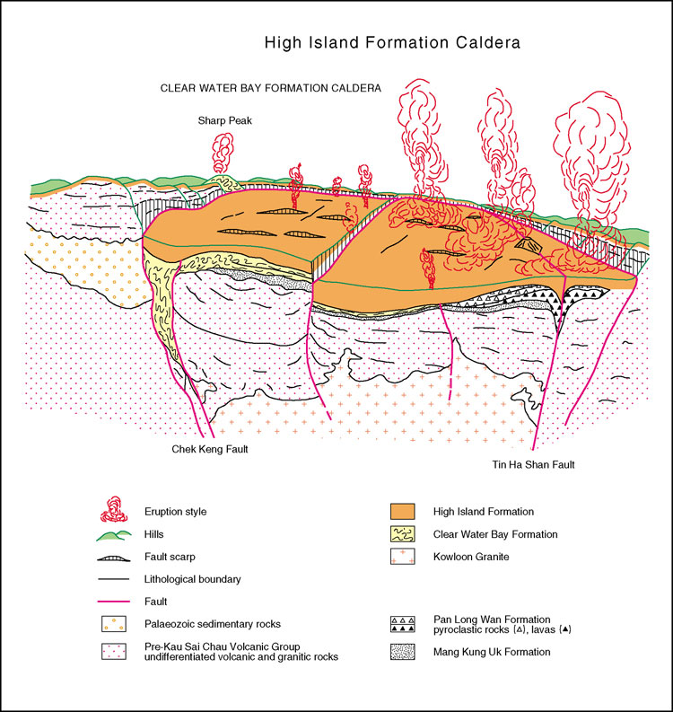
This east–west, varying to eastnortheast–westsouthwest-trending fault, includes features in a zone up to 1200 m wide that can be traced for 28 km. The fault was one of the most important and long-lived controls of volcanism in Hong Kong. For example, it appears to have formed the southern margin of the Long Harbour Caldera (Figure 7.3), the northwestern margin of the Sai Kung Caldera, and was the fissure from which the Clear Water Bay Formation rhyolite flows were erupted (Chapter 5). In addition, it is also the northwestern and southeastern limits of the Kowloon Granite and the Sha Tin Granite respectively, and appears to have controlled the emplacement of dykes of several ages and compositions, including quartzphyric rhyolite and monzonite (Chapter 6). The fault may also have been the source from which rhyolites were emplaced, and conglomeratic fans derived, within the Lai Chi Chong Formation and its underlying strata. Finally, the fault may have acted as a conduit during the eruption of the High Island Formation, and been one of the bounding structures during its associated volcanotectonic collapse (Figure 5.28).
Tin Ha Shan Fault
This broad zone of faulting, intrusion and extrusion (up to 1400 m wide) (Figure 7.4), varies in strike from east to eastnortheast and extends for more than 14 km. The fault passes through Clear Water Bay in the eastern New Territories and across the Chai Wan area on eastern Hong Kong Island.
The fault is interpreted as a persistent control of volcanism that acted as a conduit to the surface for magmas related to several formations. These include the block-rich pyroclastic facies and eutaxites (Silverstrand Member) of the Che Kwu Shan Formation and welded tuffs of the High Island Formation, both occurring in linear outcrops within the fault. Lavas in the Mang Kung Uk and Pan Long Wan formations can also be traced to sources along the Tin Ha Shan Fault. The fault also influenced emplacement of dykes of varying composition and grain size, including microgranite, quartzphyric rhyolite and monzogranite, and coincides with the southeastern limit of the Kowloon Granite.
Tolo Channel Fault
This comprises discrete faults within a zone up to 750 m wide, and can be traced in a northeasterly direction for at least 30 km through the central New Territories (Figure 7.1 & Figure 7.2). For much of its course, the fault lies offshore on the northern side of Tolo Channel where it appears to define the northwestern limit of the Long Harbour Caldera. Northeast of Ma On Shan, the fault comprises two main structures which may have formed the bounding margins of a graben during deposition of the Tolo Channel Formation. The northerly of the two faults is locally exposed along the northern coast of Tolo Channel. Southwest of Ma On Shan, one of the two faults extends to Lai Chi Kok where it has also been referred to as the Lai Chi Kok Fault (Lai & Langford, 1996). The other fault continues more westerly towards Tsuen Wan and broadly coincides with the northern boundary of the Sha Tin and Needle Hill plutons, and the northern limit of a swarm of feldsparphyric rhyolite dykes on Tsing Yi. There may have been a further westerly extension of the fault along the north coast of Lantau Island, beyond the inferred 'East Lamma Channel fault’ (see below). The more southerly of the two structures has less obvious influence on the distribution of magmatic rocks and may be an entirely post-volcanic feature.
'Jordan Valley fault'
A fault is inferred to underlie the northeast-trending Jordan Valley. Mylonite has been observed locally in outcrop along the trend of the fault but there is some doubt as to the lateral continuity of this structure. Hence the structure is referred to informally as the 'Jordan Valley fault'. The likely continuation of the 'fault' farther northeast runs along the southeast margin of the Sai Kung Caldera (Figure 7.3), and may also have formed the northwestern margin of the caldera that ponded the Ap Lei Chau Formation. The fault also coincides with the northern limit of the Silverstrand Member of the Che Kwu Shan Formation. Hence, it may have been active during the emplacement of the member, acting as a topographic barrier to its northward spread.
Faults north and south of Lantau Island
A pair of faults, trending eastnortheast–westsouthwest are tentatively inferred to have lain just offshore to the north and south, respectively, of Lantau Island. The interpretation of the fault to the north is complicated by the later development of the Sha Tau Kok Fault and for this reason is not formally named. However, this fault (Figure 7.2) may have been the northerly limit of the zone of major extension within which both the Lantau Caldera developed (147–146 Ma) and, at the same time, the Lantau Dyke Swarm was intruded. Subsequent intrusions of quartzphyric rhyolite, monzogranite and lamprophyric dykes also suggest further control of emplacement of magma by the same zone. The southerly of the two faults is thought to lie mainly along the southern coast of Lantau Island, but passing through Chi Ma Wan and possibly continuing through Hei Ling Chau, and to the south of Chau Kung To. The zone marks the approximate southerly limit of the Lantau Caldera and Lantau Dyke Swarm. Substantial monzogranite intrusions also lie along this trend. Both of the faults, to the north and south of Lantau Island, can be regarded loosely as westerly extensions of the Tolo Channel Fault.
'East Lamma Channel fault'
A fault is inferred to underlie the East Lamma Channel which trends northnorthwest–southsoutheast along the west side of Hong Kong Island (Figure 7.3 & Figure 7.4). The inferred structure is considered to influence the location of present-day channels between Ma Wan and Tsing Yi, and Lamma Island and Hong Kong Island. Furthermore, the fault has been suggested (Campbell & Sewell, 1997) as having been a volcanotectonic structure on the grounds that the Ap Lei Chau Formation and Kowloon Granite do not occur to its west. However, the presumed trace of the fault lies entirely offshore and the existence of this fault has yet to be demonstrated conclusively by borehole or other means. Hence, it is referred to informally as the 'East Lamma Channel fault'
Crustal extension
Emplacement of magma within the crust, and volcanism in general, are both facilitated by crustal extension (Cas & Wright, 1987 and references therein). The corollary of this is that volcanic rocks can be used to interpret the location and orientation of extensional zones within the crust.
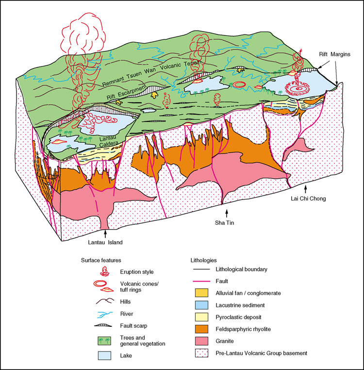
Considerable crustal extension occurred as a consequence of the Middle Jurassic to Early Cretaceous volcanism in Hong Kong. Virtually all of the central and southern parts of Hong Kong comprise magmatic and volcanic rocks of that age, although remnants of pre-existing crustal rocks may occur at greater depth. Specifically for example, on Lantau Island (Figure 5.27), approximately 75% of the width (northnorthwest–southsoutheast) of the eastern part of the island, in a zone 8 km wide, comprises easterly and eastnortheast-trending dykes of the Lantau Dyke Swarm. These were intruded during the second magmatic episode. Further westsouthwest, the generally eastnortheast-trending Lantau Caldera (Figure 5.27) also occurs within the zone, and developed at broadly the same time. Similarly, to the eastnortheast, the eastnortheast-trending Sha Tin and Needle Hill plutons, also part of the second magmatic episode, lie within the zone (Figure 5.27). Arguably, the Sai Kung and Long Harbour calderas of the third magmatic episode may also lie within an easterly extension of the same zone of extension.
Most of Lantau Island can therefore be regarded as silicic crust, several kilometres wide, and probably of substantial thickness too, created during the Late Jurassic (Campbell & Sewell, 1997). The granites, dykes and volcanic rocks, respectively, represent the deeper to shallower spectrum of levels of crustal development within a broadly extensional zone. The section of silicic crust exposed on Lantau Island is analogous in many respects to the layered structure of oceanic crust created at extensional mid-oceanic ridges: the granites on Tsing Yi and in Sha Tin are comparable to the lower part of layer 3 of oceanic crust (gabbroic magma chamber); the feldsparphyric dykes are equivalent to the sheeted dyke complex of upper layer 3; and the pyroclastic rocks occupy the same position as pillow lavas in layer 2. The late stage volcaniclastic and epiclastic deposits seen in the upper parts of the Lantau Volcanic Group can even be compared with layer 1 sediments.
Similar extension appears to have been associated with both the Repulse Bay and Kau Sai Chau volcanic groups. The extension was focussed respectively along the east- to eastnortheast-trending Tin Ha Shan Fault, and the east- to eastnortheast-trending Chek Keng Fault.
Rhyolitic volcanism and granitic magmatism, indicative of extension, ceased in Hong Kong after the eruption of the High Island Formation (Kau Sai Chau Volcanic Group) at c.140 Ma. However, Li (2000) has shown that 'A-type' granitic magmatism, and within-plate basaltic magmatism, continued throughout the Cretaceous in southeast China, to the northnortheast of Hong Kong. Further magmatic episodes occurred at 129–122 Ma, 109–101 Ma and 97–87 Ma. Li (op. cit.) has interpreted this magmatism as indicating a dominantly extensional environment in the region.
A notable feature of the later Cretaceous magmatic episodes is that they were largely concentrated in a fault-bounded zone to the west of the Haifeng Fault, and the Lianhuashan Fault Zone as a whole. Hence, the trend that has been identified in Hong Kong of volcanism and magmatism migrating southeasterly with time, appears to have been extended on a regional scale into the Late Cretaceous.
Crustal transtension
Selective extension of the crust can be controlled by large-scale strike-slip movements, with transtension generated at dilational jogs, or bends along the fault. Thus, for a dextral fault, a Z-shaped bend would be potentially transtensional whereas an S-shaped bend would be transpressive, and vice versa for a sinistral fault. Z-shaped inflection patterns are typical of the Tai Mo Shan area, and these appear to have controlled the locations of granodiorite intrusions related to the first magmatic episode (Middle Jurassic). This suggests the likelihood of a dextral shear component on the main eastnortheast-trending faults at the time of Tsuen Wan Volcanic Group volcanism.
The best example in Hong Kong of obliquity of the orientation of extension relative to major bounding faults is that shown by the Lantau Dyke Swarm associated with the second magmatic episode (Figure 5.27). Individual dykes within the swarm are commonly easterly-trending whereas the zone as a whole trends mainly eastnortheast. This sense of obliquity can be interpreted in terms of a pure shear model, as indicating a dextral strike-slip component of movement along the bounding margins of the zone, whereas essentially north–south extension occurred within the zone.