Introduction
Mesozoic sedimentary rocks that were laid down before the main Jurassic–Cretaceous volcanic episode (see Chapter 5) constitute less than 2% of the onshore area of Hong Kong. They comprise small outcrops of Early Jurassic sedimentary rocks in the western and northeastern New Territories and Middle Jurassic rocks in the western part of Lantau Island, in the Chinese University, Sham Chung, and Three Fathoms Cove (Figure 4.1). Despite their small areal extent, these rocks provide valuable information on the palaeoenvironmental setting immediately before the onset of widespread Jurassic to Cretaceous volcanic–plutonic activity.
Classification
The Mesozoic pre-volcanic sedimentary rocks in Hong Kong have been classified both in terms of chronostratigraphy and lithostratigraphy. The chrono-stratigraphy (i.e. Early, Middle and Late Jurassic) has been determined largely from the generally sparse macrofossil content of the rocks. However, the rocks have been mapped and interpreted by the Hong Kong Geological Survey (at 1:20 000 and 1:5 000 scales) mainly in terms of their lithostratigraphy (groups, formations and members). This has been largely based on grain size, bedform and facies characteristics (see Chapter 3 for details of the general classification of sedimentary rocks).
Early Jurassic
Regional Setting
Following the Triassic Indosinian Orogeny, sedimentation in southeastern China during the Early Jurassic was dominated by a marine transgressive sequence. Large areas of Guangdong were progressively flooded by the sea. Throughout the province this is recorded by the marine Jinji Formation. According to the palaeogeographic reconstructions of Wang (1985), northeast-oriented syndepositional faults were active during the Early Jurassic and these controlled the formation of epicontinental marine basins.
Distribution
Early Jurassic rocks in Hong Kong are confined to small exposures on both sides of Tolo Channel and to the south of Yuen Long (Figure 4.1), around the foothills of Tai Tong.
In the vicinity of Tolo Channel, the Early Jurassic rocks occur at four principal localities: Fung Wong Wat and adjacent sections of the coastline to the east-northeast and west-southwest, Sham Chung, Ma Shi Chau, and Nai Chung. These rocks are mainly exposed on shore platforms and they are not easily traced away from the coast. However, they have been reported at three inland localities near Nai Chung on the south side of Tolo Channel: Ma On Shan water reservoir, Cheung Muk Tau, and Tseung Kwan Le (Sewell, 1996). On the northern side of Tolo Channel, the exposures are bounded by a fault that strikes east-northeast, virtually along the coastline.
In the vicinity of Tolo Channel, the Early Jurassic rocks occur at four principal localities: Fung Wong Wat and adjacent sections of the coastline to the east-northeast and west-southwest, Sham Chung Ma Shi Chau, and Nai Chung. These rocks are mainly exposed on shore platforms and they are not easily traced away from the coast. However, they have been reported at three inland localities near Nai Chung on the south side of Tolo Channel: Ma On Shan water reservoir, Cheung Muk Tau, and Tseung Kwan Lei (Sewell, 1996). On the northern side of Tolo Channel, the exposures are bounded by a fault that strikes east-northeast, virtually along the coastline.
A substantial subcrop of Early Jurassic rocks, trending east-northeast, is interpreted to lie beneath Tolo Channel. This is masked by Quaternary superficial deposits.
Stratigraphy
Rocks of Early Jurassic age were first reported by Heanley (1924) following the discovery of an ammonite fossil (Hongkongites hongkongensis) in black shale on the north shore of Tolo Channel. These rocks were subsequently defined as the Tolo Channel Formation by Brock and Schofield (1926). They remained the only rocks in Hong Kong with a known age for nearly half a century. Williams (1943) included a further sequence of volcaniclastic siltstones and sandstones on the south side of Tolo Channel within the Tolo Channel Formation. However, these have since yielded Early Cretaceous fossils and are now assigned to the Lai Chi Chong Formation (Strange et al., 1990). Ruxton (1960) abandoned the term Tolo Channel Formation in favour of the Tolo Harbour Formation and Bluff Head Formation, but Allen and Stephens (1971) reintroduced it after recognizing the presence of three distinct formations. There is now considerable fossil evidence to support the identification of Early Jurassic rock sequences alongside Tolo Channel (Lai, 1989; Lee et al., 1990a).
Rocks previously assigned to the Carboniferous Lok Ma Chau Formation south of Yuen Long (Langford et al., 1989) have since been reassigned to the Tolo Channel Formation. This followed the discovery of an Early Jurassic ammonite (Yuen, 1989).
Depositional environments
A detailed sedimentological study of the Tolo Channel Formation has not yet been undertaken. However, based on a brief examination of the sequence at Ma Shi Chau, Jones (1995) identified the presence of low-angle, wavy cross lamination with rare, rounded and flattened mudstone clasts. The fauna confirms the succession was deposited under marine conditions. The interbedded lenses of sand are thought to represent sporadic influxes of sand which were probably reworked by wave action during a period of shallowing of the depositional basin. Most of the mudstones and siltstones are thought to have been deposited from suspension below wave base (i.e. > c.20 m water depth) as they do not contain wave ripples.
A shallow marine, sublittoral environment of deposition is inferred for the Tolo Channel Formation. Low energy conditions are indicated by the predominance of mudstone and siltstone. A gradual deepening of the basin is suggested by the steady increase in the proportion of mudstone higher in the succession. This is consistent with the overall trend of marine transgression during the Early Jurassic (Wang, 1985).
Palaeontology and correlation
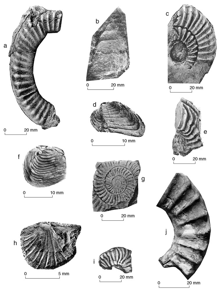
Since the discovery of the first ammonite fossil by Heanley (1924), sparse, but diverse assemblages of fossils have been recovered from the Tolo Channel Formation. These include several species of ammonites and bivalves, as well as gastropods, ostracods, scaphopods, brachiopods and crinoids (Lee et al., 1990a; Lai et al., 1996) (Plate 4.2). These fossil assemblages are similar to those reported from the Early Jurassic Jinji Formation of Central Guangdong Province (Wang & Smith, 1986), especially the sequence at Jinji (Atherton et al., 1990). Comprehensive descriptions of the Early Jurassic fauna are contained in Atherton et al. (1990) and Lee et al. (1990a).
Middle Jurassic
Regional setting
The Middle Jurassic of southeastern China is characterised largely by terrestrial sedimentation during which the transgressive sequence that had dominated the Early Jurassic, gave way to a regressive sequence, coupled with the onset of Yanshanian magmatism. Large areas of Guangdong Province became emergent and the sedimentary succession contains an increasing proportion of andesitic and rhyolitic pyroclastic material. According to palaeogeographic reconstructions for the Middle Jurassic by Wang (1985), a northeast-oriented fault-controlled intermontane basin existed to the northeast of Hong Kong. This hosted several andesite and rhyolite volcanoes.
Distribution
Middle Jurassic sedimentary rocks crop out in the western part of Lantau Island along its northern coast from Tai O to Sham Wat Wan, and in the Chinese University, Sham Chung, and Three Fathoms Cove.
Stratigraphy
Middle Jurassic sedimentary rocks have only recently been confirmed in Hong Kong following the discovery of Middle Jurassic plant fossils (Ng et al., 1997). Initially, these sedimentary rocks had been considered to belong to the "Older Sedimentaries" and were correlated with rocks now assigned to the Bluff Head Formation (Brock & Schofield, 1926; Williams, 1943; Ruxton, 1960). Allen and Stephens (1971) later reinterpreted the upper contact of the succession on Lantau Island as being conformable with the overlying volcanic rocks. As a result, they included these rocks within a new formation, the Tai O Formation, which they interpreted as Jurassic in age. Subsequently, Langford et al. (1995) abandoned this term, favouring instead correlation with the Carboniferous Lok Ma Chau Formation, exposed nearby on The Brothers islands. Despite this, however, they noted that a rhyolite lava interbedded with the upper part of the sedimentary succession at San Chau could imply that part of the succession was indeed Jurassic in age.
The term Tai O Formation is reintroduced here to include all sedimentary rocks exposed between western Tai O and Sham Wat Wan. Unlike the original definition of the formation proposed by Allen and Stephens (1971), rocks on The Brothers islands and those between Sham Wat Wan and San Shek Wan are excluded as they have demonstrable metamorphic overprint (e.g. graphite seams and andalusite crystals). The upper contact of the formation with the overlying volcanic rocks of the Tsuen Wan Volcanic Group, which are tentatively assigned to the Shing Mun Formation, is considered to be conformable. Based on stratigraphical assessments, correlation, and heavy mineral analysis, sedimentary rocks cropping out at the Chinese University, Sham Chung, and Three Fathoms Cove are unlikely to belong to the Permian Tolo Harbour Formation as previously reported by Addison (1986) and Strange et al., 1990. These rocks are more appropriately assigned to the Middle Jurrasic Tai O Formation.
Depositional environments
Jones (1996) has interpreted the Tai O Formation as indicative of deposition on an alluvial plain, crossed by small- to moderately-sized, bedload-depositing rivers.
The thick sandbodies are interpreted to represent the deposits of fluvial channels. Erosive bases are indicative of channel incisions whereas the coarse pebbly bases to many units are interpreted as lag deposits. The angular quartz granules in many of these sandbodies are similar in form to the quartz observed within tuffaceous sandstones and coarse ash tuffs elsewhere (e.g. Lai Chi Chong ). This suggests that a volcanic source lay nearby.
Periodic overbank flood events, in which water and sediment in suspension overtopped the channel banks, led to deposition of finer material (sandy silts) between the major river channels. Locally, small lakes were filled by prograding deltas fed by sediment from rivers.
Palaeontology and correlation
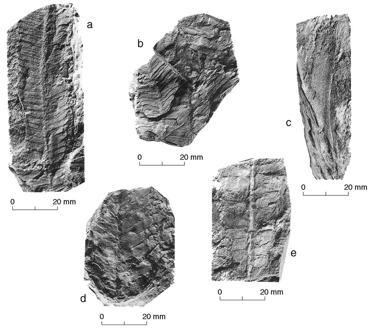
Recent fossil discoveries from the Tai O Formation (Ng et al., 1997) have included several late Early to early Middle Jurassic plants including Ptilophyllum contiguum, Otozamites hsiangchiensis, Tyrmia cf. nathortsti (Schenk), and Eretmophyllum sp. (Plate 4.4). These discoveries have led to tentative correlation of the Tai O Formation with the Qiaoyuan Formation in Guangdong Province.