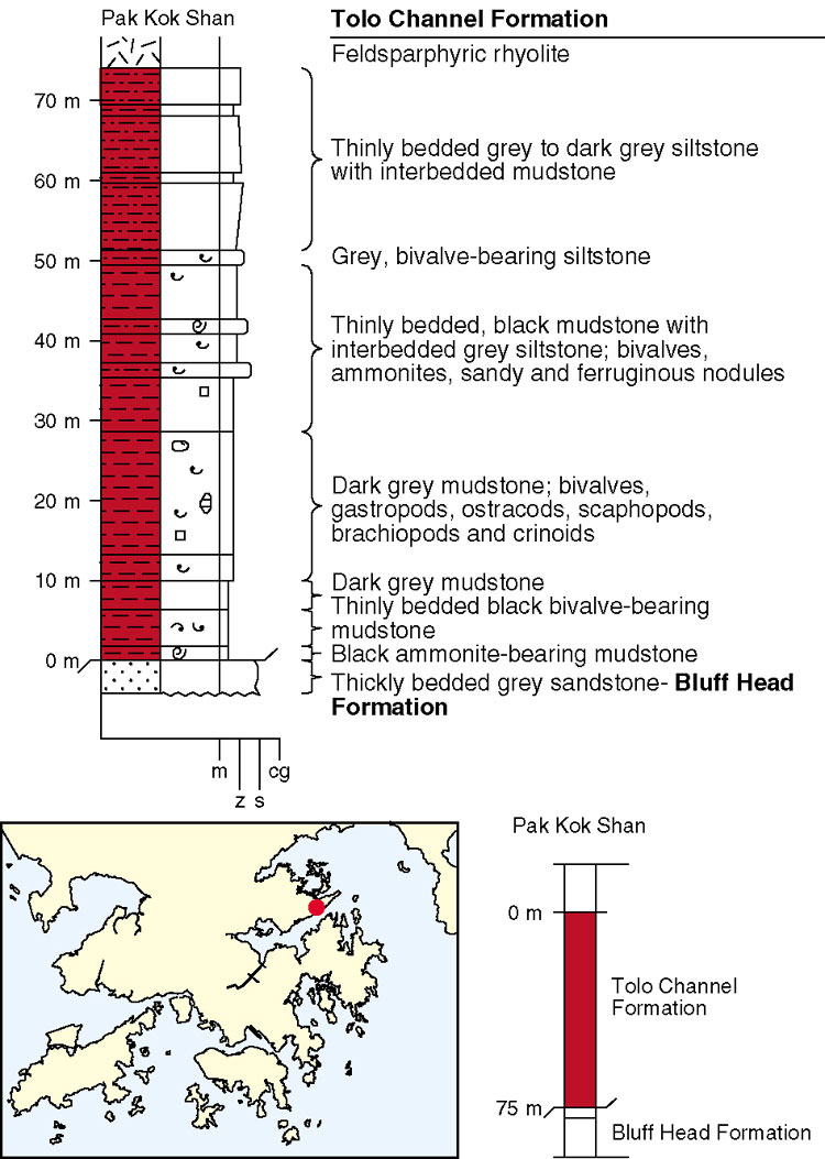
The Tolo Channel Formation dominantly consists of grey to greyish white, laminated siltstones with rare sandy lenses alternating with thinly-bedded fossiliferous black mudstone containing pyritous nodules. At the type locality, 1 km northeast of Fung Wong Wat, the strata dip moderately (c. 60o) to the northwest although fossil evidence indicates they are overturned. The formation has an exposed thickness of 75 m and is faulted at its base against the Bluff Head Formation. The top of the formation is not exposed. A composite type section from the north side of Tolo Channel, where the formation was first recognized, is shown in Figure 4.2.
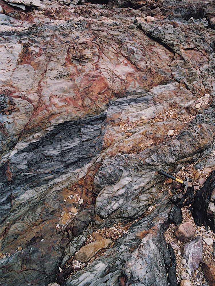
At Nai Chung, the Tolo Channel Formation strata are highly contorted and comprise highly cleaved, coarsely laminated siltstone alternating with finely laminated fossiliferous mudstone (Plate 4.1). At Ma Shi Chau, the strata consist of pinkish brown weathered, laminated micaceous siltstone and dip steeply to the west. They have yielded an ammonite fossil indicating a Jurassic age (Lam, 1973).
Details
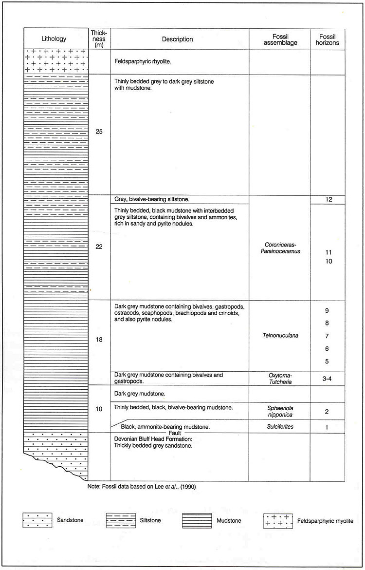
South Coast of Pak Kok Shan. The Tolo Channel Formation crops out in the intertidal zone of a headland on the south coast of Pak Kok Shan (850750 839160 Jc-1). The formation is 75 m thick and consists of thinly bedded black mudstone with grey to dark grey siltstone containing pyritous nodules. The strata dip northwest at 60o but fossil evidence indicates that they are overturned. Biostratigraphical sequences are shown in Figure 4.A1 and Table 4.A1. A quartzphyric rhyolite dyke, trending northeast, intrudes the succession parallel to the coast. On the south side of the dyke, black mudstones with crushed and silicified sandstone are exposed over a width of 5 m and they extend offshore.
Fung Wong Wat -Wong Wan Tsai. The formation is exposed on the marine platform, at the base of the adjoining hill, and in the intertidal zone. The outcrop is 30 to 120 m wide between Fung Wong Wat (849900 838500 Jc-2) and Wong Wan Tsai (848500 837700 Jc-3). The sediments comprise sandstone, which is locally pebbly with angular mudclasts, overlying black fossiliferous mudstone, which contains abundant pyritous nodules, with siltstone and sandstone. The strata dip at 20o. A quartzphyric rhyolite dyke intrudes the sedimentary rock near the low tide mark. On the adjoining hillside, bedding dips steeply and is contorted along the faulted contact with the Bluff Head Formation. More sandstones occur further southwest along the coast.
Lo Wu Wat. South of To Tau Tsui (846330 836550 Jc-4), the Tolo Channel Formation is exposed at low tide in a narrow outcrop, only 10 m wide, on the foreshore along the north coast of Chek Mun Hoi Hap (Tolo Channel). The thinly bedded siltstone with sandstone is dark grey when fresh, but is yellowish to reddish brown where it is weathered.
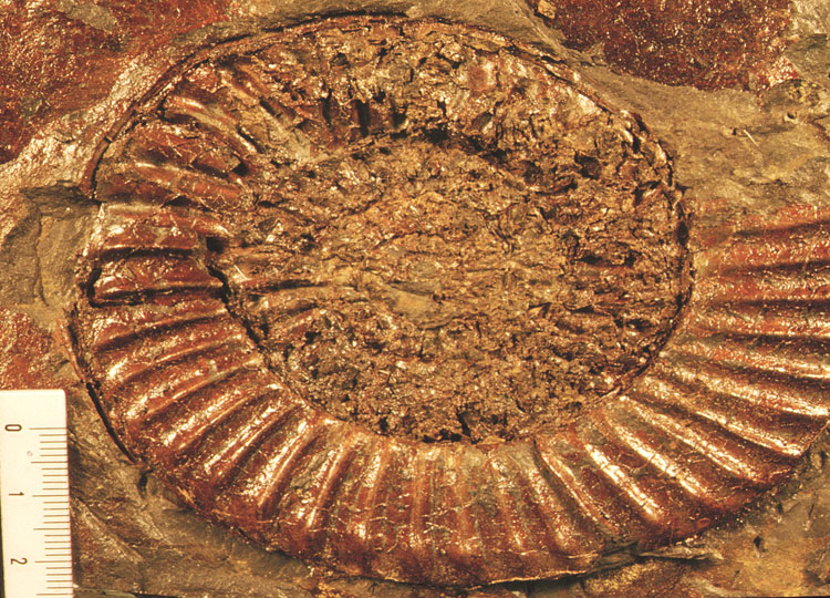
Ma Shi Chau. The Tolo Channel Formation is exposed on the foreshore at the southern tip of Ma Shi Chau (841080 834510 Jc-5), where it consists of pinkish-brown weathered, laminated, micaceous siltstones, dipping steeply to the west. About 150 m of strata are estimated, but the contact with the Permian strata to the southeast (841200 834450 Jc-6) is faulted. The strata are unconformably overlain to the northwest (841050 834530 Jc-7) by sedimentary breccia that forms the base of the Tsuen Wan Volcanic Group. The outcrop has yielded an ammonite fossil (Lam, 1973) indicating a Jurassic age. Apart from their steep dip, these strata are generally only weakly deformed, in marked contrast to the strata of the adjoining crop of Tolo Harbour Formation.
Nai Chung. At the jetty at Nai Chung (844220 832800 Jc-8) highly contorted, dark and pale grey siltstones and mudstones appear to underlie heterolithic conglomerates which crop out on the ridge immediately to the west. The siltstones and mudstones are reported to contain fossils of Jurassic age (C. M. Lee and P. S. Nau, oral communication).
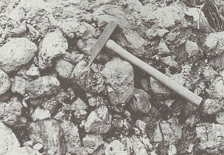
Sham Chung Kok. At the base of the formation, at Sham Chung Kok (846730 833740 Jc-9), a conglomerate about 20 m in thickness is overlain by 4 m of siltstone and a 6 m thick sandstone layer, all dipping northeast at about 45o (Plate 4.A1). The conglomerate is pale grey, bleached white in part and consists of rounded pebbles of quartzitic sandstone, vein quartz, pale grey chert and dark grey chert. The base of the conglomerate can be seen on the northern side of Sham Chung Kok (846620 833930 Jc-10) where it lies unconformably on strata presumed to belong to the Tai O Formation. Higher in the Tolo Channel Formation the rocks are mainly dark grey silty mudstones which have been sheared and indurated in places (846860 833850 Jc-11). They have yielded fossil plants and ammonites at several localities (846800 834100 Jc-12)(Plate 4.A2).
Tai Tong. The discovery by Yuen (1989) of an ammonite (Arietites sp) in sandstone at an outcrop south of Yuen Long (821120 830350 Jc-13) showed that this area contains Lower Jurassic strata. The sandstone mapped near Tai Tong, 2 km south of Yuen Long, is now therefore clasified as belonging to the Tolo Channel Formation.
To the south of Yuen Long, around Tai Tong, there are several isolated exposures of siltstone and fine sandstone. Near a small reservoir (820000 829200 Jc-14) are exposures of grey quartzite, metasandstone and metasiltstone, either massive or foliated. To the north the outcrop can be clearly defined as a roof capping to the underlying fine grained granite.
Near Sung Shan San Tsuen (822300 831700 Jc-15) an inlier of metasiltstone is faulted against tuffs of the Shing Mun Formation to the southwest, while to the northeast the metasiltstone appears to lie unconformably beneath a breccia which contains abundant clasts of the metasiltstone, and grades upwards into the overlying tuffs. Metasiltstone and siltstone is also exposed southeast of Tai Tong (821100 830500 Jc-16).