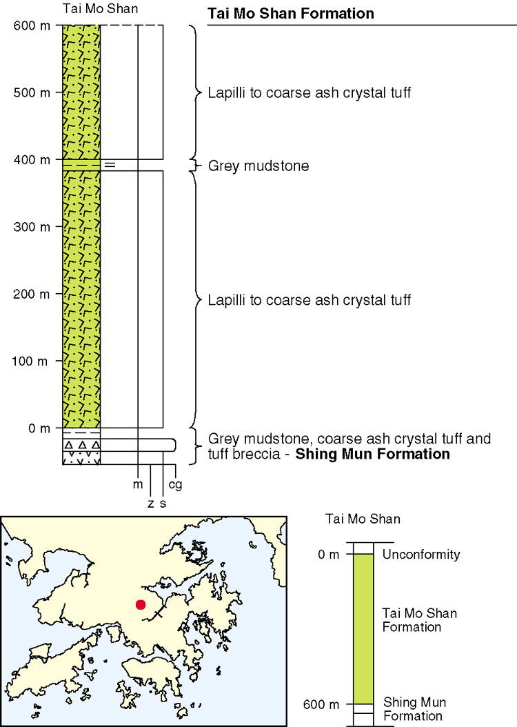
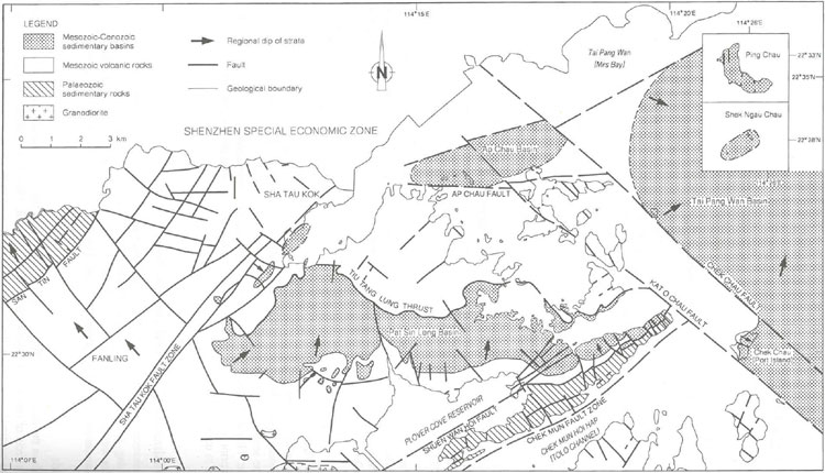
Previously, the Tai Mo Shan Formation (Table 5.4) was mapped over a wide area of Hong Kong, including much of the New Territories, and large outcrops in the Sai Kung and western districts. However, on the basis of detailed petrographic and geochemical study, supported by high precision isotopic dating, the outcrops in the Sai Kung and western districts have now been assigned to two younger formations: the Long Harbour Formation in the eastern New Territories, and the Mount Davis Formation on western Hong Kong Island. The bulk of the Tai Mo Shan Formation is now restricted to outcrops north and northwest of the Sha Tin Valley (Figure 5.7), including the high ground around Tai Mo Shan itself. The formation is thought to rest conformably on the Shing Mun Formation. Locally, on the western side of Tai Mo Shan, there is an impersistent eutaxite layer at this contact. At the type locality of Tai Mo Shan, the formation is at least 600 m thick (Figure 5.11), despite the absence of the top of the formation due to erosion. U–Pb dating of zircon crystals has yielded an age of <164.6 ± 0.7 Ma for the formation (Davis et al., 1997).
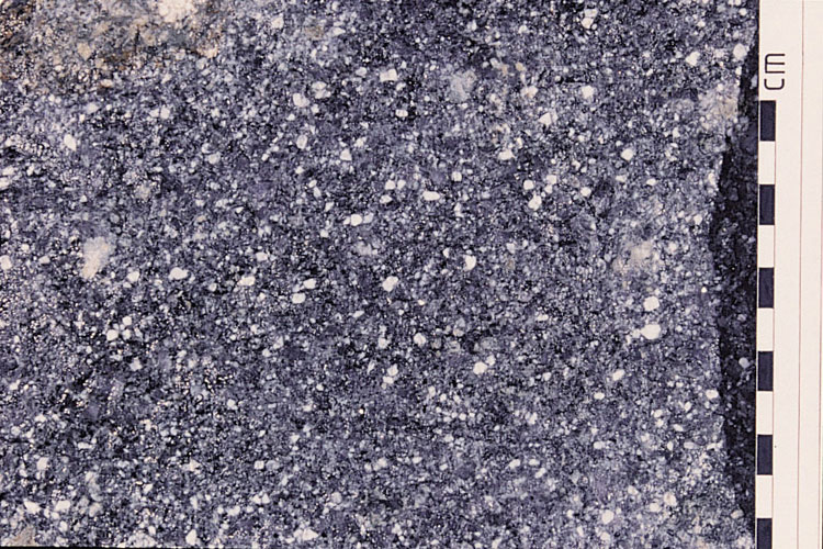
The formation is commonly a massive, largely featureless, pale grey to dark grey lapilli–ash or coarse ash crystal tuff (Plate 5.18). It contains mainly feldspar and quartz crystals, with some dark green biotite, and lithic lapilli of pale sandstone (up to 20 mm). Volcanic lithics are commonly flattened and sometimes aligned, resembling fiamme associated with a eutaxitic fabric. Welded lapilli–ash crystal tuffs are present near the summit of Tai Mo Shan along with rare bands of impersistent slightly tuffaceous sandstone, up to 30 m thick.
One possible source for the formation is the area around Tai Mo Shan. There may have been another source of eruption of the Tai Mo Shan Formation to the north of Tai Mo Shan. However, due to structural repetition associated with major thrusting in the northern New Territories, the sequence is not well established and interpretation is uncertain. Several sources of information suggest a possible volcanic source, or sources, north of Tai Mo Shan. These include: a concentration of granodiorite intrusions of similar composition around Shek Kong Camp; an outcrop of block-bearing tuff on Pak Tai To Yan; and evidence from gravity data of a localy thicker volcanic sequence. Given the apparently homogeneous nature of most of the tuffs, rapid accumulation is presumed from large pyroclastic flows.
Details
Tai Mo Shan. The base of the formation is exposed on the southern (830200 828800 Jtm-1) and southeastern (831550 828430 Jtm-2) ridges of Tai Mo Shan where lapilli-ash crystal tuffs overlie the ash vitric tuffs of the Shing Mun Formation. The Tai Mo Shan tuffs, besides being coarser, and rich in crystals and clasts of volcanic glass, are more homogeneous and weather more massively into cuboidal blocks, which in places form boulder fields. Proportions of different crystals vary, as does the state of preservation of crystal phases. This is particularly obvious with respect to feldspars and biotite, which are more conspicuous in certain exposures (833600 830550 Jtm-3). Lithic clasts of porphyritic volcanic glass, are common, generally 2-3 mm in length, although occasionally up to 30 mm and these are usually flattened in a moderately well developed eutaxitic fabric. Other lithic fragments, notably small clasts of pale grey sandstone and dark grey siltstone, are locally conspicuous. Despite the lithological variation within this sequence, none of the variants has proved to be mappable. The formation is very similar in its development on the ridge east of Tai Mo Shan (832200 830950 Jtm-4) and on the ridge enclosing the valley of Yuen Tun Ha. As on Tai Mo Shan, the tuffs commonly form fields of large tors and lag boulders surrounded by deep residual soils.
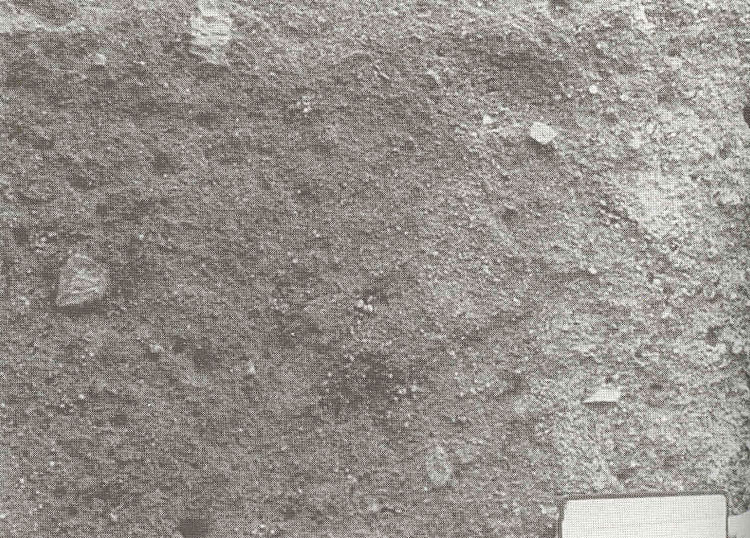
Tai Mo Shan to Ngau Liu. To the west of Tai Mo Shan, above Route Twisk, are exposures of pale grey, lithic lapilli bearing, ash and lapilli ash crystal tuff. The lithics are generally rounded to sub rounded, up to15 mm across, dark grey and very fine grained. The pyroclasts are dominantly quartz and feldspar that range in size from 6 mm to down to fine ash. The rock is characterized by the uniform scattering of subhedral, white feldspar crystals (Plate 5.A12) and the small, dark, pebble like lapilli.
South and southeast of Ngau Liu are outliers of the formation, probably resting on Shing Mun Formation. At one locality (828540 828960 Jtm-5) the grey ash crystal tuff is bomb bearing. The bombs are up to 150 mm across and are very fine grained in thin section (HK 3976); they may be lava or densely welded tuff. The tuff of this area is typically homogeneous, containing quartz and feldspar crystals up to about 3 mm, and, apart from the bombs, contains very rare, small lithic clasts.
Tai To Yan. The Tai Mo Shan Formation crops out on the summit and northwestern flank of Tai To Yan, where it consists mainly of lapilli ash and coarse ash crystal tuffs. The tuffs usually contain scattered, small, sub angular lithic lapilli of mudstone and siltstone. Secondary calcite and biotite characterise the tuffs seen in thin section.
On the southern and western flanks of Tai To Yan is lithic lapilli bearing lapilli ash crystal tuff of the Tai Mo Shan Formation. The rocks are dynamically metamorphosed to some degree, and the metamorphism is severe in a northeast trending belt from Pat Heung across the summit of Tai To Yan. The slightly metamorphosed tuff is pale grey to grey, with prominent feldspar crystals up to 8 mm, quartz up to 6 mm and rare lithics, mostly grey aphanitic lapilli up to 30 mm. The slight metamorphism obscures fine detail in the matrix, and in the strongly metamorphosed zones only relict quartz megacrysts remain of the original tuff texture.
Ho Hok Shan. The northern part of this area is dominated by schistose metatufl; but south of the summit of Ho Hok Shan the metamorphosed zones are restricted. The rocks are lithic lapilli bearing coarse ash crystal tuff, with at least one narrow sandstone unit. The tuff is pale grey, weathering pale orange brown, with quartz and feldspar crystals generally up to 4 mm, and lithic clasts up to 25 mm. Some lapilli are porphyritic and pale, while others are aphanitic and dark.
Pale brownish grey tuffaceous sandstone about 30 m thick is exposed on a ridge about 2 km southeast of Ho Hok Shan (824540 832140 Jtm-6), dipping 20o eastsoutheast. Tuffaceous siltstone debris indicates the presence of another sedimentary unit stratigraphically below the sand stone, but the outcrop form has not been determined. These two sedimentary units may correlate with those seen on the southern flanks of Kai Keung Leng.
Kai Keung Leng. The tuffs of Kai Keung Leng are mostly affected by dynamic metamorphism, either in broad zones or narrow northeast trending belts. Where original tuff textures are not obscured the rock is dark grey lapilli ash crystal tuff, often bomb and lithic lapilli bearing. Sandstone units outcrop on the southern slopes of the hill. On the western end of the ridge (824640 836000 Jtm-7) the tuff contains bombs of vesicular lava and possible pumice up to 250 mm across. At two localities east of Kai Keung Leng (572 m) the large clasts define a flow fabric that dips gently to the south (827200 836120 Jtm-8) or southwest (827270 835930 Jtm-9).
Two tuffaceous sandstone units can be traced along the hillside south of the summit (826000 835200 Jtm-10). Each unit is white less than 20 m thick and impersistent along strike; they probably dip steeply to the north, and may correlate with two metasandstones on the western end of the hill (824600 835400 Jtm-11). A series of exposures of fine grained sandstone can be seen near the base of the southeast flanks of the hill for example behind the Fire Services Department Training School (828100 835280 Jtm-12). At one locality (827090 834810 Jtm-13) the sandstone dips roughly north at 57o.
Western Aqueduct. Grey, lithic block and lapilli bearing, lapilli ash crystal tuff was exposed in the water tunnel for about 1 km south from the portal at Ko Po Shan Tsuen (823500 832900 Jtm-14). The rock contains scattered dark lithic clasts up to 200 mm conspicuous feldspar crystals up to 6 mm and quartz pyroclasts up to 4 mm across, but dynamic metamorphism obscures the original detail of the finer matrix.
About 0.4 km northeast of the portal at Fung Kat Heung are grey metatuffs and quartzite (824190 835930 Jtm-15). For the most part the effects of dynamic metamorphism obscure the original texture. Close to the portal (824570 835760 Jtm-16) is a grey lapilli ash crystal tuff with quartz crystals, feldspar crystals and possible lithics up to 4 mm. Further along the tunnel (824760 835860 Jtm-17) there was a narrow exposure of quartzite with scattered quartz crystals less than 1 mm.
Ma Tau Leng to Wong Mau Hang Shan. From Ma Tau Leng (833500 841600 Jtm-18) to Wong Mau Hang Shan (836000 845380 Jtm-19), the formation comprises rhyolitic, coarse ash lithic crystal tuffs. As the area is bounded by the San Tin and Sha Tau Kok faults (Figure 5.A4), however, the tuffs have been subjected to varying degrees of shearing and metamorphism. Near the San Tin Fault in particular, the tuff is mylonitized. The carbonaceous metasandstone, tuffaceous metasiltstone and phyllite at Wong Mau Hang Shan were deposited in a minor basin that may have been an ancient volcanic crater lake.
Pak Tai To Yan to Lung Shan. In the area of Pak Tai To Yan (831240 836340 Jtm-20) and Lung Shan (834540 839040 Jtm-21), the rocks are grey to dark grey, lapilli-bearing coarse ash lithic crystal tuff, clasts comprising 50 % and 70 % of the rock respectively. Block-bearing coarse ash lithic crystal tuff occurs on the summit of Pak Tai To Yan. The blocks, comprise siltstone and sandstone and are 250 to 1,000 mm in size, suggesting the proximity of a volcanic vent. Near the Sha Tau Kok Fault Zone, the rocks are foliated and slightly metamorphosed, the rotation of the foliation into parallelism with the fault suggesting sinistral movement.
Kau Lung Hang Shan to Hsien Ku Fung. Lithic clasts comprise 45 to 80 % of the crystal lithic tuff between Kau Lung Hang Shan (835600 837360 Jtm-22) and Hsien Ku Fung (842160 838380 Jtm-23) at the eastern end of the Pat Sin Leng. Red beds of the Pat Sin Leng Formation overlie the formation in this area. The contact with the underlying Shing Mun Formation is gradational and is defined, as around Kau Lung Hang Shan, on the presence of abundant sedimentary rock intercalations and sedimentary blocks in the Shing Mun Formation but not in the Tai Mo Shan Formation. In the Pat Sin Leng area, the Tai Mo Shan Formation directly overlies a 1 to 5 m-thick siltstone in the Shing Mun Formation. Locally, close to the Sha Tau Kok Fault Zone the tuffs are weakly foliated. A thin, reddish brown siltstone at Hok Tau Reservoir probably represents deposition in a small intermontane lake.
Ma Tau Fung to Wong Chuk Kok Tsui (Bluff Head). Mainly lapilli-bearing coarse ash lithic crystal tuff and some coarse ash crystal lithic tuff are present in a narrow outcrop, 60 to 600 m wide, in the Kwun Yam Shan area, between Ma Tau Fung (843540 839680 Jtm-24) and Wong Chuk Kok Tsui. Between Siu Kau and Wong Chuk Kok Tsui, a northeast-trending fault separates the formation from the Bluff Head Formation to the southeast. Due to the intensity of erosion, the formation is seen mainly in small, isolated exposures along streams and in low ground at Shek Tsai Wan (851740 840780 Jtm-25) and Wong Chuk Kok Tsui (852300 841250 Jtm-26, 852450 841200 Jtm-27).
Wang Leng Tau to Tai Lung. Exposures on the north side of Plover Cove Reservoir are characterized by abundant lithic blocks in a coarse ash crystal tuff. Blocky lithic clasts and intercalations of sandstone and mudstone occur 450 m south of Tai Lung (845360 838330 Jtm-28) and near Wang Leng Tau (844400 838550 Jtm-29, 844300 838600 Jtm-30 and 844440 838470 Jtm-31).
Tiu Tang Lung to Kei Shan Tsui. The rocks between Tiu Tang Lung (844700 841280 Jtm-32) and Kei Shan Tsui (843340 845400 Jtm-33) mainly comprise lithic crystal ash tuff, with welded tuff and rhyolite lava. Greenish grey, lithic crystal welded tuff is present at Tiu Tang Lung, and there is a porphyritic rhyolite at Pan Pui Teng (844500 843520 Jtm-34). The formation is overthrust from the north, by the Pat Sin Leng Formation. The tuff is mylonitized close to the fault zone, from south of Tiu Tang Lung to Fan Kei Tok, and from south of Kwai Tau Leng (838080 840140 Jtm-35) to Lo Lung Tin (838700 840800 Jtm-36).
Wong Wan Chau (Double Island) to Wong Fong Shan, Kat O Chau (Crooked Island). On the islands in the east of the district, including Kat O Chau (Crooked Island), the northwest of Ngo Mei Chau (Crescent Island), and Shau Kei Pai and Tai Lo Pai, the formation mainly comprises lapilli-bearing coarse ash lithic crystal tuffs with a few lapilli tuffs and occasional rhyolite lava. The lapilli are 5 to 50 mm in size, and quartz crystals are 1 to 5 mm. A whole-rock chemical analysis (HK 9455) confirms that the rock is rhyolitic. The contact with the underlying Pat Sin Leng Formation on Wong Wan Chau is a thrust, and that with the Ngo Mei Chau Formation is a northwest-trending fault.