
Geological Mapping
The first geological survey of Hong Kong was carried out in the1920s and the first map was published in 1935. Further work continued in the 1930s and 1940s and in 1952, the first memoir was published. In 1971, a geological map of Hong Kong was produced in two sheets at a scale of 1:50,000 together with an accompanying report. Since 1982, a permanent Geological Survey has been maintained as part of the Geotechnical Engineering Office of the department of the Hong Kong SAR Government. It has then undertaken a completely new survey of the land areas of Hong Kong at a scale of 1:20,000 and has surveyed the offshore areas for the first time. Fifteen 1:20,000-scale geological map sheets and six explanatory memoirs have been published during this mapping project period which ended in 1996. A recently completed 1:100,000-scale geological map which is available in both Chinese and English synthesises much of the recent interpretations based on new field, geochemical and geochronological data was published in 2000. Currently, the pre-1996 1:20,000-scale map sheets are being revised based on the systematical interpretation of all available subsurface geological information derived from the ground investigation and underground engineering projects distributed throughout the territory. The updated maps will be released on the Geographic Information System platform.
The map at left is a simplified geological map of Hong Kong showing major lithological units and faults.
- Pink/red: granitic rocks,
- Green/blue: volcanic rocks,
- Brown: sedimentary rocks,
- Yellow: superficial deposits.
Geophysical Surveys
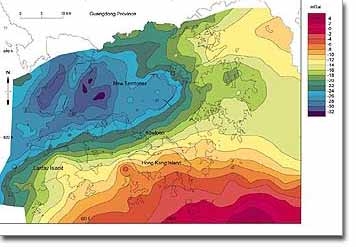
A regional gravity survey of Hong Kong was commissioned in 1991 and magnetic surveys have been conducted for the entire offshore area. The gravity data have been analysed to investigate the deep geological structure beneath Hong Kong. It is now thought that the regional gravity gradient that crosses Hong Kong is the result of a major northeast-trending structural discontinuity in the earth's crust at a depth of at least six kilometres. The magnetic data enables faults in bedrock in the offshore area to be identified, several of which are continuations of structures previously identified during onshore surveys. Shallow seismic data from marine infrastructure development involving 5000 km of boomer seismic survey records have allowed a detailed stratigraphy of the offshore superficial deposits to be constructed.